January
Science Results from the Mars Exploration Rover Mission
2008 Emmons Lecture
Steven W. Squyres, Goldwin Smith Professor of Astronomy, Cornell University; Principal Investigator, Mars Exploration Rover Project
Abstract: The two Mars exploration rovers, Spirit and Opportunity, touched down on Mars in January 2004 and have been conducting extensive observations with the Athena science payload. Together the two rovers have traversed approximately16 km. Spirit, located on the floor of Gusev crater, has investigated basaltic plains, as well as older materials in the Columbia Hills. The rocks of the Columbia Hills are largely clastic in nature and range from breccias to finely laminated deposits that have undergone significant aqueous alteration. They appear to be largely a mixture of altered impact ejecta and explosive volcanic materials. Recently, Spirit has discovered silica-rich deposits that may have formed in a hot spring or fumarole environment. Opportunity has carried out the first outcrop-scale investigation of ancient sedimentary rocks on Mars. The rocks are sandstones formed by wind and water erosion and re-deposition of fine grained siliciclastics and sulfate-rich evaporites. The stratigraphic section observed to date is dominated by eolian bedforms, with subaqueous current ripples exposed locally near the top of the section. While liquid water was present at Meridiani below and occasionally at the surface, the ancient environmental conditions recorded there are dominantly arid, acidic and oxidizing, and would have posed some significant challenges to life.
February
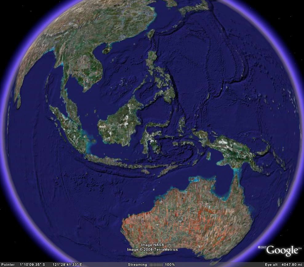
The gradual closing of the Indonesian Seaway and the onset of northern hemisphere ice ages
Peter Molnar, University of Colorado
Abstract:A logical argument can be made that the closing of the Indonesian Seaway transformed the shallow, tropical Pacific Ocean from a state resembling that during large El Niño events to its modern weakly La Niña state, and with that change, atmospheric heat transport to Canada decreased sufficiently to permit the growth of large continental ice sheets. The steady northward movement of New Guinea and the concurrent emergence of islands in the “Maritime Continent” (largely Indonesia) has blocked relatively warm Pacific water south of the equator and enabled cooler water from the northern Pacific to escape into the Indian Ocean (the “Indonesian Throughflow”). Blocking of that warm water may have strengthened easterly winds and amplified an east-west temperature gradient. Paleoceanographic evidence, indeed, shows a gradual cooling of the water in the eastern Pacific to its present-day “cold tongue” that flows at the equator half way across the eastern equatorial Pacific. Thus, the sea surface temperature of the eastern Pacific has gradually changed from the warm state that is reached only rarely today during major El Niño to its more common present-day cold state. Moreover, during present-day El Niño events, distant regional climates respond, via “teleconnections,” in varying ways in response to the changes in sea-surface temperatures in the eastern Pacific.
Similarly, paleoclimates from most of the earth differ from normal present-day climates. These differences, those between paleo- and typical modern climates, resemble those associated with modern teleconnections, which corroborates the idea that before ~3 Ma, the tropical Pacific Ocean was in a state similar to that during El Niño events. For example, during El Niño events, not only do winters in Canada become atypically warm, but also summers last longer than normal. An assessment of the dependence of positive-degree days in Canada associated with El Niño events, together with empirical estimates of melting rates of snow or ice as a function of positive-degree days, suggests that an eastern Pacific 3- 4 degrees C warmer than today, as it was at 3-4 Ma, sufficed to melt winter snowfall and prevent ice sheets from growing. The gradual cooling of the eastern Pacific and reduced atmospheric heat transport finally enabled ice sheets to grow.
March 2008
Glacial Lake Riverton, Wind River Basin, Wyoming
Dr. Richard M. Pratt, Denver Museum of Nature and Science
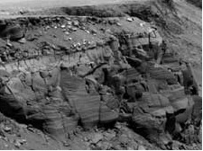
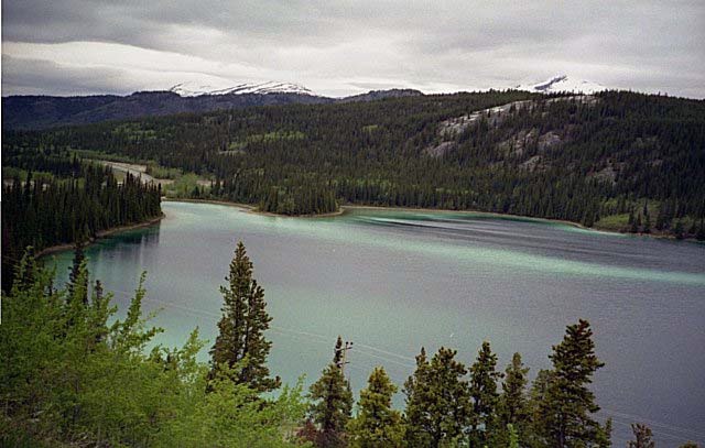
Abstract: Glacial Lake Riverton formed in the central Wind River Basin during the Bull Lake (Illinoian) glaciation around 140,000 years ago. At its maximum extent, the lake stretched 95 miles east-west, 57 miles north-south, and could have been 700 feet deep. The lake overflowed through Arminto Gap into the Powder River drainage. This eastern overflow stabilized the lake level at about 6,100 feet elevation; however, the absence of a pronounced valley or canyon indicates that the flow was never large. The west end of the lake was dominated by the Bull Lake glacier spewing icebergs directly into the lake. Erratic material in the form of large, angular, exotic drop-stones and partially sorted shoreline gravel is distributed around the lakeshore; it is particularly concentrated in the far northeast where icebergs were blown by dominant westerly winds. A fine-grained rose-pink granite and a quartz-rich spotted gneiss along with the general suite of light metamorphic rock types can be traced directly to the Bull Lake moraines that define the extent of the lake. Shoreline physiographic features are mostly obliterated by subsequent pedimentation and stream erosion except near Arminto Gap where a well-preserved beach ridge was found.
Glacial Lake Riverton drained by stream capture and diversion through Wind River Canyon. The diversion probably occurred when a southward-heading stream from the Big Horn Basin tapped through the Paleozoic karstic limestones (Madison Limestone or Bighorn Dolomite) to initiate the drainage flow. The Bull Lake (Illinoian) timing of this event has broad implications for the erosion history for both the Wind River Basin and the Big Horn Basin.
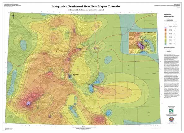
Geothermal Resources of Colorado and the Potential for Electrical Power Generation
Matt Sares, Colorado Geological Survey
Abstract: As of 2005, renewable energy sources supplied almost 9 percent of the electrical power supply in the U.S. Of the total renewable energy sources, conventional hydroelectric energy supplied 80.8 %, biomass 9.2 %, wind 5.4 %, geothermal 4.4 % and solar 0.2 %. Most of the U.S.’s geothermal activity takes place in California and Nevada, but Alaska, Hawaii, and Utah also have some generation. New Mexico, Idaho, and Oregon have new projects underway in various stages of development.
Currently, geothermal resources in Colorado are used directly for recreation (pools/spas), greenhouse agriculture, aquaculture, space heating, and district-wide heating – but not for electrical power. Several lines of evidence indicate that the geothermal potential for Colorado may be underestimated in regard to electrical generation:
- High heat flow – Colorado has the second largest heat flow anomaly in the U.S.
- Quaternary volcanism (occurring within the last two million years) – Colorado has five such volcanoes
- Quaternary faulting (younger faults have more potential) – Colorado has over 90 such faults
- Rift zone tectonics in the San Luis Valley and upper Arkansas River basin.
- A low-velocity seismic P-wave anomaly in central Colorado, The Aspen Anomaly, indicates a significant area of less dense, warmer upper mantle. This could contribute to higher geothermal gradients in the area.
Two sedimentary basins in Colorado indicate potential for geothermal resources at depths in the range of existing oil and gas wells. Oil and gas fields in the Denver Basin and have recorded bottom-hole temperatures that range between 200-250°F at roughly 10,000-11,000 feet. Similarly, bottom-hole temperatures in the San Juan Basin south of Durango have recorded temperatures ranging from 150 – 250°F at depths of between 6,500 – 9,000 feet. Twenty of these wells have temperatures of 250°F or more
The Colorado Geological Survey, using data from thermal spring and wells, mineral exploration holes, and geothermal test holes, has constructed statewide maps of geothermal heat flow and geothermal gradient to identify the most prospective areas for geothermal resource development. These maps can be used to assist in identifying locations for conventional shallow hydrothermal systems as well as areas where enhanced geothermal system technology can be applied to tap deeper geothermal resources, 10,000 to 30,000 feet deep in the earth’s crust.
April
Amazonite-bearing pegmatites in the Pikes Peak batholith, near Harris Park, Park County, Colorado
Leader Pete Modreski, USGS
We’ll meet at 8 a.m. at the Cold Spring RTD Park-and-Ride on Union Blvd just south of 6th Avenue in Lakewood. Travel will be by car-pooling; those who live along US-285 can also meet us at approximately 8:30 a.m. at the Twin Forks Park-and-Ride, located on the south side of US-285 about ½ mile west of the Indian Hills (Parmalee Gulch) turnoff and just past South Turkey Creek Road. We’ll be driving to Harris Park, located about 6 miles north of US-285 from Crow Hill, and then on Forest Service dirt roads about 2 miles to the site, a total of about 45 miles from Lakewood.
We will be able to hunt in the granite pegmatites for smoky quartz, microcline var. amazonite, and if one is fortunate, goethite, fluorite, and topaz. Pete will brief the group about the geology of the pegmatites and the minerals found in them. The area is pleasant, lightly wooded with a small stream, and is kid-friendly. The site is on mining claims maintained by the Littleton Gem and Mineral Club, and we will be there courtesy of that club. Depending on how industrious you want to be in searching for or digging for minerals (the best are found down in the undisturbed soil or bedrock, you know), bring any or all of a rock pick, trowel, chisel, sledge, a small or large shovel, and pickaxe. Safety glasses or goggles are advised if splitting rocks, as well as suitable sun/rain/snow protection depending on the weather. You will also be required to bring your own lunch, drinks, and snacks. There will be no charge for this trip.
Road access should be no problem if the weather is good, but any late April-early May snows could change that; if in doubt, check with Pete, or the Colorado Scientific Society website (www.coloscisoc.org). If the road is in good condition any vehicle may be able to reach the site, but SUV’s are recommended if you have one. No RSVP is necessary.
May
Interplay of tectonic and oceanographic/paleoclimate events during middle to late Miocene sedimentation across the southwestern U.S.
Charles E. Chapin, New Mexico Bureau of Geology and Mineral Resources, New Mexico Institute of Mining and Technology
Abstract: Continental sedimentation reflects a complex interplay of tectonics and climate. A 2000-km transect from coastal California to the western Great Plains documents a major increase in sedimentation in earliest middle Miocene (ca. 17-15 Ma). Basin and Range-style regional extension following elongation of the Pacific-North American transform boundary at 17.5 Ma provided fault-bounded basins for accumulation of continental deposits. Sedimentation also occurred in transtensional basins along the transform boundary and on unextended erosional surfaces of the Great Plains and Colorado Plateau. Upwelling along the California Coast deposited the hemipelagic Monterey Formation (ca. l6-6 Ma) coeval with continental sedimentation. Three tectonic/oceanographic events that strengthened thermohaline and Pacific gyral circulation were: 1) Opening of Fram Strait (17.5 Ma), 2) growth of the East Antarctic Ice Sheet (14.2-13.8 Ma), and 3) closing of the Indonesian Seaway (12-10 Ma). Upwelling of cold waters along the California Coast, abetted by domination of La Nina phases of ENSO, progressively aridified the Southwest as reflected in both the sedimentary and biologic records. Opening of the Gulf of California (6.4 Ma) intensified the North American monsoon resulting in integration of drainages, incision of uplifts, and exhumation of basin fills. The Miocene ended with the driest climate of the Tertiary accompanied by conversion of savanna to steppe or scrub desert, spread of C4 grasses, and extinction of 35 genera of large mammals. The answer to the long-running controversy over tectonic uplift versus changing climate in continental sedimentation/erosion is not either/or, but the complex interplay of both.
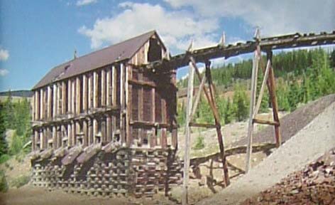
When mining was king of the mountains — a photo tour of Colorado’s mining history
J. Harrison Daniel, Ph.D, PE.
Abstract: Travel through the historic mining districts in Colorado to view our mining heritage from the turn of the century when “Mining Was King of the Mountains.” The impressive and treasured structures and ruins were largely responsible for the building of our Nation and in establishing the United States as a world leader. Districts include Central City, Leadville, Red Mountain Pass, Summitville, Bonanza and Victor.
September
Paleontology, Paleoecology, and Climate in an Early Eocene, High Arctic Swamp Forest
Jaelyn J. Eberle, University of Colorado Museum of Natural History and Department of Geological Sciences, University of Colorado, Boulder, CO
Abstract: The Early Eocene marked the peak of global warming since onset of the Cenozoic Era (ca. the last 65.5 million years), when mid-latitude mean annual temperatures soared, and the High Arctic was home to lush swamp forests inhabited by alligators, giant tortoises, and a diverse mammalian fauna that included primates and tapirs. As the relevant fossil-bearing rocks of the Eureka Sound Group on central Ellesmere Island were well above the Arctic Circle during Eocene time and only 1–2º degrees further south than today (~77º N.), this environment experienced months of continuous sunlight and darkness, the Arctic summer and winter, respectively.
Resulting from over three decades of paleontological field research, the early Eocene (Wasatchian) mammalian fauna from the Eureka Sound Group on Ellesmere Island comprises over 20 genera, ranging from tiny rodents and insectivorans to tapirs, brontotheres and hippo-like Coryphodon. Complementing the paleontology, stable isotope geochemistry, in particular oxygen and carbon isotope analyses of bone and tooth enamel, indicate a warm temperate paleoclimate and provide valuable paleoecologic insight into the early Eocene High Arctic vertebrate fauna. More specifically, δ18O values from co-occurring mammals, turtle, and fish estimate mean annual temperature (MAT) at ~8–13ºC, with a warm month mean temperature of up to ~24ºC. Analyses of both carbon and oxygen isotope ratios of mammalian tooth enamel suggest that the large herbivorous mammals were year-round inhabitants in the Eocene High Arctic, a probable prerequisite to dispersal across northern high latitude land bridges.
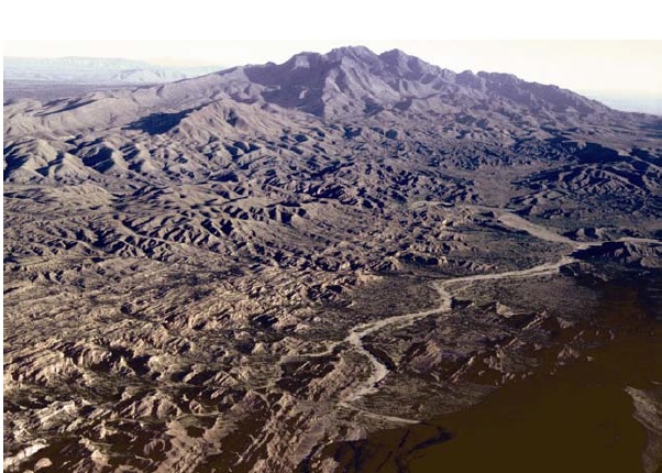
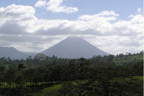
Costa Rica: Geology, Sea Turtles, and Leafcutter Ants
John L. Lufkin, Consulting Geologist
Abstract: Costa Rica is located in Central America, bordered by Nicaragua on the north and Panama on the south. It is the second-smallest nation after El Salvador, and comprised of almost 51,000 sq km. It is situated in the tropics, between 8 and 11 degrees north latitude. Most of the people of the country of over 3 million live in and around San Jose, the capital located in the central part of the country. Liberia, with a population of 40,000, is the largest city in the north. I have made two visits to Costa Rica in the past two years, and have become particularly interested in the geology, sea turtles, and leaf cutter ants residing there.
Costa Rica lies at the junction of the Cocos and Caribbean plates. Consisting of heavier basaltic rock, the Cocos plate is being subducted eastward underneath the Caribbean plate. The process of subduction is widespread around the Pacific basin, where linear volcanic chains of andesitic rock are produced. The geology of northern Costa Rica is underlain by Cretaceous, Tertiary, and Quaternary rocks. Rocks of Cretaceous age include mostly shales, graywacke, conglomerate, limestone, and chert. The Santa Elena Peninsula, however, is underlain by ultramafic rock. The coastal area north of Santa Elena Peninsula is composed of sedimentary and volcanic rocks. The interior lowland is underlain by lacustrine sediments, tuffs, and dacitic lavas. The backbone of Costa Rica, forming the dominant mountain range, or Cordillera, is volcanic in origin, and consists of pyroclastic rocks, tuffs, and lava flows of andesitic and basaltic composition. Thick deposits of pyroclastic mudflows, or lahars, flank the Cordillera. The greatest tourist attraction in Costa Rica is the majestic and active volcano, Arenal, a 5-hour drive ESE of Liberia. The eruptive history of Arenal spans about 7,000 years, consisting of both explosive eruptions and more effusive, lava outpourings. Over the past 4,000 years Arenal has produced tephra layers roughly every 300 years.
There are seven species of sea turtles worldwide, and the Green, Leatherback, and Olive Ridley are common visitors to the beaches of Costa Rica. The Leatherback is the largest known sea turtle, and also the one without a solid shell. On the West Coast, the Leatherback has a protected nesting site in the vicinity of Playa Grande and Tamarindo. To the south, the Olive Ridley turtle nests on the beaches of Ostional.
The Leafcutter ants form huge colonies, and can be found throughout Costa Rica. They march single file through the rainforests on trails a foot wide, carrying leaf sections at least twice as large as the ants themselves. The life and importance of these interesting creatures will also be discussed briefly.
October
Resource Constraints on Alternative Energy Development
Jim Burnell, PhD., Colorado Geological Survey
Abstract:Public support is growing for the development of energy generation from renewable sources. An aspect of renewables that is possibly unknown by many, however, is the hardware needs for these technologies. The infrastructure requires mined materials, including imported strategic and critical minerals. Silica, copper, gallium, indium, selenium, cadmium and tellurium are required for the dominant photovoltaic technologies. Silver and aluminum are necessary for “concentrating solar power” technology. Zinc, vanadium, platinum group metals, and rare earth elements are key components of power storage, hybrid vehicle, and fuel cell applications. All these materials must be mined. At present, the U.S. is woefully dependent upon import sources for most of these materials and demand is already squeezing the prices. Domestic sources must be found and developed if energy independence is to be achieved using alternative sources.
The Great CSS Geological Collection
Beth Simmons, Metro State University, rogue geologist
Abstract: When did CSS win a gold medal at world-expositions? Where were the “fairs”? What did the Society display? Come to the next CSS meeting to learn the answers to these Society trivia questions. By the end of 1883, less than a year after inauguration, CSS members began to amass its great geological collection and technological library. For 20 years or more, the collection grew. Moving and housing the collection and library became a major problem as the Society went from pillar to post finding meeting places. When the library was finally donated to Denver Public Library in 1977, the accumulated journals and books practically filled an entire room! After being moved all over Denver, the geological collection was housed in the Colorado History Museum in 1914, where it remained until the Society donated the specimens to the Historical Society in the 1920s.
When the Museum moved to its new building (which is soon to be demolished), the Historical Society transferred the over 2,000 specimens in the CSS collection along with the State Bureau of Mines collection to the Colorado School of Mines Geology Museum where both collections reside today, complete with records.
Some CSS specimens, particularly the meteorites, were placed in the Denver Museum of Nature and Science, where Robert Nininger cataloged them and studied them. The most precious specimens of all, two Smuggler-Union gold ore specimens, originally from John A. Porter, were finally donated to and displayed at the DMNS in 1977.
The study of the CSS collection illustrates the growth of the Colorado Scientific Society and the development of science and mineral technology in the Rocky Mountains. It shows the importance Society members placed on specimens that demonstrated, not beauty, but scientific principles. Through the CSS Proceedings and meeting minutes, most of the specimens can be traced to reveal their own precious stories.
Modern-day scientists who study the mineralogy of particular mines, mining districts, or even rocks like coal from locales throughout the West, or early metallurgical processes, should investigate these specimens that were collected and catalogued over one hundred years ago. They provide a wealth of information from places that may no longer exist!
Come to the next CSS meeting to hear about and see some of the vestiges of the great CSS Collection!
November
Late Miocene through Pliocene evolution of the Angastaco basin (NW Argentina): Implications for the tectono-climate evolution of the Eastern Cordillera in the late Cenozoic
Sharon Bywater, (University of Wyoming), Master’s candidate in Geology
Abstract: The Angastaco basin is located in the Calchaquí valley in NW Argentina between the Eastern Cordillera (EC) to the west, and Santa Barbara (SB) system to the east. Uplift of the eastern basin-bounding range, the Sierra de los Colorados of the SB, and development of an orographic effect, is postulated to have occurred between 3.4 and 2.4 Ma (Coutand et al., 2006). The Angastaco basin-fill consists of four formations: the Quebrada de los Colorados, the Angastaco, the Palo Pintado, and the San Felipe (Díaz & Malizzia, 1983). The Pliocene San Felipe Formation holds key information concerning the tectono-climate evolution of this part of the Andes, including: timing of uplift of the eastern basin-bounding range as well as timing of development of an orographic barrier and subsequent onset of aridity. Lithofacies interpretations derived from measured stratigraphic sections for the upper ~1 km of the late Miocene Palo Pintado Formation and throughout the San Felipe Formation are consistent overall with previous studies: the Palo Pintado Formation is interpreted as fluvial to lacustrine deposits, whereas the Pliocene San Felipe Formation is interpreted as braided stream and alluvial fan deposits (Díaz & Malizzia, 1983; Coutand et al., 2006). Lithofacies associations suggest a transitional boundary between the two formations.
Preliminary U-Pb SIMS dating of zircons from an ash layer near the Palo Pintado-San Felipe transition confirms ca. 5 Ma as the transition age. Provenance data document a decrease of western (EC) sources up section and a final switch to eastern (SB) sources within the uppermost San Felipe Formation. These data constrain exhumation of the eastern basin-bounding range to upper San Felipe time (ca. 2-3 Ma), supporting the model of Coutand et al. (2006). Paleocurrent data show an axial NNE-flowing drainage during upper Palo Pintado deposition, an E-flowing drainage during San Felipe deposition, and a SW-flowing drainage during uppermost San Felipe deposition. Stable isotope data (13C and 18O) from paleosol carbonates suggest a woodland or montane grassland environment (Cerling, 1992) during Palo Pintado deposition trending towards more arid conditions by the Palo Pintado-San Felipe transition. These data suggest arid conditions within the basin prior to exhumation of the eastern basin-bounding range. The mismatch between timing of onset of aridity (ca. 5 Ma) and exhumation of the range previously thought to be responsible for the orographic effect (ca. 2-3 Ma; Coutand et al., 2006) suggests either that climatic variability is not controlled by local uplift of basin-bounding ranges, or that ranges farther east are responsible for the orographic effect.
A refined interpretation of the Medicine Bow orogeny, southeastern Wyoming: Implications for regional tectonics and crustal growth
Daniel Jones, (University of Wyoming), Ph.D. candidate
Abstract: New SHRIMP ages from the Big Creek gneiss, southern Sierra Madre, southeastern Wyoming, indicate a complex Paleoproterozoic magmatic-tectonic history. The analyzed rocks have been interpreted as part of the Paleoproterozoic Green Mountain arc. The accretion of this arc, together with syn- to post-collisional granitic rocks (e.g., Sierra Madre granite), has been referred to as the ca. 1.78-1.75 Medicine Bow orogeny.
The new SHRIMP ages consist of 161 points (9 samples) from a representative suite of (meta)igneous rocks from the Big Creek gneiss. The oldest ages (~1.78 Ga) are from metagabbroic and granitic gneiss that are correlated with the Green Mountain Formation and related intrusions. The zircons contained no older, xenocrystic cores. The lack of significant spread in the arc-related ages suggests that the arc accreted shortly after crystallization of these rocks, perhaps by slab rollback related to a southward-dipping subduction zone. Two samples of augen gneiss and two samples of Fe-rich mafic rocks (one partially mingled with augen gneiss) yielded ages of ca. 1,767 Ma, corresponding to the massive phase of the Sierra Madre granite. This episode of bimodal magmatism may correspond to the breakoff of the subducted slab and represent a second phase of juvenile magmatic addition to the crust. Finally, zircons from a paragneiss leucosome, interpreted as having crystallized from a syntectonic, in-situ anatectic melt, yielded an age of ca. 1,750-1,745 Ma, coeval with metamorphic zircon rims from other gneissic samples. This metamorphic and deformational event likely records a tectonic event to the south, possibly due to a southward jump in active subduction.
In summary, the Medicine Bow orogeny apparently comprises three tectonic events: (1) accretion of the Green Mountain arc at ~1,780-1,775 Ma; (2) slab breakoff at ~1,763 Ma; and (3) inferred contraction from the south at ~1,750-1,740 Ma.
High-resolution geo-cellular modeling of Upper Morrow ‘A’ Sands at Postle Field, Texas County, Oklahoma
Dawn Jobe, (Colorado School of Mines), Reservoir Characterization Project (RCP)
Abstract: New SHRIMP ages from the Big Creek gneiss, southern Sierra Madre, southeastern Wyoming, indicate a complex Paleoproterozoic magmatic-tectonic history. The analyzed rocks have been interpreted as part of the Paleoproterozoic Green Mountain arc. The accretion of this arc, together with syn- to post-collisional granitic rocks (e.g., Sierra Madre granite), has been referred to as the ca. 1.78-1.75 Medicine Bow orogeny.
Pennsylvanian-aged Morrow valley-fill sandstones are prolific producers of oil and gas in the mid-continent. Upper Morrowan reservoirs are particularly attractive because of their abundant reserves, good production history, and shallow depths; but are often poorly developed because of severe heterogeneity caused by rapid and extreme changes in facies and grain size. Understanding the reservoir heterogeneity has direct implications for interpretation of flow units and ultimately increased recovery and efficiency.
Postle Field, Texas County, Okla., produces from the Upper Morrow ‘A’ sands and has over 300 million barrels of original oil in place. Today, only 40% of the OOIP has been produced. The small recovery is due to the difficulty of production caused by the extreme heterogeneity in the field. The goal for RCP’s Phase XII study at Postle is to identify and characterize the reservoir architecture, which is highly complex and changes over very short lateral and vertical distances.
The study area is a 6.25-square-mile block within Pestle Field, over which a multi-component 3-D seismic survey was shot in March of 2008. The study area includes 63 wells of which log data was available as well as 4 cored wells. Detailed core descriptions and facies determinations, as well as well-log correlations, were integrated with seismic interpretation to produce a new depositional model for the area.
A high-resolution geo-cellular model that incorporated cores, vertical proportion curves, and seismic attributes was then created. Integration of different scales of data into the facies modeling maintained the heterogeneity and yielded a more accurate distribution of facies and reservoir properties. The model was then up-scaled and history matched for future use in geo-mechanical and fluid flow simulation.
Soil respiration following pulse precipitation events in a semiarid grassland
Tyler Benton¹ ², Seth M. Munson³ , William K. Lauenroth³ 4, and Ingrid C. Burke³
¹ Colorado School of Mines;
² SGS-LTER Research Experience for Undergraduates, Colorado State University (CSU), Fort Collins;
³ Dept. of Forest, Rangeland, and Watershed Stewardship, CSU, Fort Collins;
4 Graduate Degree Program in Ecology, CSU, Fort Collins
Abstract: Semiarid and arid ecosystems are pulse-driven systems. At the daily time scale, the nearly continuous dry soil is irregularly interrupted by brief wet periods. The duration of these wet periods depends on the size of the precipitation event. The precipitation regimes in semiarid and arid environments, and therefore the pulsing regimes, are dominated by small events (less than or equal to 10 mm). The goal of our research was to determine how small precipitation events (2mm, 5mm, and 10mm) affected the dynamics of soil respiration and water loss in the shortgrass steppe. Because land-use change has resulted in a patchwork of large-scale disturbances in this region, we estimated respiration and water loss from sites that varied in time since cultivation disturbance (4 and 20 years after cultivation, and undisturbed shortgrass steppe).
Total carbon respired and duration of elevated soil respiration increased as event size increased in all sites. Total carbon loss ranged from 0.3 g C/m² (0.01% of carbon in ANPP) after a 2mm pulse in a field 20 years after cultivation to 3 g C/m² (6% of carbon in ANPP) after a 10mm pulse in undisturbed shortgrass steppe. Time since cultivation did not significantly affect the total carbon respired for 2mm pulses, but increased in importance as event size increased. The smallest events (2mm and 5mm) caused a respiration response that lasted longer than it took soils to lose water from the pulses, whereas for the largest event (10mm), respiration returned to baseline before the added water had been depleted.
Our results suggest that water is the most limiting factor to soil respiration rates for the smallest events, but becomes less limiting for events above 5 mm. Small precipitation events have the potential for large short-term losses of carbon in the shortgrass steppe.
December
Non-Terminal Meteorite Impacts: The Case for Studying Small Cratering Events
Matt Morgan, Colorado Geological Survey
Abstract: The importance of studying small meteorite impact craters (D <100 m) has often been overshadowed by larger, and thus more damaging, cratering events. Recent small impacts have provided us with a wealth of information including, but not limited to: shock metamorphism, orbital mechanics, cratering dynamics, and meteorite science. The first scientific investigation of a small impact crater was conducted by H.H. Nininger in 1933 in Brenham, Kansas, after he was told of a site that was a “buffalo wallow.” He dug two trenches across the site and proceeded to recover several thousand meteorite specimens totaling 1,200 pounds. The Carancas, Peru, impact event of September 2007 made international news when a 2-ton meteorite struck a riverbed south of Lake Titicaca. The impact created a crater nearly 50-feet wide and 16-feet deep, launching debris 650 feet into the air and registering the first-ever recorded seismic shockwave from a direct impact. The Wabar craters, located in Saudi Arabia’s “Empty Quarter,” contains grains of sand that have been welded together following the impact of a 3,500-ton iron meteorite that struck with a velocity of 15,000 miles per hour. The 13 kilotons of energy released from the impact blast is comparable to that of the atomic bomb dropped on Hiroshima, Japan, during World War II. From eyewitness accounts of the Sikhote-Alin, Russia, meteorite impact, scientists were able to deduce the meteoroid’s origin between the orbit of Mars and Jupiter. Other small impact craters provided information about cratering dynamics that could not be simulated through laboratory exercises. By studying these events in their natural surroundings, we can gain a better understanding of how small craters form and the severity of the hazard posed by small-impact cratering events. – ‘A’ RCP’s