January
The Future of Electricity: Future Trends in Electrical Delivery, Demand and Generation Systems
2009 S.F. Emmons Lecture
Tom Plant, State of Colorado Governor’s Energy Office
Abstract: The focus of Tom’s talk will be about the future of electricity. Tom will address the changing nature of our electrical delivery, demand and generation systems, and the resulting necessary changes in our electricity infrastructure. Tom will review some of the current developments at the State and Federal level to push us toward the envisioned changes. Tom’s discussion of the future of electricity is very timely due to the new administration’s inauguration two days prior to the talk and the debate that will be raging throughout January on the economic stimulus bill, as well as the potential re-opening and authorization of the Energy Act of 2005.
Biography: Tom Plant is the Director of the State of Colorado Governor’s Energy Office. In 2007, Colorado Governor Bill Ritter, Jr., re-created the Governor’s Office of Energy Management and Conservation (originally created in 1977 to promote energy conservation in Colorado) as the Governor’s Energy Office (GEO). The GEO’s mission is to lead Colorado to a “New Energy Economy” by advancing energy efficiency and renewable, clean energy resources. The GEO works with communities, utilities, private and public organizations, and individuals to promote renewable energy such as wind, solar, and geothermal, and energy-efficient technologies in commercial and residential buildings. The New Energy Economy embraces a broad mission to meet the goals of expanding renewable and clean energy resources and opportunities for the state’s economy, environment, and energy independence.le and clean energy resources and opportunities for the state’s economy, environment, and energy independence.
February
Structural and Tectonic Evolution of the Douglas Creek Arch, Northwestern Colorado:
Implications for Petroleum Accumulation in the Uinta and Piceance Basins
Jeff Bader, Consulting Geologist
Abstract: The Douglas Creek arch is a north-south trending, faulted anticline that separates the Uinta Basin of Utah, from the Piceance Basin of Colorado. The arch is postulated to have initially formed during the Laramide orogeny as part of a broad, regional north- to south-trending uplift that extended from northwest Colorado into southern Wyoming and included the Rock Springs uplift. The axis of this structure was offset sinistrally and truncated by the late-Laramide uplift of the Uinta Mountains, thus contributing to the present orientation of the arch. Concurrently with the uplift of the Uintas, the axis of the “newly formed” Douglas Creek arch is postulated to have been offset and rotated due to sinistral-slip on an east-west trending, steeply dipping, basement-seated fault (Douglas Creek fault). Northwest-trending fractures in the Uinta and Piceance basins indicate that dextral wrenching may have occurred along the Douglas Creek shear zone during post-Laramide tectonism.
A variety of data were evaluated to assess the aforementioned hypothesis. These data were used to evaluate the genetic relationship between interpreted Precambrian basement structures and shallower structures formed in the sedimentary cover above the basement-centered shear zone during interpreted periods of late and post-Laramide wrenching.
Results of this study indicate that the Douglas Creek fault likely has a Precambrian ancestry and has been reactivated during the Phanerozoic. Structures in the study area are consistent with periodic sinistral slip, dominantly along the Douglas Creek fault, during late-Laramide tectonism. Northwest-trending fractures flanking the Douglas Creek arch and extending into the surrounding basins are likely synthetic strike-slip faults related to dextral-slip on the Douglas Creek fault. This deformation is probably due to northwest translation of the Colorado Plateau and opening of the Rio Grande rift during Tertiary extension.
Wrenching has created enhanced permeability and numerous structural traps for petroleum accumulation across the Douglas Creek arch and in the surrounding basins. Wrench structures are identified by their distinct geometries and, using supporting subsurface data, genetic relationships regarding the fundamental origins of these features can be discerned. Knowledge of the genesis of the wrench system allows for better understanding of structures related to wrenching and thus a better potential for success in the search for oil and gas.
LUSI – Long-lived Mud Extrusion near Surabaya, Indonesia
Thomas J. Casadevall, USGS Emeritus
Abstract: East Java, Indonesia, is an area of active volcanism, long-term oil and gas production, and rapid urban
growth near the city of Surabaya, the second largest city in the island nation. On May 29, 2006, hot, dark gray mud appeared from a fissure about 150 m distant from a gas exploration well being drilled near the village of Porong, approximately 30 kilometers south of Surabaya. Extrusion of this mud has continued for more than 32 months with average extrusion rates of between 50,000 m3 to 120,000 m3/day. The mud has covered a populated area of more than 10 square kilometers and displaced more than 30,000 people. In addition to the direct human impacts, the mud extrusion has also damaged or broken important transportation infrastructure, fiber-optic cable infrastructure, displaced an oil pipeline, and caused the closure of numerous small factories and impacted agricultural development. The mud extrusion and the resulting mud edifice is referred to locally as LUSI (Lumpur Sidorajo).
Controversy surrounds the cause of the mud extrusion. Is it related to a well blow-out owing to inadequate drilling precautions, or is it related to a M 6.3 earthquake in Central Java, on May 27, 2006, several days before extrusion began? This controversy has slowed the delivery of relief services and resettlement efforts resulting in civil protests and unrest as displaced residents seek restitution. Addressing the problems caused by the mud extrusion include so-far unsuccessful attempts to shut off the extrusion at the source and attempts to manage the extrusion of mud so that residents can live with future mud production.
April
Colorado and the Four Great Geological Surveys of 1867-1878
Emmett Evanoff, University of Northern Colorado
Abstract: After the Civil War, the United States shifted its attention to the development of the West. Not only was the transcontinental railroad built, but mining districts were discovered and eventually agriculture spread throughout the Great Plains and Rocky Mountains. Along with this expansion was a need to learn the distribution and amounts of geologic resources such as mineral ores, coal and eventually oil. The science of geology had also developed through numerous state geological surveys, so that new techniques in mapping and geologic interpretations were available. Four geological surveys were funded by Congress in the late 1860’s and 1870’s to describe the geology of the West. They included the Geological and Geographical Survey of the Territories led by Ferdinand Vandeveer Hayden, the Geological Survey of the 40th Parallel led by Clarence King, the Geological and Geographic Survey of the Rocky Mountain Region led by John Wesley Powell, and the U.S. Survey & Explorations West of the 100th Meridian led by Lieutenant George M. Wheeler. These Four Great Surveys are known as the Hayden Survey, King Survey, Powell Survey, and Wheeler Survey.
Colorado benefited from all of these geological surveys. All four surveys overlapped somewhere in Colorado, but Colorado was the main focus of the Hayden Survey between 1873 and 1876. The Hayden Survey was divided into 4 groups that made topographic maps and outlined the geologic features of the entire state. The topographic mapping of Colorado by Hayden’s surveyors was so good that their work was not superseded until after World War II. When the Colorado Atlas was published by the Hayden Survey in 1877, Colorado became the only state that had a detailed geologic map published on a topographic map base. The King and Powell surveys overlapped with the Hayden Survey in northwest Colorado, but the greatest overlap was with the Wheeler Survey that extended into the southwest and south-central part of Colorado. Conflicts arose between the Hayden and Wheeler surveys, both in the field and in Congress.
From the conflicts of the overlapping Surveys in the 1870’s, and the great expense of supporting 4 geologic surveys, Congress combined all four surveys into the U.S. Geological Survey (USGS) in 1879. The first Director of the USGS was Clarence King, who served for one year and then was replaced by John Wesley Powell. Hayden was shunted to an administrative role in the early USGS, but his Colorado Atlas became the guide for the USGS maps published after 1879. The USGS set up a Rocky Mountain Division that was based in Denver. This division was headed by Samuel Emmons, who was a member of the King Survey and became one of the founding fathers of American economic geology. Emmons described the geology of the Leadville mining district, and many other mining districts throughout Colorado. He was the first president of the Colorado Scientific Society, founded in 1882.
May
3D Modeling and Visualization in the Cripple Creek Mining District
Timothy R. Brown, Cripple Creek and Victor Gold Mining Company
Abstract: Nearly 24 million ounces of gold have been produced from the Cripple Creek Mining District since it was discovered in 1891. Over 3 million of those ounces were produced since 1995 from the current open-pit, heap leach operation that continues to produce around 300,000 ounces of gold each year. The recent mining began by producing 10 million ore tons each year, and in 2003, increased ore production to 20 million tons per year. This rate of production has presented significant challenges to the Exploration Department to replace this depletion.
Fortunately, exploration activities have successfully replaced reserves for several years. These efforts have been successful for several reasons, but one of the most important is the strong understanding of the district’s ore controls, geology, mineralization and alteration that has been developed over the past several years. This understanding comes, in part, from the 3D modeling and visualization tools that are used on a daily basis.
Several years of work were invested by the Exploration Department to create the 3D model that is used today. Numerous data sets were compiled to create our model that included hundreds of historic maps, thousands of drill holes, and numerous scientific publications, geologic maps, theses and dissertations. The result is a robust, geologic model that is easily updated with new data and is available to our geologists and engineers.
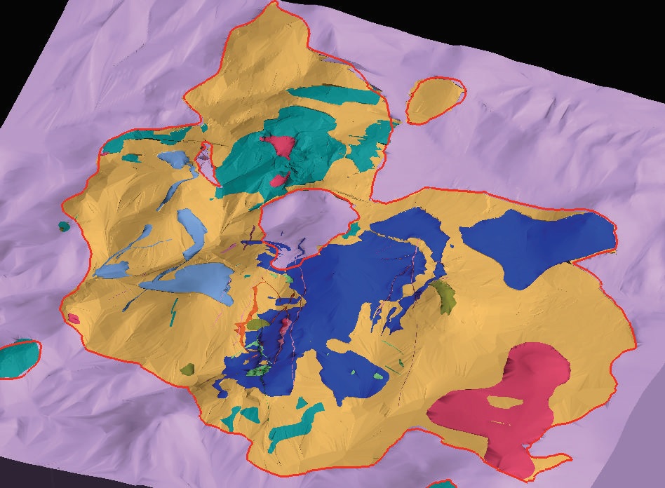
The image below shows a perspective view of the geologic model that is approximately 4 miles north-south (towards top of image), 4.3 miles east-west, and 5,000 feet thick. The central portion of the image, outlined in red, shows rocks of the diatreme-intrusive complex that have erupted through and intruded into the Precambrian basement rocks that are shown in lavender. Drill holes, geophysical data, underground workings, block models, and air photos can all be displayed and used to generate and evaluate exploration targets.
September
Resource Constraints on Alternative Energy Development: An Update
James Burnell, Colorado Geological Survey
Jim Burnell is a Minerals Geologist with the Colorado Geological Survey and a councilor of the Colorado Scientific Society.
Abstract: Public support is growing for the development of energy generation from renewable sources. However, an aspect of renewables that is unknown by many is the “hardware needs” for these technologies. The infrastructure requires mined materials, including imported strategic and critical minerals. Silica, copper, gallium, indium, selenium, cadmium and tellurium are required for the dominant photovoltaic technologies. Silver and aluminum are necessary for “concentrating solar power” technology. Zinc, vanadium, platinum group metals, and rare earth elements are key components of power storage, hybrid vehicle, and fuel cell applications. All these materials must be mined. At present, the U.S. is woefully dependent upon import sources for most of these materials and demand is already squeezing the prices. The development of domestic sources is an important step toward increased utilization of alternative energy.
Historic Mining Maps
Christopher J.J. Thiry, Colorado School of Mines Arthur Lakes Library
Abstract: One of the driving motivations of the U.S. settlement of the Rocky Mountains was mining. The gold, silver and other minerals attracted fortune seekers from around the world. Beginning in the late 1850’s, prospectors flocked to Colorado. As government organizations helped settle the lawlessness of the mining district, the need to accurately determine who had the rights to particular plots of land became necessary. At first, maps played an integral part of resolving who owned what. Later maps were used by people and companies to flaunt their claims and potential for resources and riches. Also, maps showed safety and workings features of mines. All along, maps inadvertently painted a picture of mining’s booms and busts, noted prospectors’ names, and showed the development of many of Colorado’s famous mountain towns. Today, historians use mining map for all those things previously listed, but also as ways to reconstruct timelines and add background to biographies. On top of that, some of the original maps are works of art. This talk will illustrate Colorado’s historical mining maps using the rich collection of the Arthur Lakes Library at the Colorado School of Mines.
Biography: Chris Thiry has worked for the past 14 years as the map librarian at the Colorado School of Mines Arthur Lakes Library. He oversees a 210,000+ map collection. In addition to day-to-day collection development and maintenance, reference services, and cataloging, Chris has library research interests that include topographic maps, and historic mining maps.
October; An Evening to Honor Glenn Scott
Family Tree of Soil – Geomorphic Work in the Colorado Front Range and Piedmont
Peter Birkeland, Emeritus, University of Colorado
Abstract: The history of USGS soil-geomorphic work in the area starts with the Military Geology Unit of the USGS in WWII. Charles Hunt, Roger Morrison, and Gerald Richmond came out of the unit with an appreciation for the use of soils in surficial mapping. Glenn Scott and many others used soils to aid in the mapping of surficial deposits in piedmont quadrangles. But it was Scott who formalized the stratigraphic units and related them to major climatic change, and whether or not the source watersheds were glaciated. This was one of the first uses of soils to estimate ages of alluvium and for unit correlation. Subsequently, Morrison and Richmond led a long effort to allow soils in the stratigraphic code. Dwight Crandell introduced me to soils in the 1960s, and this eventually led to a separate CU branch of the family tree. Because of all of this high-quality work, we have as good an idea of soil-geomorphic relations there as in any mountain-plains transect. More recently, soils have been used to estimate erosion rates on Scott’s Tertiary erosion surface west of Boulder, and when compared to canyon incision rates, relief could be increasing. For the future, this work and that of other USGS soil-geomorphologists nationwide has demonstrated that soils should be an important component of many USGS projects (surficial mapping, investigating paleoclimate, earth surface processes, etc.) across the United States.
Pitfalls of Interpreting Quaternary Geologic History from Alluvial Deposits in Piedmont Regions with Special Reference to the Colorado Piedmont
Rich Madole, USGS scientist emeritus
Abstract: Quaternary alluvial deposits on terraces, fans, and pediments, particularly in piedmont regions, have a long history of study for various reasons including natural hazards (floods and debris flows), gravel resources, suitability for urbanization, and because they are sources of information about recent tectonic and climate-change history. The surficial geology of the Colorado Piedmont has been studied in more detail than that of most piedmont regions; much of it has been mapped at a scale of 1:24,000. The Quaternary stratigraphic nomenclature initiated in the Denver area by Charles Hunt (1954) and expanded by Glenn Scott (1960, 1962, and 1963) has been applied throughout the Colorado Piedmont, and also has been extended to other regions in and near the southern Rocky Mountains. In several areas, the Scott nomenclature has been misapplied because of the fallibility of correlating middle and early Pleistocene alluvial deposits by height above stream level. In some cases, bedrock geologists followed the lead of Quaternary geologists who had little choice but to use height above stream level because numerical ages were lacking and exposures of tephra, primarily the Lava Creek B ash, are rare. Thus, this talk will focus on the fallibilities of such correlations. Specific topics include the nature of piedmont regions, factors controlling stream incision, and examples of how and why correlation based on height above stream level may err. Also, the use of alluvium-covered surfaces as indicators of tectonism and climate change will be discussed along with related complications such as stream piracy, stream avulsion, and topographic inversion.
December
2009 Colorado Scientific Society President’s Address
Great Basin geology, hydrology and the Colorado Scientific Society
Don Sweetkind, U.S. Geological Survey
Abstract: Geologic and geohydrologic studies in support of issues of National significance such as nuclear testing, nuclear waste isolation, and groundwater availability have resulted in fundamental advances in geological sciences in the eastern and southern Great Basin. Colorado Scientific Society members have made key advances in regional stratigraphy, caldera-related volcanism, structure, and regional tectonics. These scientific advances often came while working under tight deadlines and for cooperators that demanded information, not research.
Geologic work at the Nevada Test Site (NTS) began in earnest when testing moved underground in 1963, putting a premium on knowledge of subsurface geologic conditions for the purposes of blast containment. Mapping of numerous geologic quadrangles and subsequent compilation at smaller scales document advances in understanding of stratigraphy and structure of Paleozoic rocks and overlying volcanic rocks associated with the southwestern Nevada volcanic field. The NTS nuclear legacy includes two underground tests conducted in Colorado.
Geologic work as part of the Yucca Mountain site characterization included regional structural and tectonic studies designed to understand potential earthquake magnitude and recurrence intervals and age of volcanism at the site. Site-specific geologic studies were keyed to the near-field geologic environment and to the design and construction of underground facilities. Numerous Colorado Scientific Society members provided key scientific contributions to the understanding of the Yucca Mountain site.
A number of regional hydrologic studies have been conducted in part to evaluate the fate (flow paths and travel times) of radionuclides from underground testing areas at the Nevada Test Site and possible future effects of the potential high-level nuclear waste repository at Yucca Mountain, Nevada. These studies require broad knowledge of subsurface stratigraphy and structure sufficient to construct numerical 3-D framework models that serve as the primary geologic input to flow and transport models.
In recent decades, population growth in southern Nevada has put more pressure on available water resources from the allotted withdrawals from the Colorado River, forcing water purveyors to consider large-scale groundwater pumping interbasin diversions. The presence of large-volume springs attest to a significant regional groundwater system. Increased pressure on existing water resources in this arid region come from continued population growth, pressure for economic development, and potential new water uses related to solar energy development. These factors place a premium on understanding subsurface geology and geologic controls on regional groundwater flow.