January
Colorado’s stratigraphy: eloquent testimony to Earth’s history
Robert G. Raynolds and James W. Hagadorn, Department of Earth Sciences, Denver Museum of Nature & Science, 2001 Colorado Blvd, Denver, CO 80205.
Abstract:
New tools allow more coherent presentation of Colorado’s stratigraphic record. At Coloradostratigraphy.org we have worked with the community to assemble a large amount of material on Colorado’s stratigraphy, paleogeography and resource distribution patterns.
Our stratigraphic story divides Colorado into four styles of sedimentation: passive margin sequences (Larry Sloss was here), tectonic basins (subsiding basins bounded by active faulting, transpressive, compressional and extensional), a foreland sag basin, and strata accumulated during times of stasis. The few stratal successions that don’t fit in these categories are unusual and of particular interest; for example Colorado’s earliest sedimentary rocks are clastic dikes in the Front Range crystalline rocks. These dikes are interpreted as Neoproterozoic relicts of strata that are completely eroded today.
Times of stability are marked by healing of landscapes, peneplanation of mountains and filling of basins. Low relief (but not flat) landscapes are loci of sedimentation in absence of accommodation.
Starting in the Miocene the entire region was uplifted. Rivers draining Colorado eroded head-ward into the low relief terrain, sculpting the dramatic landscapes we enjoy today. This erosion continues to the present day.
By plotting the broad scale patterns of stratigraphy across Colorado’s varied depositional basins, we have identified a variety of correlation challenges and opportunities. Improved geochronology using new techniques such as single crystal zircon chronology and isotope chemostratigraphy offers a ripe future for recognizing new patterns in old strata.
For example, the Devonian Dyer Formation of west-central Colorado is spectacularly exposed in the Glenwood Canyon area and spans one of the most enigmatic mass extinctions in earth history – the end-Devonian event. Whereas the Dyer is known for its diverse invertebrate and vertebrate assemblages, its geochronology and facies are poorly constrained. Recent chemostratigraphic analyses reveal that a regionally extensive 13Ccarb excursion exists in the upper member of the Dyer. This excursion is interpreted to represent the Hangenberg isotopic excursion, hypothesized to be the signature element of the end-Fammenian extinction. New biostratigraphic work in the Dyer, based largely on conodonts preserved in fish fecal pellets, supports this interpretation, and demonstrates that the upper Dyer, as well as the overlying Gilman Sandstone, were deposited during the Early Carboniferous. The extinction interval in the Dyer is immediately underlain by a firm-groundlike
facies which bears abundant rugose corals. Elsewhere in the world, such fossils have been interpreted to represent Lazarus taxa that return after near-decimation at the end-Frasnian extinction. Together, these suggest that the Dyer is younger, and potentially more globally relevant, than previously thought.
Speaker Bios:
Bob Raynolds is a Research Associate at the Denver Museum of Nature & Science. Bob earned his Master’s in Applied Earth Sciences from Stanford University and his PhD from Dartmouth College. His dissertation focused on sediments that accumulated at the foot of the Himalayas. This experience led him to study comparable rocks in the Denver Basin that record the uplift of the Laramide Front Range and contain precious groundwater. Bob has worked on the Rift Valley in East Africa and on the eastern plains of the Andes. Bob has taught as a Fulbright professor at the Center for Excellence in Geology at Peshawar University in Pakistan, at Dartmouth College, and at the Colorado School of Mines where he is currently an adjunct faculty member in the geophysics department. His recent lectures focus on the impact of climate change on Colorado’s ecology and water resources of the Colorado River system.
James Hagadorn is currently the Tim and Kathryn Ryan Curator of Geology at the Denver Museum of Nature & Science. Everything about “deep time” fascinates him, and he has spent the last twenty years studying modern and ancient environments all over the world. Much of his research has focused on the latest part of the Precambrian (700-542 million years ago) and the early parts of the Paleozoic (542-450 million years ago), intervals of time that witnessed some of the most profound changes in environments and biota in all of earth history. Through fieldwork, labwork, and collaboration with academic and citizen scientists, he has studied ancient sedimentary environments, large volcanic deposits, weird minerals, extinct creatures, and a variety of enigmatic ‘whatsits’. Although this work contributes to improving our understanding of ancient earth systems, Hagadorn is cognizant of the need to leverage our understanding of ancient earth to better understand future earths.
February
The Weird and Wonderful Geology of Pluto and its Moons
John Spencer, Southwest Research Institute, Boulder CO
Abstract: In July 2015, the New Horizons mission gave us our first detailed view of the Pluto system after a 9.5 year journey from Earth. New Horizons revealed that Pluto’s geology is complex and remarkably diverse. Ancient cratered and fractured terrain is interrupted by much younger features that may be active to the present day, including rugged ice mountains, a vast plain of volatile ice, and other features that defy explanation. Pluto’s big moon Charon also has a geologically varied surface, and its four small moons have surprises of their own. The talk will describe the mission, what we’ve learned, and the spacecraft’s continuing journey into the Kuiper Belt.
Biography: John Spencer is an Institute Scientist at the Southwest Research Institute in Boulder. He obtained a BA in Geology from the University of Cambridge in 1978, and a PhD in Planetary Sciences at the University of Arizona in 1987. He then worked at the University of Hawaii and Lowell Observatory in Arizona, before joining Southwest Research Institute in 2004. His primary interest is in the moons and other small bodies of the outer solar system. He has served on the science teams of the Galileo Jupiter Orbiter and Cassini Saturn Orbiter, and is deputy leader of the geology and geophysics team on the New Horizons Pluto mission.
March
New Hominid Discoveries from South Africa, the ‘Cradle of Humankind’:
The Anthropological Significance, the Cave Geology, and How Google Earth Contributed to the Discovery
Charles Musiba, University of Colorado-Denver
Abstract: The increased use of Google Earth in the field of paleoanthropology has transformed the way paleoanthropologists conduct their field survey for new sites. Recent discovery and naming of Homo naledi from the Dinaledi chamber in the Rising Star Cave System in South Africa offers us new information on the evolution of the genus Homo in a way that is challenging us to reconsider what we know about our place in nature. The Dinaledi hominins are perhaps the most spectacular find the field of paleoanthropology has so far produced; their remarkable preservation, depositional history, and morphological features provide us with some information that is helping us understand our complex evolutionary journey. Here I will share with you my personal reflection on the discovery and research on the Dinaledi hominins, and how technology and social media is helping reshape the field of paleoanthropology. Additionally, I will also provide you with a glimpse of other equally important paleoanthropological discoveries of additional hominin footprints from Laetoli in Tanzania.
Biography: Charles Musiba (PhD) is an associate professor of biological anthropology in the department of anthropology at the University of Colorado Denver. He is a native of Tanzania, born on the shores of Lake Victoria in Mwanza town where he attended primary and secondary school education before pursuing his undergraduate studies at the JW Goethe University in Frankfurt, Germany (1985). After completion of his undergraduate training, Charles returned back to Tanzania and worked as an assistant conservator of Antiquities in the Department of Antiquities in the Ministry of Natural Resource and Tourism until 1986 when he was awarded a two years Demokritos Foundation fellowship to join the Anthropological Museum of Xanthi as a research fellow followed by a master’s degree in human ecology at the Free University of Brussels in Belgium in 1991. Charles passion has always been in prehistory, especially biological anthropology and as a result he received his second master’s degree in biological anthropology in 1996 followed by a Ph.D. in 1999 from the University of Chicago.
Charles is a paleoanthropologist who has worked extensively at Olduvai Gorge and Laetoli in northern Tanzania since 1999. His research work on human origins focuses on reconstructing pastenvironments (3.5 – 4.0 million years ago) using proxy data. He is actively involved in conservation and sustainable use of paleoanthropological resources not only to a small select group of people but to everybody in the world through education and cultural exchange programs. His previous work includes the evolution of upright posture and bipedal gait in humans with particular emphasis on the interpretation of the 3.5 million years old fossil hominid
footprints from Laetoli in northern Tanzania.
April
Tempest at Teapot Dome, Wyoming: the Greatest Political Scandal in the History of the American Oil Industry
Matt Silverman, Exploration Manager and Robert L. Bayless, Producer
No abstract or speaker biography
The Society’s 2016 annual S.F. Emmons Lecture:
The Quest for the Only Known Natural Quasi-crystal
Dr. Lincoln Hollister, Princeton University, Professor Emeritus.
Abstract: “Quasicrystals are solids with forbidden symmetry. This new form of matter was first hypothesized to exist some 30 years ago, and was later found in synthetic compounds. In 2008, the first natural quasicrystal was discovered at the Mineralogy Museum in Florence. Later, we found that the sample containing the quasicrystal came to earth on a meteorite (a CV3 carbonaceous chondrite) that landed in far eastern Russia about 8000 years ago. The Russian prospector who found this sample in 1979 took us to the site in 2011 where we found more.
“The metal alloys in the meteorite, including the quasicrystal icosahedrite, contain Cu, Al, and Fe. In the new samples we also found a second quasicrystal; it has10-fold symmetry (decagonite).
“Except in our sample, metallic Al bearing compounds have not been found on earth or in meteorites, nor do Cu and Al occur together. We are still working to understand how these ‘impossible’ samples formed.
“New results indicate that a chunk of Cu-Al-Fe metal had impacted a carbonaceous chondrite in outer space. Oxidation-reduction reactions occurred between impactor and target, and both were quenched together, preserving the reactants and the products of the reactions. The origin of the first Cu, Al, and Fe mix remains a mystery, but it probably involved a highly reducing nebular process.” (Lincoln Hollister)
May
Older than the hills: The ca. 3920-3960 Ma Acasta Gneiss (Northwest Territories, Canada
Stephen Mojzsis), Professor of Geology, and Director, Collaborative for Research in Origins (CRiO), Department of Geological Sciences, University of Colorado, Boulder
Abstract: The starting point for my presentation is the notion that conditions at the surface and interior of the Hadean Earth before about 3.9 billion years ago – which nurtured life’s origin – were different from those at present, but for reasons that are as yet poorly understood. The young Sun was dimmer, Earth’s mantle hotter, its atmosphere anoxic, and bombardment by asteroids and comets frequent, but it is unknown how such differences influenced the way the “Early Earth” functioned. By some accounts, the late Hadean (ca. 4.25-4.0 Gyr ago) may have witnessed the emergence of the biosphere from the ruins of planetary-scale bombardment. Hence, with regards to actually defining what early terrestrial environments existed that could have led to biological systems, it is mystifying that a number of fundamental aspects of the primordial Earth environment are still under debate, such as: (i) what were the thermal consequences of late accretion events like the late heavy bombardment (LHB) to the earliest biosphere?; (ii) was emergent (a.k.a. “dry land” or subaerial) land present that helped facilitate prebiotic chemical reactions that led to the origin of life?; (iii) what was the mantle’s redox state; and (vi) what was the composition of the first crust? Paradoxically, an acute inconsistency exists between observations of the natural world and the various prebiotic experimental models put forth with well-meaning assumptions about “plausible prebiotic conditions”. Such a conflict between observation and experiment can best be overcome by geology. I will show how the oldest rocks and minerals are being used to shed unprecedented light on the conditions wherein life emerged on Earth.
Biography: Steve Mojzsis is Professor of Geology at the Department of Geological Sciences, University of Colorado at Boulder where he directs the Collaborative for Research in Origins (CRiO) funded by the John Templeton Foundation-Ffame Origins program. He is also a Distinguished Visiting Professor at the Hungarian Academy of Sciences in Budapest, and has held visiting academic positions in France at the Université Claude Bernard Lyon 1, and the Centre de Recherches Pétrographiques et Géochimiques (CRPG) in Nancy, and in Japan at the Earth-Life Science Institute (ELSI) at the Tokyo Institute of Technology. His research seeks to understand the physical and chemical conditions on planets that lead to emergence of a biosphere.
September
Student Presentations Night
Our September 15 Student Night program was a great success, with good attendance, 6 oral and 8 poster student presentations, and great refreshments, including the keg of ale donated by Golden City Brewery!
Evan Jones, PhD candidate at Colorado School of Mines, received our “People’s Choice” award for the best oral paper presentation, for his talk, The Size of the California Paleoriver and its Termination in the Wasatch Fluvial Fan System: Implications for the Early Eocene Paleogeography of the Western Colorado Plateau
October
Climate Change, Part I, A Geologist’s View
William W. Little, Professor of Geology, Brigham Young University-Idaho, Rexburg, Idaho
Abstract – click the talk above for an extended abstract
Biography: William W. (Bill) Little is a sedimentary geologist with 20+ years experience in sequence stratigraphy, interpretation of clastic depositional systems, stream table analysis of fluvial systems, and both bedrock and surficial materials field mapping. He holds a Ph.D. in geology from the University of Colorado – Boulder, served as the Director of the Surficial Materials Mapping Program at the Missouri Geological Survey, and is now employed as the principal sedimentologist/stratigrapher and field camp director for the Department of Geology at Brigham Young University – Idaho and is owner of W.W. Little Geological Consulting, LLC.
Climate Change, Part II: Models, Uncertainty, Data, and Predictions – or “Why Climate Models are Like Sausages”
Thomas R. Fisher, CEO, Escalante Mines Inc., Evergreen, Colorado
Biography: Thom Fisher is a graduate in geology from the University of New Mexico, pursued his Masters and Ph.D. at the Colorado School of Mines, and is a Registered and Licensed Professional Geologist. He currently serves as Chief Executive Officer and Chairman of Escalante Mines Inc., a Colorado Corporation engaged in mineral and energy exploration and development in the Western U.S. and internationally. He additionally serves on boards of directors of several other Colorado-based companies.
Academically, Thom has achieved international recognition for his pioneering work in computer-based multidimensional geoscientific modeling methods and systems. He has served as lecturer in the topic at the Polish Academy of Mining and Metallurgy (Stanislaw Staszic University of Mining and Metallurgy), and the Polish Academy of Sciences – Institute of Geological Sciences, Krakow, Poland; the European Science Foundation; and workshops for the Gustav Stresemann Institute, Bonn, Germany. He has also served as an industry advisor to the Energy and Minerals Advanced Research Center (EMARC), University of Colorado Boulder; the Petroleum and Geosystems Engineering Laboratory, New Mexico Tech, Socorro; and the Bureau of Economic Geology, University of Texas, Austin.
His primary interests lie in stratigraphy and sedimentology, paleoclimates and interpretation of ancient sedimentary environments, geostatistics, and Markovian Processes. He specializes in multidimensional geoscience modeling and geostatistics applied to mineral deposits and oil and gas accumulations. His Ph.D. research focused on the application of sedimentological methods and advanced geostatistical modeling to West African Paleoproterozoic quartz pebble conglomerates and paleoplacers for prediction of gold deposits. This work was sponsored by Gold Fields South Africa and Gold Fields Ghana Ltd., and championed and mentored by Professor Emeritus Danie Krige, University of Witwatersrand, Johannesburg, and Professor W.E.L. Minter, University of Cape Town, Cape Town, South Africa.
Thom is the author or co-author of over 50 U.S. and internationally published professional works on a myriad of topics in sedimentology, stratigraphy, paleontology, multidimensional geoscience modeling, geostatistics, fuzzy logic, neuro-fuzzy modeling of geologic systems, climate science, and statistics. He currently serves as a member of the Editorial Advisory Board of “Computers and Geosciences” published by the International Association for Mathematical Geosciences. He is also a past Associate Editor of the professional journal “Petrophysics”, and is currently co-authoring a new textbook on ore deposit characterization and applied geostatistics with his wife, Lisa Fisher.
November
Relict Dinosaurs of Madagascar: New Discoveries from Treasure Island
Dr. Joe Sertich, Ph.D., Curator of Vertebrate Paleontology, of terrestrial ecosystems during the Mesozoic) Denver Museum of Nature & Science
Abstract: Ongoing fieldwork on the island of Madagascar over the past 23 years has revealed a stunningly preserved assemblage of dinosaurs and other animals from the Cretaceous, arguably one of the best dinosaur ecosystems ever collected from the southern hemisphere. Historic expeditions, together with recent fieldwork in 2015, have uncovered a fantastic new story of isolation and bizarre evolution on the island landmass. Despite the many trials and pitfalls of mounting expeditions to Madagascar, one of the most remote and biodiverse places on Earth, paleontologists continue to be rewarded with spectacular fossils of bizarre crocodiles, strange birds, giant frogs, and dinosaurs. New and continuing work to uncover the origins of these beasts, together with the move of these fossils and research responsibilities to the Denver Museum of Nature & Science, have placed Colorado at the center of paleontological investigations into the island of Madagascar.
Biography: Joe Sertich is Curator of Dinosaurs at the Denver Museum of Nature & Science. He received his B.S. in from Colorado State University in 2004, his M.S. at the University of Utah in 2006, and his Ph.D. from Stony Brook University in 2011. His research focuses on dinosaurs, crocodiles, and flying reptiles, and their ecosystems, during the Late Cretaceous. His field-based research is split between the Gondwanan continents of the southern hemisphere and western North America. He is one of the primary researchers on the Madagascar Paleontology Project exploring the latest Cretaceous of Madagascar and has expanded the search for dinosaurs to older deposits across the island. He is also working on several projects searching for the first latest Cretaceous dinosaurs of Africa, including work in northern Kenya and Egypt. In North America, he leads the Laramidia Project, currently leading work to uncover a lost world of dinosaurs in the Cretaceous of Grand Staircase-Escalante National Monument, Utah, northwestern New Mexico, and northwestern Colorado.
December
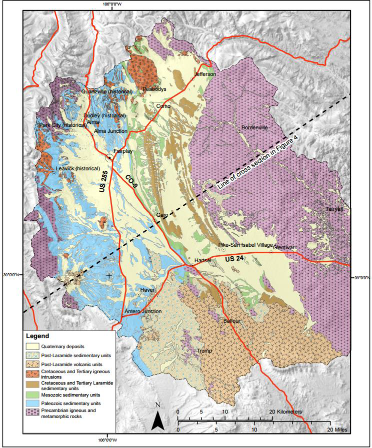
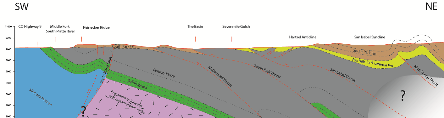
Presidential Address: South Park: Recent investigations by the Colorado Geological Survey carry on a legacy of geologic mapping in a fascinating setting
Peter Barkmann, Colorado Geological Survey
Abstract: In addition to being one of Colorado’s scenic and historic gems, South Park is an amazing place to study geology. This geologic wonder has captured the imagination of geologists for over a century as many bright minds have worked to unravel its many elusive secrets; so much more remains to be solved. Strata and structural features record a long, complex progression of tectonic events through an ever-changing geographic setting. The structural basin preserves marine and non-marine sediments deposited in many of Colorado’s more interesting geologic phases, including the late Paleozoic Ancestral Rocky Mountains orogeny, Cretaceous Interior Seaway foreland basin event, Laramide orogeny, Paleogene and Neogene volcanic flare-up, and the recent Rio Grande rift extensional event. Topping off all of that are spectacular Quaternary glacial and periglacial features within, and surrounding, the basin.
Recent geologic mapping at a 1:24,000 scale by the Colorado Geological Survey and United States Geological Survey bring to light complexities in the basin’s stratigraphic record and structural fabric. A legacy of subsurface data from decades of oil and gas exploration add three-dimensional insight of the deeper structural patterns. Strata preserved in the basin include Pennsylvanian-Permian synorogenic sediments deposited in the Central Colorado Trough as the Ancestral Rocky Mountains evolved. This nearly 10,000 foot thick sequence includes ductile and soluble evaporitic facies that certainly affected later deformation even up to the Holocene. The post-ancestral Rocky Mountain landscape was beveled and subsequently blanketed by Jurassic and Cretaceous sediments, including the marine strata of the Interior Seaway. Deformation during the Late Cretaceous to Eocene Laramide orogeny compressed these strata into a complex series of folds combined with reverse and thrust faults. Deposition of thousands of feet of synorogenic fluvial sediments accompanied this deformation and record un-roofing of differing highlands.
The Hartsel Quadrangle is the most recent quadrangle to be mapped by the CGS as part of the National Cooperative Mapping Program STATEMAP effort. Field work completed during the summer and fall of 2016 has added great detail to the bedrock and Quaternary geologic story of this critical area. At the time of this abstract, data are still being compiled and analyzed, but the information gathered so far shed new light on stratigraphic and structural relationships from both the Ancestral Rocky Mountain Laramide tectonic events.
Not only does the quadrangle sit at the geographic center of the basin, it is a nexus of major structural boundaries that define distinct blocks. One block is the prominent northwest-trending Precambrian basement cored Hartsel uplift, while a second, Paleozoic sediment-cored block, meets it just to the north across a major fault. Mapping has help delineate the edge of the Central Colorado Trough along the Hartsel block with evidence of fault boundaries, on-lap relationships, and proximal fan facies. The quadrangle also straddles a complex belt of deformation characterized by primary low angle west-directed thrust faults. This belt includes the Hartsel anticline, which appears to be flanked by east-directed back-thrust faults. A series of northeast trending compartment faults segment this belt. Stratigraphic relationships within the synorogenic South Park Formation point two a progression of early deformation and un-roofing to the west followed by subsequent deformation and un-roofing to the east. The later west-directed thrust faults appear to converge upon the previously uplifted Hartsel block, suggesting a constriction of the compressional deformation against the rigid earlier uplift. The earlier uplift may have acted as a buttress complicating the deformation patterns.
Detailed mapping of the synorogenic South Park Formation reveals changes in source areas from a volcanic highland to the north-northwest through to a basement-cored highland to the west. The Link Springs Tuff Member, previously limited to a belt further to the north, now appears to continue to the southern extent of the South Park Formation. This distinctive unit forms a marker bed useful for defining subtle structures. Mapping has also delineated a new member, informally called the Santa Maria member, which includes nodular calcareous red-beds and distinct beds of conglomerate containing rip-up clasts of algal limestone. Aspects of this unit beg for better definition.
The quadrangle also includes a complex Tertiary (?) mafic intrusion that forms a layered sill within the Fox Hills Sandstone fed by a network of dikes. Outliers of Eocene (?) andesite and Wall Mountain Tuff dot the southern edge of the area. Quaternary features include abandoned Late Pleistocene river valleys, fossil solifluction features, and possible relict ice wedges. There really is something for everyone in South Park!
Figure 3, from South Park, Colorado: The interplay of tectonics and sedimentation creates one of Colorado’s crown jewels, by, Peter E. Barkmann, Edward J. Sterne, Marieke Dechesne, and Karen J. Houck; pp. 151-190 in Keller, S.M., and Morgan, M.L., eds., Unfolding the Geology of the West: Geological Society of America Field Guide 44 (2016).