January
An Arctic Perspective on 20th Century Warming
Dr. Gifford Miller, INSTAAR and Geological Sciences, University of Colorado, Boulder
Abstract: As the planet has warmed over the past century, Arctic temperatures have increased at 2 to 3 times the global rate, with documented reductions in sea ice, glacier size, and snowcover, reflecting the strong positive feedbacks operating in the polar regions. However, the extent to which recent Arctic warming has been anomalous with respect to long-term natural climate variability remains uncertain. We use radiocarbon measurements on rooted tundra plants exposed by recent ice-cap retreat to provide a millennial perspective on summer temperature change. Over 300 14C dates on plants entombed beneath ice in Arctic Canada demonstrate that 5000 years of regional summertime cooling has been reversed, with 100-year average summer temperatures now higher than during any century in more than 45,000 years, including peak warmth of the early Holocene when solar energy in summer was 9% greater than present. Our results suggest that anthropogenic increases in greenhouse gases have led to unprecedented Arctic warmth, with implications for lower latitudes through sea-level rise and changes in Northern Hemisphere atmospheric circulation.
Biography: Gifford Miller is Professor of Geological Sciences and Fellow of the Institute of Arctic and Alpine Research (INSTAAR) at the University of Colorado, Boulder, where he also serves as Associate Director. His research focuses on utilizing the record of the recent geological past, primarily in hot and cold deserts, to gain a better understanding of Earth’s climate system, and the role of humans in the Earth System. He has long-standing research programs in the Eastern Canadian Arctic, Australia, Iceland, and Svalbard.
Giff focuses primarily on the Late Quaternary, with a goal of gaining a better understanding of Earth’s climate system. His early research was dominantly in the cold deserts of the Polar Regions, with current field projects in the Eastern Canadian Arctic, Svalbard, Iceland and West Greenland, where his research group focuses on abrupt climate change and placing current summer warming in a millennial perspective. In mid-career Miller became interested in hot deserts and monsoon systems while working in North Africa. He has focused on the Australian Summer Monsoon, causes of megafaunal extinction and the footprints of human colonization in Australia for the past 25 years. Recently, his research group expanded the megafuanal extinction work to Madagascar, where he is evaluating the extinction of the Elephant Bird, Aepyornis.
February
Landscape Evolution of Colorado
Late Neogene Tectonic and Volcanic Fragmentation and Middle Pleistocene Climate-Driven Drainage Integration of the Southern Rocky Mountains
Cal Ruleman, Geology and Environmental Change, USGS
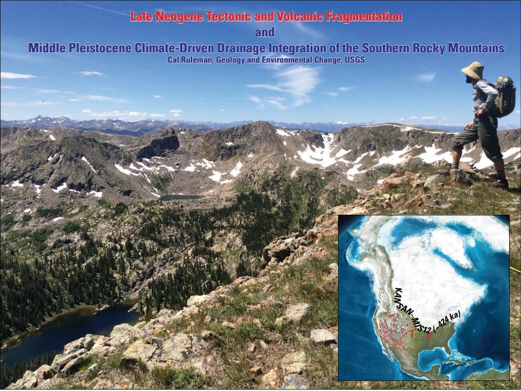
Synopsis: The southern Rocky Mountains have long been a focus for lithologic, structural, and geomorphic studies. Building on this previous work using newly developed geomorphic, chronologic, geodetic, geophysical, and pedologic analyses, I am developing a unified model to: (1) explain the timing and mechanism for regional middle Pleistocene incision; (2) determine regional correlations; and, (3) resolve discrepancies between bedrock and surficial geologists. I will highlight recent work on diamictons and Quaternary deposits in the San Luis Valley, Sawatch Range, and upper Arkansas valley. Through this work I have developed the following geomorphic sequence: (1) deposition of extensive Rocky Flats-correlative alluvium on adjacent Rocky Mountain piedmonts and continued tectonically-induced aggradation within Rio Grande rift basins (>640 ka); (2) eruption of the Lava Creek B tephra at ~640 ka; (3) subtle landscape dissection and deposition of inset Verdos-correlative alluvium (~621-478 ka); (4) San Luis basin spillover and integration into Rio Grande and widespread deposition of diamicton on Poncha Pass and around the perimeter of high altitude mountains (478-374 ka); and, (5) intermountain deep-canyon incision and adjacent Front Range and San Juan Basin piedmont incision and widespread deposition of Slocum-correlative alluvium on flanking piedmonts (~374-191 ka). All younger deposits and landforms are deeply inset into the topography and easily distinguishable.
Full Abstract:The southern Rocky Mountains have long been a focus for lithologic, structural, and geomorphic studies. Building on this previous work using newly developed geomorphic, chronologic, geodetic, geophysical, and pedologic analyses, I am developing a unified model to explain the timing and mechanism for regional middle Pleistocene incision, determine regional correlations, and resolve discrepancies between bedrock and surficial geologists. Recent work within the San Luis Valley, Sawatch Range, and upper Arkansas Valley demonstrate a linkage between the Lake Alamosa highstand ~385 ka, maximum basin fill elevation, and deposition of the first Pleistocene diamicton above generally finer-grained deposits of the Santa Fe Group and Dry Union Formation. These boulder diamictons have been previously mapped around the region as QTd or Tg (Quaternary-Tertiary diamicton or Tertiary gravel) depending on the breadth of geologic time the author was familiar with and focusing on. They were also generally interpreted to be the result of rapid tectonic uplift. The presence of ~640 ka Lava Creek B ash in the underlying, lower-energy deposits of the Santa Fe Group provides a maximum age for the diamicton and indicates a <640ka dramatic change in the basin-fill sedimentology leading to deposition of coarse axial gravels linking previously closed, and disconnected intermountain basins adjacent to the high elevations. We interpret these sedimentologic and geomorphic relationships to indicate the regional onset of major middle Pleistocene glacial episodes younger than MIS 16, ~676-621 ka. Within the San Luis Valley, maximum aggradation elevation, basin integration processes, and incision into the Rio Grande gorge occurred even later, <420 ka (MIS 12), coeval to placement of the first diamicton on Poncha Pass. Poncha Pass is where intermountain tectonically-fragmented basin stratigraphy meets the Front Range piedmont Pleistocene stratigraphy along the Arkansas River and through the Royal Gorge. Regional geologic mapping and topographic correlations demonstrate that similar relationships (i.e., coarse bouldery deposits with a silty clay matrix capping interfluves and overlying/pre-dating deeply incised topography) exist in the Aspen region and across South Park, along the Black Canyon of the Gunnison and Eagle River, and potentially adjacent to any region above 3600 m (~12,000 feet).
The geomorphic sequence is as follows: 1) deposition of extensive Rocky Flats-correlative alluvium on adjacent Rocky Mountain piedmonts and continued tectonically-induced aggradation within Rio Grande rift basins (>640 ka)(>MIS 16); 2) eruption of the Lava Creek B tephra from the Yellowstone caldera complex ~640 ka; 3) subtle landscape dissection and deposition of inset Verdos-correlative alluvium containing Lava Creek B ash on piedmonts (i.e., Front Range/Denver , San Juan, Wind River, and Bighorn Basins)(~MIS 15-13, ~621-478 ka; 4) San Luis basin spillover and integration into Rio Grande and widespread deposition of diamicton on Poncha Pass and around the perimeter of high altitude mountains (MIS 12-11, 478-374 ka); 5) intermountain deep-canyon incision and adjacent Front Range and San Juan Basin piedmont incision and widespread deposition of Slocum-correlative alluvium on flanking piedmonts (MIS 11-7, ~374-191 ka). All younger deposits and landforms are deeply inset into the topography and easily distinguishable. Coeval to glacially-induced middle Pleistocene Southern Rockies incision, Great Plains neotectonics and the evolution of the Arkansas River-Sand Creek-South Platte fluvial system can be directly related to the timing of Laurentide “Kansan” glaciation, the southernmost and most expansive Laurentide icesheet during the Pleistocene. Tentative correlations suggest that Front Range Bear and Clear Creek drainages have the same geomorphic sequence, explaining peculiar deposits and geomorphic relations between Green and North and South Table Mountains and the Continental Divide.
Biography: Cal Ruleman studied geology at the University of Montana and Montana State University and has been performing geological investigations for the last twenty years in various tectonic and geomorphic settings including Montana, Idaho, Wyoming, Nevada, Colorado, New Mexico, Alaska, Suriname, South America, Afghanistan, and Nepal. He joined the U.S. Geological Survey in 2007. His work has ranged from Archean to Holocene with a focus on geomorphology and landscape evolution. In addition to geologic mapping, paleoseismology, and geomorphic analyses, he employs various Quaternary relative and absolute dating techniques including pedology, 3He-, 10Be-, and 26Al-surface exposure dating, and U-Th soil carbonate dating techniques to resolve geologic problems. His geologic mapping and investigations within the Rocky Mountains from western Montana to northern New Mexico address: 1) temporal and spatial migration of intermountain neotectonics, 2) the timing and process of gorge formation and deep incision below glaciated regions, 3) timing of Last Glacial Maximum ~22 ka and rates of deglaciation, 4) timing of onset and sequence of major Pleistocene glaciations of North America, and 5) bedrock structural development of the region over multiple tectonic episodes. Building upon the lithologic, structural, and geomorphic findings of our predecessors, he combines newly developed geomorphic, chronologic, geodetic, paleoseismologic, geophysical, and pedologic analyses to develop unified models explaining the timing and mechanism for regional middle Pleistocene incision, quantifying geomorphic processes, determining regional correlations, and attempting to resolve discrepancies between traditional bedrock and surficial geologists.
=
March
The Far-Reaching Effects of Wastewater Injection: Recent Case Studies of Anthropogenic Earthquakes
Will Yeck, National Earthquake Information Center, USGS
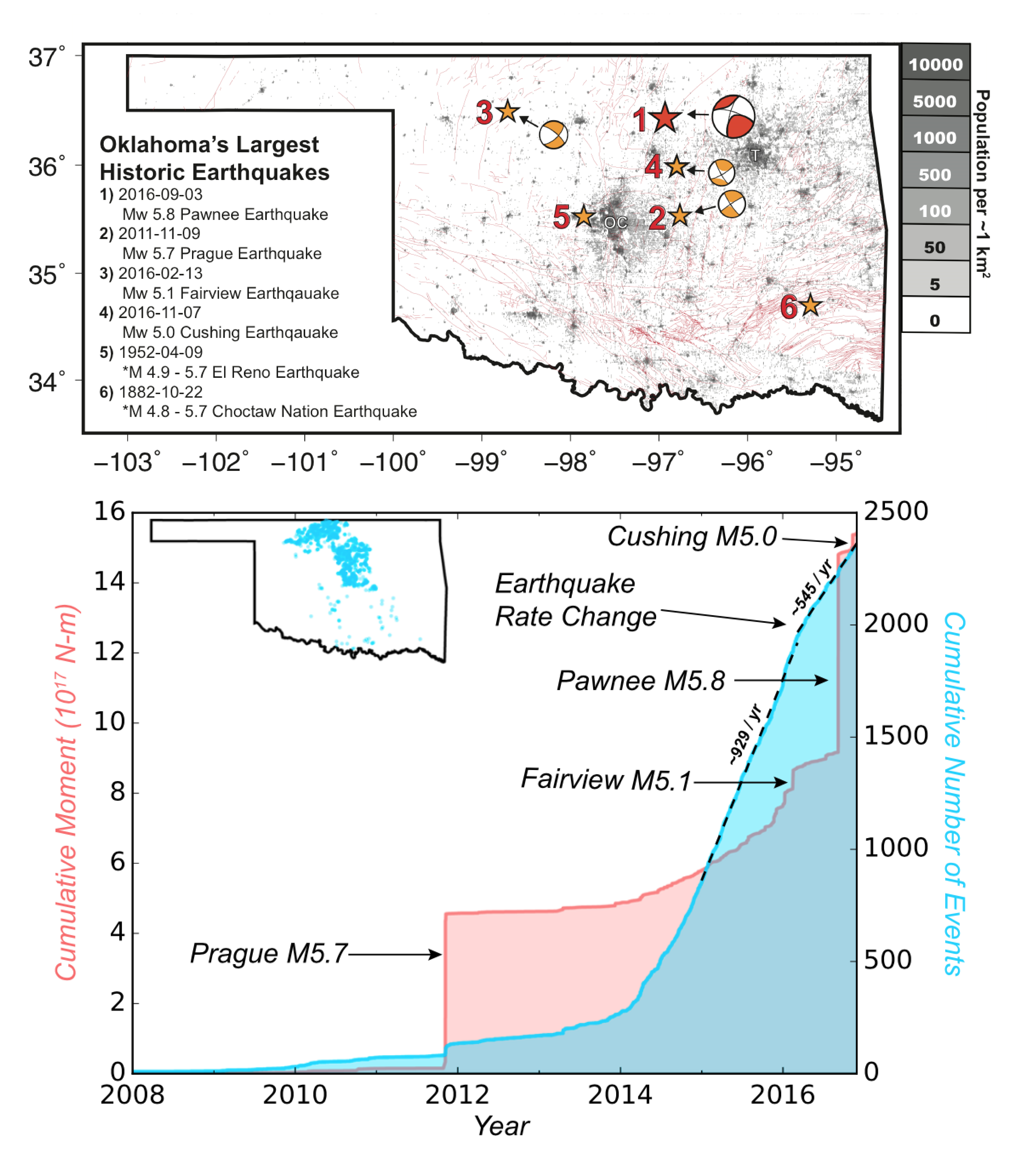
Abstract: Anthropogenic earthquakes, primarily the result of deep fluid injection, currently contribute significantly to the overall earthquake hazard in the Central and Eastern United States. While the majority of these induced earthquakes currently occur in Oklahoma, Colorado has a long record of injection induced earthquake sequences that form the basis of our broader understanding of the phenomenon. The connection between fluid injection and seismicity was first observed in the early 1960’s when a series of damaging earthquakes near Denver occurred due to the injection of waste fluids at the Rocky Mountain Arsenal. In response to these earthquakes, the USGS led an induced seismicity experiment in the late 1960’s in Rangely, Colorado, that confirmed the hypothesis that seismicity correlates with increased fluid pressure. Since 1991, the Bureau of Reclamation has been monitoring induced earthquakes associated with fluid injection at Paradox Valley and has observed earthquakes up to ~20 km from the causative well. Elsewhere in Colorado, wastewater injection has increased the rate of earthquakes in the Raton Basin since 2001, including a damaging M 5.3 earthquake in 2011. Most recently, a 2014 M 3.2 earthquake was induced by wastewater injection near Greeley, Colorado, and rapid mitigation efforts were employed to prevent continuing seismicity.
The lessons learned from the case examples of Colorado-induced earthquakes give insight into the wide-scale induced seismicity in Oklahoma. Since the early 2000s, the rate of earthquakes in Oklahoma has increased dramatically, including the occurrence of significant and damaging events. Since 2011, Oklahoma has experienced four moderate sized (M5-6) earthquakes, three of which occurred in 2016. In contrast, only two moderate sized events, in 1882 and 1952, are historically documented. Combining observations from induced earthquakes in Colorado and Oklahoma, we now have a large dataset to evaluate the effectiveness of commonly employed mitigation strategies. Key observations from moderate sized earthquakes in Oklahoma include: (1) the existence or extent of causative fault is often unknown prior to an earthquake’s occurrence, (2) induced earthquakes often occur with little to no foreshock activity, and (3) moderate sized earthquakes can occur at large distances (>15 km) from high-rate injection wells. The combination of these observations demonstrates the difficulties in mitigating associated earthquake hazards. In 2015, Oklahoma began regional mitigation strategies aimed at reducing the volume of injected fluid. The rate of earthquakes decreased in 2016 compared to 2015, which suggests that reducing volumes can reduce the earthquake rate. Still, 2016 hosted three moderate sized events and therefore had a substantially larger cumulative moment release as compared to previous years. The combination of detailed real-time monitoring, detailed source characterization research, and evaluation of yearly hazard estimates will continue to improve our understanding of the hazard presented by induced events.
Biography: William Yeck is a research geophysicist with the U.S. Geological Survey National Earthquake Information Center, located at the Geologic Hazards Science Center in Golden, Colorado. His research focuses on improved real-time detection and characterization of earthquake sources, anthropogenic seismicity within the United States, and better spatio-temporal characterization of damaging earthquake sequences for long-term hazard assessment. Will received his B.S. in Physics at the University of Wisconsin – Madison and a Ph.D. in Geophysics at the University of Colorado at Boulder. His Ph.D. research primarily addressed issues of crust and upper mantle structure and the associated kinematic evolution of the Rockies during the Laramide orogeny. During his Ph.D., Will worked at the U.S. Bureau of Reclamation studying earthquakes induced by fluid injection at Paradox Valley, Colorado.
April
Simple, Serious, and Solvable: The Three S’s of Climate Change
Scott Denning, Atmospheric Sciences, Colorado State University
Thursday, April 20, 2017
Synopsis: Simple, Serious, and Solvable: The Three S’s of Climate Change
Climate Change is Simple. Heat in minus heat out equals change of heat. When Earth absorbs more heat than it emits, the climate warms. There is no doubt that adding CO2 reduces Earth’s heat emission and therefore causes global warming.
Climate Change is Serious. In addition to more drought, a warmer climate will include heavier rainfall during extreme events. Warmer ice sheets release more water the oceans, which also expand as they get warmer. These two influences raise sea levels, threatening coastlines everywhere. Without strong policy, these impacts will become more and more severe, almost without bound.
Climate Change is Solvable. Preventing catastrophic climate change will require abundant and affordable energy to be made available to people everywhere without emitting any CO2 to the atmosphere. This will require both the development of energy efficient infrastructure and very rapid deployment of non-fossil fuel energy systems, especially in the developing world.
Abstract: Simple, Serious, and Solvable: The Three S’s of Climate Change
Climate Change is Simple. Heat in minus heat out equals change of heat. When Earth absorbs more heat than it emits, the climate warms. When it emits more than it absorbs, the climate cools. This simple principal explains why day is warmer than night, summer is warmer than winter, and Miami is warmer than Minneapolis. It also explains why adding CO2 to the air causes global warming. The absorption of thermal infrared radiation by CO2 was first measured 150 years ago, has since been confirmed thousands of times by labs all over the world, and is extremely well understood. There is no doubt at all that adding CO2 reduces Earth’s heat emission and therefore causes global warming.
Climate Change is Serious. Warmer average temperatures are associated with dramatic increases in the frequency of extremely hot weather. Warmer air evaporates more water from soils and vegetation, so even if precipitation doesn’t change the demand for water will increase with warmer temperatures. Adding water vapor to the air also means there is more water available for heavy rains when the right conditions occur: this means that in addition to more drought, a warmer climate will include heavier rainfall during extreme events. Warmer ice sheets release more water the oceans, which also expand as they get warmer. These two influences raise sea levels, threatening coastlines everywhere. Higher seas imply much more frequent coastal flooding, requiring abandonment long before mean sea level reaches coastal infrastructure. Without strong policy, these impacts will become more and more severe almost without bound, growing to become the most serious problems in the world and lasting for many centuries after fossil fuels are abandoned. The consequences of unchecked climate change to the global economy are unacceptable.
Climate Change is Solvable. Preventing catastrophic climate change will require abundant and affordable energy to be made available to people everywhere without emitting any CO2 to the atmosphere. This will require both the development of energy efficient infrastructure and very rapid deployment of non-fossil fuel energy systems, especially in the developing world. From an engineering perspective, both objectives are eminently feasible with mature technologies. Economically, the clean energy transition will be expensive, involving roughly 1% of the global economy. This cost is comparable to previous development achievements such as indoor plumbing, rural electrification, the global internet, and mobile telecommunications. Our descendants will better lives by developing and improving their infrastructure just as our ancestors did.
Biography: Professor Scott Denning received his B.A. in Geological Sciences from the University of Maine in 1984, and his M.S. and Ph.D. degrees in Atmospheric Science from Colorado State University in 1993 and 1994. He studied radiometric geochronology, surface water geochemistry, and mountain hydrology before becoming interested in global climate and biogeochemical dynamics. After a two-year postdoctoral appointment modeling global sources and sinks of atmospheric CO2, he spent two years as an Assistant Professor in the Donald Bren School of Environmental Science and Management at the University of California at Santa Barbara. He joined the Atmospheric Science faculty at Colorado State University in 1998, and has served as Director of Education for the Center for Multiscale Modeling of Atmospheric Processes (CMMAP) since 2006. He does a lot of outreach about climate change, and takes special delight in engaging hostile audiences.
May
Too Warm, Two Poles: How Past Interglacials Should Inform Future Coastal Policy
Julie Brigham-Grette, University of Massachusetts- Amherst
May 18, 2017
Abstract: Glacial and interglacial change uniquely imposed on the Bering Strait region some of the most radical changes in sea level and paleogeography documented in the Northern Hemisphere. Following the transition from a forested Arctic 3 million years ago and the first major glaciation of the northern hemisphere about 2.6 million years ago, marine deposits found along the coasts of Alaska and elsewhere record critical transitions in the evolution of Earth’s climate but especially times of high sea level. Geologic records of Plio-Pleistocene super interglacials from both the Arctic and the Antarctic show us that ice sheets are more vulnerable to subtle polar warming than once thought. Given that sea level rise today and into the near future is global and not reversible, new approaches will require social and political action aimed at short-term fixes and long-term “managed retreat” of human infrastructure from our coastlines.
Biography: Dr. Julie Brigham-Grette is professor in the Dept. of Geoscience’s Climate System Research Center at Univ. Massachusetts – Amherst. She graduated from Albion College and completed her M.S. and Ph.D at the University of Colorado, with post-doctoral work at the University of Bergen, Norway, and the University of Alberta, Canada. Julie’s research interests are focused on the stratigraphy, sedimentology, and chronology of geologic systems that record the climate evolution and sea level history of the Arctic since the mid-Pliocene. Most of her research program is aimed at documenting the global context of paleoenvironmental change across “Beringia”, stretching from Alaska and the Yukon across the Bering Sea into Russia. She was co-chief scientist of an expedition to Lake El’gygytgyn in northeast Russia that recovered an unprecedented core record of paleoclimate of the past 3.6 million years.
September
Student Paper Night
September 21, 2017
Colorado students previewed their cutting-edge research prior to the upcoming 2016-2017 conference season.
PRESENTATIONS: The oral talks were 15 minutes each, with 12 minutes for the presentation and 3 minutes for questions, as at professional meetings.
Kelly Kochanski, CU Geological Sciences Department, “The self-organization of snow surfaces and the growth of sastrugi”
Jenny Nakai, CU Geological Sciences Department (Geophysics), “A possible causative mechanism of Raton Basin, New Mexico and Colorado earthquakes using recent seismicity patterns and pore pressure modeling”
Simon Pendleton, CU Geological Sciences Department, “Testing the ice cover history of preserved landscapes on Baffin Island using 14C”
Jessica Roberts, CU Astrophysical and Planetary Science Department, “The atmospheres of two super-puffy exoplanets”
John Waida, MSU Earth and Atmospheric Sciences Department, “Feasibility of fluorescent placer diamond prospecting using ultra-violet specific longwave LED light sources”
Yalin Li, CSM Civil and Environmental Engineering, “Transformation of Wastewater Treatment- Energy and Nutrient Recovery from Municipal Wastewater”
See the CSS September 2017 newsletter for abstracts of the presentations.
The popular vote “best presentation” award went to Kelly Kochanski for her talk, “The self-organization of snow surfaces and the growth of sastrugi”.
Download the event flyer:
Colo Sci Soc September 21st Meeting – Student Papers and Posters
October
Using Geoscience to Augment Environmental Public Health Studies
Suzette Morman, Crustal Imaging and Characterization, USGS
October 19, 2017
Abstract: For many years, health studies related to the environment were sometimes limited in their focus like those in other science disciplines. For example, epidemiological studies of lung cancer in uranium mine workers in Europe and the Southwestern United States (1950’s and 60’s) concluded radioactive radon daughters were likely responsible. But these studies did not examine any possible contribution from exposure to other toxic elements present in the ore such as arsenic. The application of geoscience knowledge, methods and techniques to environmental health related studies have provided important information over the past few decades. Interdisciplinary research, more common in the past decade, is essential to solve complex environmental issues.
Biography: Suzette Morman is a geologist in the Crustal Geophysics and Geochemistry Science Center, U.S. Geological Survey, Denver. Her current research involves the interface between minerals and human health, examining concerns such as bioaccessibility and biodurability of earth materials. She uses both analytical and experimental techniques to investigate geochemical and physiological processes that play a role in the health effects of earth materials. Other interests include exposure science and natural disasters. Prior to graduate studies in geological sciences, Suzette was a nurse clinician who provided acute, chronic, and hospice care and undertook management roles as well. Thus, she is uniquely qualified to synthesize the geochemical and medical aspects of earth materials and human health. Her publications include studies on mineral dust and human health, potential health effects of folk remedies, and bioaccessibility of trace metals in mine wastes.
November
Earth’s Earliest Evolution: Fire from above, fire from below
Simone Marchi, Southwest Research Institute, Boulder
November 16, 2017
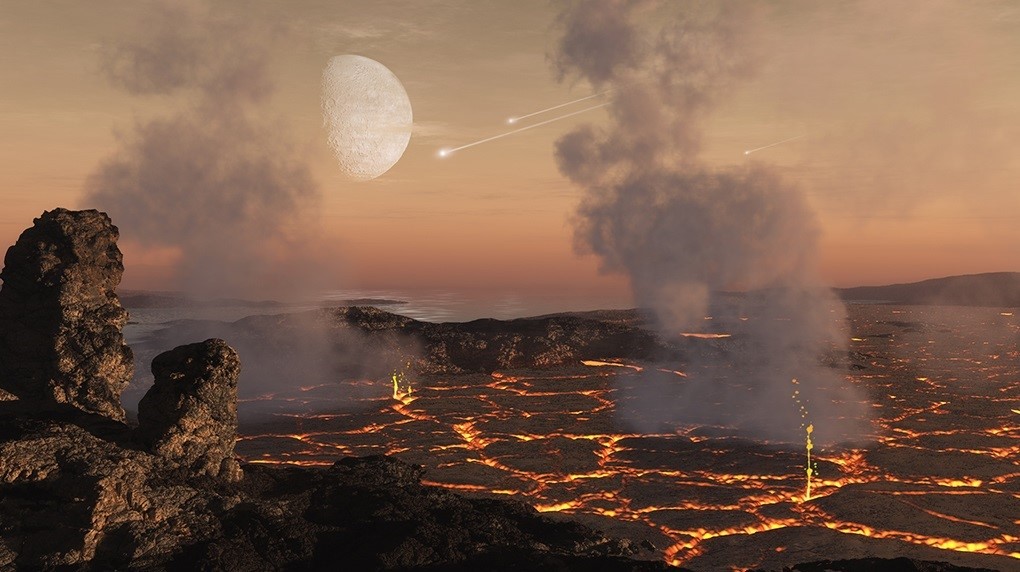
Abstract: In the aftermath of the giant collision resulting in the formation of the Moon, about 4.5 billion years ago, the Earth experienced a protracted time of bombardment by leftover planetesimals. In this talk I will present a new bombardment model of the Hadean Earth that has been calibrated using existing lunar and terrestrial geochemical data. We find that the surface of the Hadean Earth was widely reprocessed by impacts through mixing and burial by impact-generated melt. This model may explain the absence of early terrestrial rocks. In addition, by tracking the magnitude and timing of large collisions, we find that existing oceans would have repeatedly boiled away into steam atmospheres as late as about 4 billion years ago. These findings have important implications for the formation and stability of early habitable environments and the onset of life. Finally, I will discuss recent developments in understanding the effects of collisions on the tectonic evolution of the early Earth, as well as the formation of impact-induced geochemical heterogeneities that could still persist in terrestrial mantle rocks.
Short Biography:My research interests span from the formation and geology of terrestrial planets the moon and asteroids, to the spectroscopy and dynamics of minor bodies and meteorites.
I am an associate with several space missions, including: NASA’s Dawn, Lucy, Psyche, and ESA’s Rosetta, BepiColombo, JUICE.
I have been a fellow at the NASA Lunar Science Institute, the Observatoire de la Cote d’Azur, the German Aerospace Agency, and Padua University. I hold a PhD in Applied Physics from the Pisa University. More details can be found here: http://www.boulder.swri.edu/~marchi/index.html
December
DUST! Why Should You Care? (the answer is blowing in the wind)
Marith Reheis, Emeritus USGS
December 13, 2017
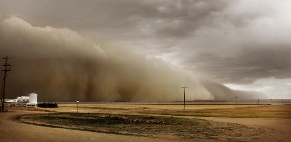
Abstract: Windblown dust is carried all over the world, whether visible or not. Earth-derived dust today is most abundant in arid and semi-arid regions, and in the glacial past in glacio-fluvial areas. So why is dust important? Let me count some of the ways: (1) agriculture, (2) ecosystems, (3) dust storms, (4) water supply, (5) human (and animal) health. Dust is the great equalizer of the Earth’s surface, because it is the only component (along with other wind-borne materials like volcanic ash and anthropogenic pollutants) that circles the planet.
Dust can be rich in mineral nutrients such as potassium, phosphorus, magnesium, manganese, copper, zinc, boron, and molybdenum. Transported dust is either deposited as a blanket (loess) or added to soils. Loess forms the substrate for the richest crop-growing areas on the planet; dust added to soils contributes critical plant nutrients that may not be available in the parent material. For instance, we now know that dust from Africa provides most of the mineral nutrients external to that held in the biomass to the Amazon rain forest. Dust forms the vast majority of silt and clay-sized particles present in desert soils and dust from distant sources is present in nearly every soil on the planet. Dust is trapped and retained by the biological crust that binds surface sediment in drylands, and thus plays an important role in dryland ecosystems.
What dust brings, it can take away in the form of blinding dust storms with consequences for agriculture, human health, and water supply. The effects of the terrible dust storms of the Dust Bowl days on soil erosion and people are well known. Exposure to excessive amounts of dust can cause asthma and silicosis and can trigger heart attacks and strokes. Dust from some soil surfaces can carry the anthrax bacterium or fungal spores that cause valley fever (coccidiomycosis). And dust from some natural sources, such as desert playas and lakes dried up due to over-use of water, can contain high concentrations of toxic elements such as arsenic, antimony, tungsten, chromium, and lithium. Ongoing studies are showing that dust, when deposited on spring snowpack, decreases reflectivity. This causes snow to melt earlier and faster, and can sharply reduce water supply in late summer and fall.
Short Biography of Marith Reheis: I graduated with a B.S. in Geology from the University of Georgia in 1972. Desperate to escape from humidity and saprolite, I earned an M.S. from the University of Colorado studying the transport of debris by Arapaho Glacier. After a few years mapping coal in the Conservation Division of USGS, I returned to CU Boulder to study soil genesis under Pete Birkeland. From 1984 to retirement in 2013, I’ve resided in the evolving branches of Regional Geology — Environmental Geology — Climate — Earth Surface Processes – Geosciences and Environmental Change Science Center. Field areas included northwest Colorado, the Bighorn Basin, Great Basin and Mojave Deserts, and the eastern Colorado Plateau. In parallel, my career has evolved through bedrock and surficial mapping, soil studies, neotectonics, desert dust sampling and analysis, and paleoclimate research, to a state of mixing them all together.