January
The Colorado Scientific Society January meeting was rescheduled to April, as the speakers could not access their presentations because of the government shutdown.
=
February
Geology and Mining History of the Beulah Marble Deposit
Ken Balleweg, Exploration Geologist
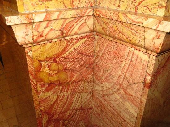
Abstract: The little-known Beulah Marble Quarry, located in western Pueblo County in southern Colorado, was the source for the ornate ornamental stone wainscoting prominently displayed throughout the Colorado state capitol building. Three quarries were operated from 1894 through 1900 by the Beulah Marble Company and later the Denver Onyx and Marble company. The marble, also known as Colorado Rose Onyx and Beulah Red, is hosted by the Mississippian Leadville Limestone and consists of elaborately patterned hematitic leisengang-banded limestone. It was formed by multi-stage paleokarst dissolution features localized at the Leadville/Fountain Formation unconformity.
=
Geographies Unrealized, The Story of Four Cartographic Myths of North America
Donald L. McGuirk, Rocky Mountain Map Society
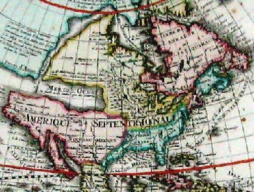
Abstract: Maps, as graphic depictions of geography, simplify and facilitate the dissemination of geographic information. However, occasionally, in the process of expanding geographic knowledge, errors of interpretation lead to misrepresentations of the geography portrayed. At times maps have depicted fancies rather than facts; at other times they have shown wishes rather than wisdom, based on alleged facts. This presentation will discuss four such fanciful geographies depicted on North America from 1525 to 1780. These include: the Sea of Verrazano, California as an Island, Mer de L’Ouest (the Western Sea of the French), and The Extension of North America’s West coast.
=
March
A Cook’s Tour of Colorado’s Glacial Landscape
Dr. Vince Matthews, Leadville Geology
Thursday, March 21, 2019
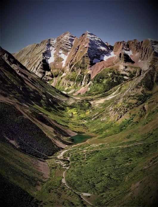
This is probably not the first time you have seen a similar image of these majestic peaks. Hordes of people ride the bus each summer to gaze upon the iconic Maroon Bells. But, how many of them realize that one reason they are so spectacular is because the bells are framed by a U-shaped glacial valley with faceted spurs and hanging valleys along its sides? And— how many of those realize that the valley was once filled with nearly 2,000 feet of ice? And— how many notice the rock glacier pouring out of the hanging valley below North Maroon Peak? And— how many of those realize that the rock glacier is flowing at 2.2 feet per year?
Throughout most of Earth history, glaciers did not exist on Earth. We are fortunate because we live in a time when glaciers reside on nearly every continent, even though we are in a warmer interglacial stade. Why is this a big deal?

Note: Small glaciers in alpine cirques are not shown. The mountains would have been mainly snow covered, with the tops and ridges peaking out.
Without glaciers to observe elsewhere on Earth, we might not be able to figure out what caused some of our most interesting landforms in Colorado. Suppose alpine glaciers did not exist on Earth today. Would we then be smart enough to propose that some valleys in Colorado had once been filled with ice thicker than the One World Trade Center is tall (1,776′)?
Dr. Vincent Matthews III has had a long and varied career in geology, in industry and academia. He was the Colorado State Geologist and Director of the Colorado Geological Survey from 2004-2012. Vince was the author of Messages in Stone, Colorado’s Colorful Geology (two editions, 2003 and 2009). Though he now resides in Wisconsin, Vince is on the Board of Directors of the National Mining Hall of Fame and Museum, Leadville, CO; he writes a periodic blog via Facebook on “Leadville Geology”, and he is working on a forthcoming book, Land of Ice: A Guide to Colorado’s Glacial Landscape.
=
April
Colorado Scientific Society Past Presidents’ Dinner
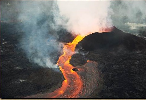
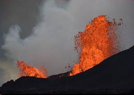
Kilauea’s 2018 Eruption – New methods and perspectives for monitoring volcanic eruptions
Don Becker, USGS videographer, and Jeff Sloan, USGS UAS (Unmanned Aircraft Systems)
Thursday, April 18, 2019
USGS Unmanned Aircraft Systems (UAS) Response Supporting the Kilauea Volcano Activity
In May 2018, the USGS deployed equipment and trained personnel to provide UAS remote sensing data acquisition over the impacted area of the Mount Kilauea eruption in Hawaii. The UAS response team flew over 1,300 flights totaling more than 300 hours of aerial geospatial and gas emission data collection utilizing nearly 40 different UAS operators from across the nation for a period of four months A USGS volcanologist guided mission planning in coordination with the UAS operations team lead to ensure tight integration of the team’s efforts and the needs of the USGS Hawaiian Volcano Observatory (HVO), the National Park Service, Federal Emergency Management Agency (FEMA) and local emergency managers. The initial missions included providing visible and thermal imagery to monitor lava flows moving through residential areas and threatening critical infrastructure and to construct up-to-date digital elevation models of areas where lava flows had dramatically changed the topography. Measuring concentrations of hazardous gases were also a critical concern to emergency managers so the UAS payload was modified to collect gas data utilizing three different sensors. The Team was routinely asked to provide 24×7 surveillance including separate UAS operations (requiring three shifts) to cover FEMA and HVO data requests to provide situational awareness missions for emergency managers to assess spillovers and new lava channel breakouts.
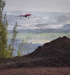
Jeff Sloan works in the USGS UAS (Unmanned Aircraft Systems; i.e., drones) program and showed how they were used at Kilauea. Several different drones were on display at the meeting.
Don Becker’s Presentation about Kilauea’s 2018 Eruption
Don Becker, USGS, is a video producer with the Office of Communications and Publishing and is the manager of the USGS Video Archive and who has made films for the USGS for 43 years. Don has filmed in nearly every U.S. state, Canada, and Africa. He was sent to Hawaii by the Hawaiian Volcano Observatory for a two-week period to film and document the USGS scientists working the 2018 Kīlauea eruption and earthquake-damaged HVO building near the Halema`uma`u crater. Don has in the archive nearly all the USGS footage of the 2018 Kīlauea eruption, which lasted from around the end of April to early September 2018. Don will show footage acquired from the on-scene HVO scientists along with what he filmed, including spectacular, rare footage of an earthquake at the Jaggar Museum at the summit, and will present a brief history of the eruption using footage from the ground, helicopter, and UAS.
Don had the experience of a lifetime seeing an actual volcano eruption in progress, something that he had hoped to do since childhood. His first view of the erupting Fissure 8 in the Lower East Rift Zone (LERZ) was on an early morning helicopter overflight. He filmed the eruption from several angles from the air, then proceeded to film down the length of the 6-mile lava flow to the ocean entry. After landing on a remote road so he could get out of the helicopter to make room for animal rescue folks who quickly needed to use the helicopter to remove dogs from a house being overrun by the lava flow, he resumed the flight back to the forward operating base. He then went out with a ground crew to Leilani Estates and filmed the crew, fissure 8, and the lava flow from the ground. He did this same routine for several days, and then also spent several days at the summit filming the Halemaumau crater. While at the summit, he rode through several magnitude 5.4 earthquakes that were caused by rockfalls in the crater left empty by the drainage of the lava into the LERZ. Don then spent time filming with the UAS crew who were using their aircraft to document the physical changes to the Halema`uma`u crater and they were simultaneously recording level readings with a gas sensor on the aircraft. He got wonderful footage of the crew doing their setup and flights. During his time on Hawaii, Don got to experience filming the lava flow at night, which was an amazing sight. Don filmed a one-on-one interview at the summit Volcano House with Don Swanson, USGS, a Research Geologist at HVO, formerly of the Cascades Volcano Observatory where he worked intimately with the eruption of Mount St. Helens. The interview was interrupted on multiple occasions due to large earthquakes. Lastly, Don was asked to film the inside and outside of the HVO building, damaged during the many earthquakes. At that time, the earthquakes were on an approximate 24-hour schedule, so when he was done at the HVO, he set up a camera just outside the Jaggar museum, on a tripod with the legs stretched far out so it could not tip over. As you will see, the resulting footage was spectacular; the next earthquake caused the sidewalk to open up and the rock wall begin to crumble. Don’s hope is that you enjoy seeing the fierce beauty in the volcano eruption that caused so many local homeowners to lose everything that they owned and their lives to be changed forever.
=
May
Colorado Scientific Society Emmons Lecture
Synthesis, serendipity, and an open mind: timely approaches to timeless challenges in mineral deposits
Dr. Mark Barton, Univ. of Arizona, Lowell Institute for Mineral Resources
Tuesday, May 14, 2019
Abstract: Fe-oxide(-Cu-Au) [aka “IOCG”], Carlin-type Au, and other ore system enigmas are intriguing because of the challenges they pose. Surface fluids likely play a larger (and readily testable) role than is widely accepted. Why then are there dramatic differences in interpretation? Too often comfortable answers—geological stories—seem sufficient. Partly too because we have become tool-focused. The last decade, indeed the last century, has seen remarkable advances in the many tools applied to mineral deposits, even though the basic questions and the fundamental applications have largely remained the same. With the newest results it is easy to be facile; yet while state-of-the-art tools are important they are subordinate to critical thinking and, in particular, to being open to and willing to test alternative ideas – Chamberlin’s “multiple working hypotheses” – or to confronting the discomfort of Peirce’s “irritation of doubt.” Luck too plays a central role, but it’s a role that speaks best to an open, prepared mind. In this talk, I share how my understanding of these and other fascinating mineral systems continues to evolve in response to new ideas and observations, and to the immense value of past work.
Mark Barton is Professor of Geosciences and and Co-Director of the Lowell Institute for Mineral Resources at the University of Arizona. Mark earned BS and MS degrees from Virginia Tech (1977, 1978) and a PhD from the University of Chicago (1981). Following a post-doctoral fellowship at the Geophysical Laboratory (Carnegie Institution of Washington), he taught at the University of California, Los Angeles (UCLA) before joining the faculty at the University of Arizona. His research interests and span many aspects of energy and mass transfer in the Earth’s lithosphere and their applications to mineral deposits. He co-founded the Lowell Institute for Mineral Resources which is a state-, industry-, and privately-funded interdisciplinary organization that catalyzes and facilitates research and education related to mineral resources spanning science and engineering to public health and policy. In the early 2000s, he collaborated with his former PhD students David Johnson and Eric Jensen in founding Bronco Creek Exploration which is now part of EMX Royalty.
=
September
Poster and Oral Presentation Night
Thursday, September 19, 2019
The Colorado Scientific Society hosted an evening of short oral talks and geology/earth science poster presentations.
5:30 pm – Social time, complimentary refreshments – some from Golden City Brewery, and poster viewing
7:15 pm – Oral presentations (4 x 15-minute talks)
Posters
-
- Reanalysis of the Eisenhower-Johnson Memorial Tunnels design and construction case study
Gauen Rhys Alexander (Colorado School of Mines), Marte Gutierrez, Ashton Krajnovich, Stephen Harelson
- Reanalysis of the Eisenhower-Johnson Memorial Tunnels design and construction case study
-
- Holocene climate of the western Kenai lowlands, Alaska, based on pore water stable isotopes and plant macrofossil assemblages of peatland permafrost
Lesleigh Anderson (USGS), Miriam Jones, Ben Jones, Virginia Littell
- Holocene climate of the western Kenai lowlands, Alaska, based on pore water stable isotopes and plant macrofossil assemblages of peatland permafrost
-
- Seismicity of the Earth 1900-2018
Harley Benz (USGS), Gavin Hayes, Gregory Smoczyk, Antonio Villasenor, Kevin Furlong.
- Seismicity of the Earth 1900-2018
-
- Autumn soil moisture reconstruction from tree rings in the Upper Colorado River basin, U.S.A.
Becky Brice (University of Arizona) and Connie Woodhouse
- Autumn soil moisture reconstruction from tree rings in the Upper Colorado River basin, U.S.A.
-
- A new way to map surface inundation using ground-reflected GPS signals
Clara Chew (UCAR)
- A new way to map surface inundation using ground-reflected GPS signals
-
- Linking lithology, structure, and rock properties to observed seismic anisotropy in Colorado Rocky Mountain Crust
Michael Frothingham (University of Colorado), Kevin Mahan, Vera Schulte-Pelkum, Jonathan Saul Caine
- Linking lithology, structure, and rock properties to observed seismic anisotropy in Colorado Rocky Mountain Crust
-
- Paleoflood Hydrology of the Deadwood River, Idaho
Giorgia Fulcheri (USBR), Jeanne Godaire, Caroline Ubing, Amanda Stone, Jennifer Bountry.
- Paleoflood Hydrology of the Deadwood River, Idaho
-
- Understanding future changes in tropical cyclogenesis using Self-Organizing Maps
Abigail B Jaye (NCAR), Cindy L Bruyere, James M Done.
- Understanding future changes in tropical cyclogenesis using Self-Organizing Maps
-
- Can water-rich melts in Earth’s upper mantle be seismically detected? A shackles-compression study on Thor
Lindsay Harrison (University of Colorado), Alisha N. Clark, Steven D. Jacobsen, Adam R. Sarafian, Jean-Paul Davis, Brian S. Stoltzfus, J. Matthew Lane, Kyle R. Cochrane, Joshua P. Townsend, and Christopher T. Seagle
- Can water-rich melts in Earth’s upper mantle be seismically detected? A shackles-compression study on Thor
-
- Process-based evolution models of steep river channels by migration of bedrock steps
Aaron Hurst (University of Colorado and INSTAAR), Robert S. Anderson, John Crimaldi
- Process-based evolution models of steep river channels by migration of bedrock steps
-
- The improvement of sludge settling through hydraulic selection
Rudy A. Maltos (Colorado School of Mines), Ryan W. Holloway, Tzahi Y. Cath
- The improvement of sludge settling through hydraulic selection
-
- Planning for water supply and demand imbalances using a hybrid weather generator with stakeholder-informed hydroclimate metricsKristin Mikkelson (USBR), Lindsay Bearup, Subhrendu Gangopadhyay
-
- Rapid geophysical profiling and satellite remote sensing data fusion for canal and levee health assessment
Justin Rittgers (USBR).
- Rapid geophysical profiling and satellite remote sensing data fusion for canal and levee health assessment
-
- In-situ chemical analysis of hydrocarbons at a nanopore scale, Cretaceous Niobrara Formation, Denver Basin, Colorado
Rebekah Simon (University of Colorado), Omar Khatib, Markus B. Raschke, and David A. Budd
- In-situ chemical analysis of hydrocarbons at a nanopore scale, Cretaceous Niobrara Formation, Denver Basin, Colorado
-
- Regional-scale three-dimensional geologic maps of the Intermountain West—a potential starting point to a national-scale geologic model
Don Sweetkind (USGS)
- Regional-scale three-dimensional geologic maps of the Intermountain West—a potential starting point to a national-scale geologic model
-
- The economic risk of drought on Colorado’s commercial rafting industry
Adam N. Wlostowski (Lynker Technologies), Page Weil, Megan O’Grady, Ryan Spies, and Graeme Aggett
- The economic risk of drought on Colorado’s commercial rafting industry
-
- Abundant late-stage andraditic garnet in actively serpentinizing mantle rocks in Oman and its implications for microbial habitability
Spencer KD Zeigler (University of Colorado), Eric T Ellison, Lisa E Mayhew, Alexis S Templeton, and The Oman Drilling Project Phase II Scientific Team.
- Abundant late-stage andraditic garnet in actively serpentinizing mantle rocks in Oman and its implications for microbial habitability
- Sedimentological evidence for increased precipitation extremes at the Paleocene-Eocene boundary in the San Juan Basin of New Mexico
Kristine L. Zellman (USGS), Piret Plink-Bjorklund, Henry C. Fricke
Lectures
-
- U-Pb laser ablation inductively coupled mass spectrometry (U-Pb LA-ICP-MS) zircon age constraints on the tectonic origin of the Avalon terrane in southeastern New England
Sonia Ellison (Colorado School of Mines), Yvette Kuiper, J. Crowley, D. Murray
- U-Pb laser ablation inductively coupled mass spectrometry (U-Pb LA-ICP-MS) zircon age constraints on the tectonic origin of the Avalon terrane in southeastern New England
-
- Monitoring the terrestrial water cycle with GPS vertical displacements
Thomas Enzminger (University of Colorado), Eric Small, Adrian Borsa
- Monitoring the terrestrial water cycle with GPS vertical displacements
-
- Use of statistical process control for fault detection in decentralized wastewater treatment
Kate Newhart (Colorado School of Mines), Klanderman, M., Hering, A.S., Cath, T.Y.
- Use of statistical process control for fault detection in decentralized wastewater treatment
- Putting stress to the test: assessing variation in stress among and within American pika territories
Ashley Whipple (University of Colorado and INSTAAR), Chris Ray
=
October
Thursday, October 17, 2019
Brooklyn Mine Geophysical Investigations, Bonita Peak Mining District, Silverton, Colorado
Bethany Burton, a geophysicist with the USGS Geology, Geophysics, and Geochemistry Science Center in Denver, Colorado.
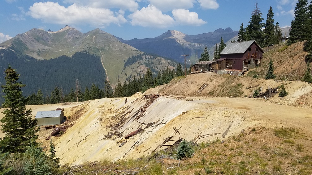
Abstract: The Bonita Peak Mining District was added to the Superfund National Priority List in September 2016 and includes 48 sites where mining-related contamination exists in the drainages of Mineral Creek, Cement Creek, and Upper Animas River in San Juan County, Colorado. The regional mineralization and ore emplacement are associated with the San Juan and Silverton caldera complex in the western San Juan Mountains. A once active gold mining district for decades, the presence of these mines and associated waste rock and tailings piles contribute to high heavy metal loads and acidity in surface and groundwater in the region.
The U.S. Geological Survey (USGS) and U.S. Army Corps of Engineers (USACE) collaborated on a pilot study at Brooklyn Mine, situated on U.S. Forest Service (USFS) land, to demonstrate the utility of selected ground-based geophysical methods to aid in characterizing abandoned mine lands (AML). This information will be used to inform remediation design strategies by USFS and to help prioritize strategies for other AML. Specific priorities for geophysical characterization at this site include: (1) identification of shallow groundwater seepage from settling ponds and through waste rock piles, (2) mapping of mine adits from the surface and determination of whether they are air- or water-filled, and (3) determination of the volume of waste rock that has accumulated and been reworked over time outside of the adit entrances. Preliminary results of the geophysical studies as well as an overview of the newly acquired airborne electromagnetic and magnetic survey acquired over the entire mining district will be discussed.
Bethany Burton is a geophysicist with the USGS Geology, Geophysics, and Geochemistry Science Center in Denver, Colorado. Since joining the USGS in 2002, she has been involved in applying geophysics to infrastructure, mineral and water resources, and environmental remediation studies both domestically and internationally as well as leading the potential field acquisition for several climate change-related airborne projects in Greenland and Antarctica. She is a past President of the Environmental and Engineering Geophysical Society and currently serves on the Geoscientists Without Borders technical committee. Beth received a B.S. in Geophysical Engineering and M.Sc. in Geophysics from the Colorado School of Mines.
=
Geology: It’s not just for scenery anymore…
The National Park Service Geologic Resources Inventory
Tim Connors, National Park Service Geologic Resources Division, Lakewood, Colorado
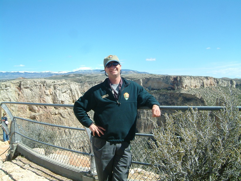
Abstract: Many units of the National Park Service were set aside because of their unique geologic features and processes. Examples that come readily to mind are Yellowstone, Arches, Grand Canyon, Badlands, Mammoth Cave, and Mount Rainier. However, often a park’s basic “geology” is overlooked as a significant natural resource and regarded as merely static features responsible only for the scenery. Aficionados of geology in the National Park Service and the Geologic Resources Division are making strides to change this perception and to promote the concept that geology is indeed, the “bedrock of the ecosystem”. This talk will outline our inventory efforts since 1998 with products (digital geologic GIS maps, report PDFs, and list of park specific features, issues and processes) and overall status of progress for achieving this for some 270 NPS areas.
See the National Park Service, Geologic Resource Inventory for details about the geological resources in our National Parks. The images are linked into short courses on everything from glacial geology to igneous rocks. There are also free, downloadable geologic maps for most parks.
Tim Connors is a geologist for the National Park Service Geologic Resources Division in Lakewood, Colorado since 1997. He joined the NPS after completing a B.S in Geology in 1991 and M.S in Geology in 1996, both from the University of Toledo (Ohio). He has also been a lecturer and teach undergraduate geology courses at the University of Colorado Denver since 2008 (Physical Geology and Geology of Colorado); a member of the Board of Directors for the Friends of Dinosaur Ridge (Morrison, Colorado; 1999-2014).
His work takes him to NPS areas in Alaska, Hawaii / Pacific Islands, Virgin Islands, and the lower 48 states, allowing him to become familiar with numerous geologic terranes, processes and features of our wonderful planet and how they are often showcased in our National Park areas.
He also works to develop digital GIS-based maps of our parks as well as developing databases to relay important information on geologic features, issues and processes that feed park planning strategies.
=
November
Archaeology of Peru’s North Coast: The Moche Culture and Beyond
Michele Koons, Curator of Archaeology, Denver Museum of Nature and Science
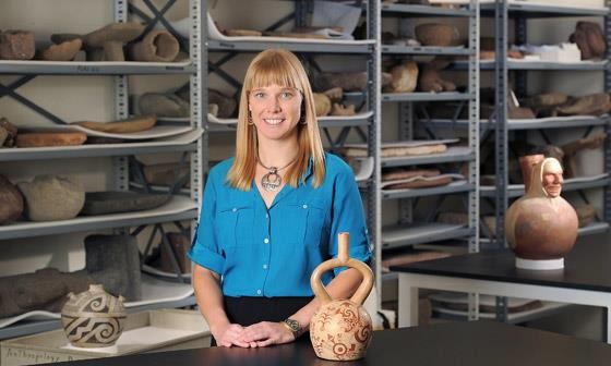
Abstract: This presentation will explore the politics and power of the Moche archaeological culture (250-900 AD) of the North Coast of Peru. Moche’s distinct archaeological signatures (exquisitely decorated ceramics, monumental architecture, polychrome murals, metalwork, etc.) have long been seen as the first evidence for a South American state. However, current scholars have begun to pull apart these assumptions and view Moche as a more complex mosaic of interacting settlements across a landscape. I will explore the evidence that supports this current trend in thinking, while focusing specifically on recent work at the site of Pañamarca—one of the southern-most Moche settlements known for its elaborate multi-colored murals.
Dr. Michele Koons is the Curator of Archaeology at the Denver Museum of Nature & Science (DMNS). Dr. Koons studies ancient socio-political dynamics, cultural landscapes, and how people of the past interacted with their environment. Currently, she directs three field programs. The first is a community-based public archaeology project at the hunter-gatherer site Magic Mountain in Golden, CO. Her second project is excavating a great kiva in the Gila National Forest of New Mexico and exploring the cultural landscape of the kiva’s surroundings. Finally, Michele is co-PI on a project examining the human impact on the environment through time of the Nepeña Valley in northern coastal Peru.
=
December
2019 CSS President’s Address
Geoheritage – a new frontier for the Earth Sciences
Thursday, December 19, 2019
Tom Casadevall, Scientist Emeritus, US Geological Survey
Abstract: The cumulative evidence of Earth’s long and dynamic history is embodied in unique and beautiful destinations across the United States and around the globe. Collectively, this record comprises our geoheritage — a legacy of landscapes, landforms, and features with significant scientific, cultural, educational, or historical value that embodies the connection between people, the land, and the processes that have formed, and continue to shape, our singular planet. Geoconservation is the action taken with the intent of conserving and enhancing our geoheritage – the geological and geomorphological features, processes, sites and specimens that make up our landscape.
To help inform and educate Americans about geoheritage and promote the conservation of geologically important sites, the National Academy of Sciences established the U.S. Geoheritage and Geoparks Advisory Group in 2016 as a program development activity of the U.S. National Committee for the International Union of Geological Sciences. The advisory group’s principal aim is to promote an understanding and recognition of geoheritage within the United States.
To accomplish this goal, the Advisory Group is working with willing partners, including the Association of American State Geologists (AASG), the Geological Society of America (GSA), the American Geosciences Institute (AGI), and the National Park Service (NPS), among others so that interested communities, states, and land-management organizations can develop and tailor a program that highlights the geological diversity found within their borders.
In the arc of development of the Earth Sciences, geoheritage conservation represents a relatively new frontier requiring fresh ways of looking at and thinking about the diversity of our landscapes and Earth history.

Tom’s bio: Thomas Casadevall is a Scientist Emeritus with the U.S. Geological Survey in Denver since 2008. His scientific interests focus on mineral resources related to volcanic environments; on active volcanism and the related hazards to people and aviation operations; and on geologic heritage with an emphasis on Protected Volcanic Landscapes. He currently leads the U.S. Geoheritage and Geoparks Advisory Group and has undertaken the revision of the International Union for the Conservation of Nature (IUCN) thematic study on World Heritage Volcanoes.
From 1996 through 2008, Tom served in the Office of the Director, USGS, with terms are Regional Director for the Western Region (1996-1997), Acting Director of the USGS (1998), Deputy Director (1999-2000) and Regional Director for the Central Region (2000-2008). From 1978 to 1996, he worked as a geologist with the USGS Volcano Hazards Program, stationed at the Hawaiian Volcano Observatory, the Cascades Volcano Observatory, the Alaskan Volcano Observatory, and Denver. From 1989 to 1996, he led the USGS project Volcanic Hazards and Aviation Safety. From 1985 to 1998, he was Advisory Volcanologist to the Volcanological Survey of Indonesia, residing in Java, Indonesia. From 1997 to 1998, he taught geology of volcanic environments at the Escuela Politecnica Nacional in Quito, Ecuador. From 1969 to 1972, he worked as a mineral exploration geologist with Bear Creek Mining Company, and from 1972 to 1974 he worked as production geologist for the Sunnyside Gold Mine at Silverton, Colorado.
Tom holds an M.A. in Geology and a Ph.D. in Geochemistry from the Pennsylvania State University. He holds a B.A. in Anthropology and Geology from Beloit College.