Colorado Scientific Society Field Trips – 2000-2009
The Colorado Scientific Society usually has a Spring and a Fall field trip, with field trip guides, maps and other illustrations, and pictures of people learning and enjoying themselves. The most recent field trips are listed first.
The field trip guides for some field trip’s can be downloaded, usually as PDFs. The size of files larger than 3 MB is called out in the link, e.g. “Quaternary San Luis Basin, Ancient Lake Alamosa, 2007 (PDF 4.6 MB)”.
Field trips are presented with the most recent first. Some field trips with many pictures and maps have their own pages.
=
2009
Front Range Tertiary and Quaternary Geology – Honoring Glenn Scott, Fall 2009
The trip featured the geology of the western Colorado Piedmont and adjoining Front Range, and focused in particular on Quaternary geology and geomorphology, Tertiary erosion surfaces, and zonation of the Pierre Shale, topics to which Glenn has made major contributions.
See details in the flyer: 2009 Front Range Field Trip to Honor Glen Scott
=
Victor Gold Mine Tour and Front Range Geology
Saturday, May 16, 2009
Leader: Tim Brown, Victor Mine
The Victor Mine open pit gold mine exposes the innards of the ancient volcano outside of Cripple
Creek, Colorado. Strange rocks and volcanic structures of many types will be seen—phonolites, lamprophyres,
and volcanic cooling columns. Tunnels of the old mine workings in the high wall show how the richest gold deposit in Colorado was worked over a century ago. We will also visit the crusher building and see how gold is extracted from the huge leach heaps.
Tour of the Victor Gold Mine, field trip announcement
=
2008
Northern Never Summer Range volcanic field – The search for Braddock’s Caldera
September 6-7, 2008
Leaders: Ed Larson, CU Geology, Jim Cole, USGS, Karl Kellogg, USGS, Lang Farmer, CU Geology
This field trip focused primarily on the post-Laramide history of the northern Front Range involving the Late Oligocene magmatic activity in the Never Summer Mountains (about 30 to 27 Ma), coeval and younger faulting, and the evolution of drainage systems since then. We will also examine late Laramide (middle Eocene?) thrust faulting just west of Cameron Pass and complications arising from younger high-angle faults and possible wrench faults.
Most of the geology of this area was mapped by Prof. Bill Braddock (University of Colorado, Boulder) and graduate students under his direction in the 1970’s and 1980’s.
2008-Sept Northern Never Summer Volcanic Field – The Search for Braddock’s Caldera (8.4 MB), CSS field trip guide
Amazonite-bearing pegmatites in the Pikes Peak Batholith, near Harris Park, Park County, CO
New Insights into the Geologic and Geomorphic Evolution of South Park Basin
2007
Florissant Fossil Beds National Monument
Saturday, October 6, 2007
Herb Meyer, resident paleontologist at FFBNM, and past CSS President Emmett Evanoff, who has worked extensively in the fossil beds, led this trip. The following quote from the Monument website eloquently describes the essence of Florissant: “Beneath a grassy mountain valley in central Colorado lies one of the richest and most diverse fossil deposits in the world. Petrified redwood stumps up to 14 feet wide and thousands of detailed fossils of insects and plants reveal the story of a very different, prehistoric Colorado.” We had the opportunity to hunt for fossil insects and plants in a private quarry adjacent to the monument.
Mining History of Colorful Central City
Saturday, September 29, 2007
Leader: Beth Simmons, CSS history chair and Gilpin County Historical Society
Join us for an exploration of Central City’s rich mining history. Although we won’t entirely ignore the geology of the Idaho Springs-Central City district, a world-class Au-Ag-Cu-Pb-Zn-U deposit, the focus of this trip is on the history of mining and many of the colorful people involved. It is thus intended for people of all geologic and non-geologic backgrounds. As we drive up beautiful Golden Gate Canyon, we’ll look briefly at the history of settlement and mining from Golden to Central City. We plan to visit the famous Glory Hole, within the much-hyped “richest square mile on earth,” and we’ll go underground at the historic, recently restored Hidee Mine and actually mine a little gold-bearing pyrite ore. We’ll also visit the fascinating Gilpin County History Museum in Central City that houses the oldest ore collection in the state. The trip leader was Beth Simmons, CSS history chairperson and active with both Friends of Dinosaur Ridge and the Gilpin County Historical Society, although others will be offering various insights as well.
=
Quaternary Geology of the San Luis Basin near Alamosa, Colorado with Ancient Lake Alamosa
June 2-3, 2007
Led by Michael Machette, U.S. Geological Survey
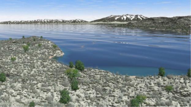
View is to the NNE from San Luis Hills.
The CSS spring field trip was led by Mike Machette to ancient Lake Alamosa, the Plio-Pleistocene lake that occupied a large part of the San Luis Valley. On this trip, participants examined various lake features, such as spits, bars and lagoon deposits, discussed the timing and ultimate overflow of the lake, peat and tufa deposits, and visited the Quaternary Mesita Volcano. The trip also visited the Sangre de Cristo fault zone and its scarps near Fort Garland, some of which are as young as early Holocene. There was a brief stop near Kenosha Pass to arm wave at the eastern margin of South Park where mapping by USGS has shown possible late Quaternary faults.
Download the field trip guide for the Quaternary San Luis Basin and Ancient Lake Alamosa (PDF):
Quaternary San Luis Basin, Ancient Lake Alamosa, 2007 (PDF 4.6 MB)
=
2006
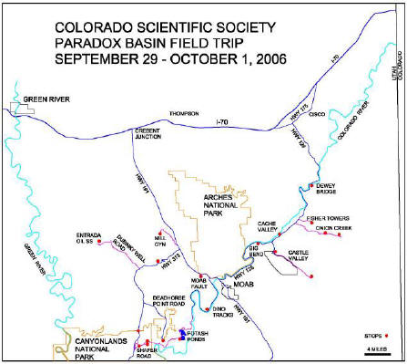
CSS Fall Field Trip to the Paradox Basin
The 2006 Fall Field Trip for the Colorado Scientific Society was to the Paradox Basin, on September 29- October 1, 2006. The trip leader was Don Rasmussen, who has worked in the Basin for more than 30 years and has led numerous field excursions for universities and industry into the region. The trip began and ended in the La Quinta Hotel parking lot in Moab, Utah.
=
2005
Gunnison Area
Trip Leaders: Bruce Bartleson and Alan Stork. Western State College; and Pete Modreski, USGS
The 2005 CSS fall field trip was to the Gunnison/Crested Butte area in central Colorado. The first day included traveling to Gunnison, then a half-day tour of the Powderhorn carbonatite. The second day’s topic was the structure of the Ancestral and Laramide Rockies as seen in the Elk Mountains near Crested Butte. Stops for the second day included discussions of the structures around Almont and Jack’s Cabin, Crested Butte/Gothic, and Schofield Park. We went on a hike up to Schofield Basin and the Hasley Pass area to see an excellent view of the Elk Range thrust fault. The third day’s topic was the Tertiary volcanism and igneous activity in the Gunnison Basin. Stops will include the Ohio Creek valley to see the West Elk laccolith cluster and a series of 10 Ma basalt flows on Red Mountain. We will also see the ash-flow tuffs from the San Juans near Blue Mesa Reservoir and a drive up Red Creek to a great view of the 30 Ma West Elk Volcano. The fourth day included the travel back to Denver with stops along the route.
Western State College hosted the 2006 Rocky Mountain Section Meeting of the GSA. The CSS fall field trip was be a preview of some of the field trips associated with this meeting.
=
South Platte country – White Cloud Pegmatites, Buffalo Creek Fire, and Flood
Led by Pete Modreski
June 11, 2005
A field trip to visit (1) the White Cloud Pegmatite, part of the South Platte Pegmatite District within the Pikes Peak Batholith, and (2) to see erosion, sedimentation, and ecological recovery in the aftermath of the June 1996 Buffalo Creek forest fire and flash flood. The trip will involve a 2-3 mile (round trip) hike beginning at the Colorado Trail footbridge just south of the confluence of the North and South Forks of the South Platte River. The hike will take us partly on the Colorado Trail, off-trail down a steep 400′ hillside, and downstream along the wide gravel bed of Spring Creek.
Field guide here: Buffalo Creek Field Trip_June 11, 2005
=
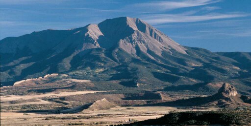
Spanish Peaks
Led by Dr. Brian Penn
May 14, 2005
=
Volcanic and Plutonic rocks of Table Mountain
Led by Harald Drewes
April 23, 2005
North Table Mountain field trip guide, April 2005
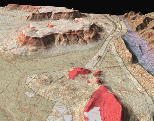
Southward view showing the Ralston “dikes” and North and South Table Mountains.
The lava flows capping the Table Mountains are thought to have originated from Ralston dikes.
Pictures from the CSS 2005 North Table Mtn field trip
=
2004
Black Hills and Badlands, South Dakota
September 23-26, 2004
Black Hills Leaders: John Lufkin, Jack Redden, and Alvis Lisenbee
Badlands Leader: Emmett Evanoff
The guidebook for the Black Hills portion has not been scanned and uploaded yet.
Download the guidebook for the 2004-Sept, Badlands National Park (2 MB) field trip.
=
Proterozoic Accretionary Terrane of the Central Colorado Front Range
August 14, 2004
Leaders: Lisa Fisher and Thomas Fisher, Colorado School of Mines
Download the field trip guidebook: 2004-Aug, Proterozoic Accretionary Terrane of the Central Colorado Front Range (4.1 MB)
=
The Colorado Front Range, Anatomy of a Laramide Uplift
May 30, 2004
Leaders: Karl Kellogg, Bruce Bryant, and John C. Reed, Jr, USGS
2004-May, Colorado Front Range-Anatomy of a Laramide Uplift (3.1 MB)
=
The Tectonics and Precambrian Geology of the Front Range between Golden and Marshall
Sunday, April 4, 2004
Leaders: Robert J. Weimer and Lisa A. Lytle, with Colorado School of Mines
The Colorado Scientific Society presented this field trip in conjunction with the Symposium of the Geology of the Front Range. The field trip examined the tectonic features along the margin and some of the Precambrian features of within the Front Range between Golden and Marshall.
2004-April, Laramide and Precambrian Geology and Tectonics of the Central Front Range (4 MB) with Emphasis on Laramide Tectonics and Precambrian Accretion of Colorado – field trip guidebook
=
2003
Upper Cretaceous, lower Paleocene, and early Eocene rocks of the Denver Basin
The first 2003 Colorado Scientific Society brown-bag field trip was held on Saturday, June 21. The trip examined the Upper Cretaceous, lower Paleocene, and early Eocene rocks of the Denver Basin; it was led by Bob Raynolds of the Denver Museum of Nature and Science. Bob vividly linked the stratigraphy, tectonics, and groundwater resources of these rocks into a comprehensive story of the Laramide development of the Denver Basin and the Front Range. Highlights of the trip included a grand overview at Daniels Park, a climb to another spectacular overlook on Wildcat Mountain, a walk into the depths of Castlewood Canyon, and finally a view of the lower Eocene paleosol near Parker. The trip’s 19 participants enjoyed the first non-rainy Saturday in June.
=
Northern San Juan Volcanic Field
September 20-21, 2003
Leader: Peter Lipman
This portion of the Fall field trip focused on “ignimbrite sheets and calderas in the little studied northeastern flank of the well known Oligocene San Juan volcanic field.” We explored the Cochetopa Park caldera, and viewed “the northern segment (Saguache Park) of the giant La Garita caldera”, “the source of the >5,000 km3 Fish Canyon Tuff (27.6 Ma).” On the second day we followed Los Pinos road past exposures of multiple tuffs and over Los Pinos Pass. Lunch was at the Cathedral Creek Ranch off of Cebolla Creek, below cliffs of Rat Creek Tuff and Nelson Mountain Tuff “banked depositionally against the Cebolla Creek caldera wall.” On the way to Lake City and its caldera, we viewed the wall of the Uncompahgre caldera. Going back to Gunnison were more intracaldera and outflow tuffs and a precaldera volcano and dikes. You can follow our route with Peter Lipman’s guide.
2003-Sept, Northern San Juan Volcanic Field (5 MB) field trip guide
=
Field trip to the Pawnee Buttes
Spring 2003
Leader: Emmett Evanoff
2003 Spring field trip to Pawnee Buttes (2.2 MB)
And: Rocks and Faunas, Ogallala Group, Pawnee Buttes Area, Weld County, CO (2 MB) by Richard H. Tedford.
=
Fall 2002
Jackson Hole, Wyoming and the Tetons
Hayden survey sketch of Teton Valley from Upper Gros Ventre Butte.
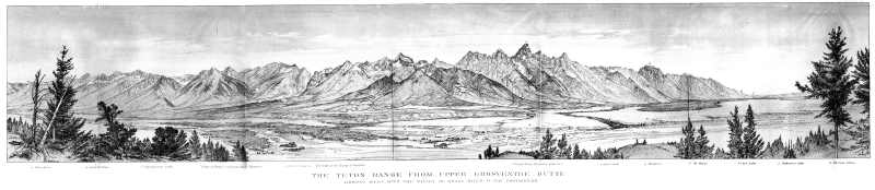
The Teton Range from Upper Gros Ventre Butte
The Fall 2002 Field Trip for the Colorado Scientific Society will visit Jackson Hole, Wyoming. Not only is Jackson Hole and the Teton Range one of the most spectacular landscapes in the United States, but this trip will be at a time when the fall colors should still be in all of their glory. The field trip leaders will be Ken Pierce, Jack Reed, and Lisa Morgan, all of the U.S.G.S. Ken (past president of the CSS) has worked out a detailed glacial history of the valley. Jack Reed (another past president) has studied the Precambrian rocks of the Teton Range, and is currently working with J. D. Love on the second edition to the geologic guide, the Creation of the Teton Landscape. Lisa Morgan has been investigating the Tertiary geology of Jackson Hole, and has determined the timing of the rise of the Teton Range. All three leaders are now experienced field trip guides, and will provide an excellent learning experience. The trip will be from Friday, 20 September to Monday, 23 September.