Colorado Scientific Society Field Trips, 2019-2010
The Colorado Scientific Society usually has a Spring and a Fall field trip, with field trip guides, maps and other illustrations, and pictures of people learning and enjoying themselves. The most recent field trips are listed first.
The field trip guides for some field trip’s can be downloaded, usually as PDFs. The size of files larger than 3 MB is called out in the link, e.g. “Quaternary San Luis Basin, Ancient Lake Alamosa, 2007 (PDF 4.6 MB)”.
Field trips are presented with the most recent first. Some field trips with many pictures and maps have their own pages.
2019
Denver Basin Geology, May 2019
CSS 2019 Spring Field Trip, May 19, 2019
Leaders: Mark Mitchell, Jason McGraw, Donna Anderson, and David Lindsey. Organized by Tom Casadevall
This was a one-day field trip with stops relating cultural, mining, and industrial exploration and discovery to the geologic and Pleistocene geomorphic evolution of the western margin of the Denver Basin.
This field trip deserves its own page: Denver Basin Geology, May 2019
2018
Geology of the Upper Arkansas Valley, Sept. 2018
CSS 2018 Fall Field Trip, September 15-16, 2018
Leaders: Karl Kellogg, Cal Ruleman, and Scott Minor, USGS
We spent two days examining diverse geologic features of the beautiful Upper Arkansas Valley:
- Proterozoic sedimentation, volcanism, and plutonism
- Laramide Orogeny structural features
- Northern Rio Grande Rift and Upper Arkansas Valley magmatism, tectonism, and sedimentation
- Pre-rift intrusive rocks and Oligocene and Eocene volcanic rocks
- Glacial history and deposits including catastrophic outwash floods
- Mineral deposits (gold, silver, copper, zinc, lead, fluorspar, and others)
- Landslide, alluvial, mass-movement, eolian, and wetland deposits
This field trip deserves its own page, with all the details: Geology of the Upper Arkansas Valley, September 2018
Front Range Pleistocene Geomorphology and Mysterious Gravel Deposits, April 2018
April 15, 2018
Leaders: Cal Ruleman (USGS), Bob Raynolds (Denver Museum of Nature and Science), and Beth Simmons (retired)
We explored several sites along the I-70 corridor and up along Highway 103 on the northeast shoulder of the Mount Evans massif. We began with an overview of the previous work within the area and relationships that have been previously established, from the Eocene Rocky Mountain erosional surface to Pleistocene incision rates and the timing for onset of major Pleistocene glacial epochs. After our meeting spot overview, our first stop was at the Genessee Park-I-70 junction with discussions pertaining to geomorphology east and west of the Floyd Hill Divide. We then went to the Casino Parkway and the large exposure of the Central City Gravel. Here we had time for personal observation of the deposit and geomorphic relationships. We discussed probable mechanisms for deposition and relationships to distal fan surfaces and chronologic relationships to the east on the Great Plains. We continued up Chicago Creek at Idaho Springs with stops at Last Glacial Maximum (Pinedale) moraines and till deposits for comparison with the Central City Gravel. Proceeding up Highway 103 to Echo Lake and Juniper Pass we observed geomorphic similarities between Bear and Clear Creeks with probable coeval glacial-induced landscape incision. Cal provided a new perspective for future investigations involving Pleistocene geomorphic development of the Rocky Mountain-Great Plains region.
![]()
Looking west above Clear Creek
This field trip deserves its own page, with all the details: Front Range Pleistocene Geomorphology and Mysterious Gravel Deposits
=
2017
CSS Flat Tops/White River Plateau Field Trip
August 26-27, 2017
Emphasizing the Devonian in Colorado and its extinction events, we toured the Paleozoic section exposed on the Flat Tops. Participants also discussed other topics including glacial history and the incision of Colorado River.
Note: Dr. James Hagadorn of the Denver Museum of Nature and Science planned to lead this trip, but coming over from Denver he hit a deer and totaled his car. Fortunately, James was OK. Linda Soar, who has volunteered with DMNS on Flat Tops for years, explained the Devonian and Mississippian sections and fossils near Bison Lake and by the Crane Park quarry.
Saturday, Aug. 25, we drove to Dotsero on I70 and took the Coffee Pot Road up to the Flat Tops. We camped at the White Owl Campground, which is on top of the Flat Tops at 10,680 feet.
Sunday, Aug 26, Look at Devonian section west of Bison Lake and by the Crane Park quarry.
Stop 1: Bison Lake Section – We spent the morning examining the Dyer Formation facies and fossils at Bison Lake, including examination of its contacts with the underlying Parting Sandstone and the overlying Leadville Limestone, and the end-Famennian extinction interval. Ate lunch above Bison Lake.
Stop 2: Crane Park Quarry – Early afternoon – examined the Gooey Lagoon & discuss its origin. We also examined vertebrate teeth-bearing lags, as well as the knobbly-bedded facies of the Dyer exposed at Crane Park Quarry.
Head for home. Some of us headed back Sunday evening. Others avoided the weekend traffic and enjoyed another night at the White Owl Campground.
Follow this link for an interactive Forest Service map that covers the Flat Tops.
Geologic Wonders of the Hart(sel) of South Park, June 2017
June 25, 2017
Leader: Peter Barkmann, Colorado Geological Survey
This field trip explored the Hartsel area, starting with a look at the Precambrian granodiorite and its cross-cutting pegmatite sheets. We then saw the onlap of the Late Paleozoic central Colorado trough sediments onto the ancestral Front Range highland and the Garo Sandstone healing cover. Our transect then looked at the Laramide synorogenic South Park Formation with its complex stratigraphic story. Last but not least was the Neogene transformation from compression to extension with a fascinating story of Neogene tectonic closure of intermontane fluvial systems and progressive integration and incision driven by middle to late Pleistocene glacial episodes.
This field trip deserves its own page, with all the details: Field Trips 2017, Geologic Wonders of the Hartsel of South Park
=
2016
Colorado’s Permian-Triassic: the Lykins Formation
Saturday, August 27, 2016
Leader: Dr. James Hagadorn, Denver Museum of Nature and Science
This field trip will focus on the Permian-Triassic Lykins Formation of eastern Colorado. This unit is of interest because it may contain the Permian-Triassic boundary, and information about what happened locally during this event. Given the nascent nature of our research on the unit, we welcome your interpretations, criticism, and insights about the geology we’ll see on the field trip. This field trip will consist of up to four stops, progressing roughly from the bottom of the Lykins to its top. There will be opportunities to see the units’ contact with the
underlying Lyons Sandstone and the overlying Jelm Formation. There will be a brief detour out of stratigraphic order so that we can see a gypsum quarry that highlights the Blaine Gypsum Member of the Lykins Formation — a member rarely seen in surface outcrops.
Stop 1: Golden Maintenance Facility
This stop will focus on surveying the transition from the Lyons Sandstone to the upper Forelle Member of the Lykins Formation. The first half of this stop provides a cross-sectional view of the lower part of the Lykins Formation, illustrating from bottom to top, the Greenacre Lentil, Falcon Member, and Forelle Member. Stromatolites, solution cavities, and related features are all visible in these units. At the second part of this stop, we will examine and discuss an enigmatic bed top in the upper Forelle Member, which is locally brecciated, contorted, and possibly slumped. How might these bedforms have formed?
Stop 2: Park Creek Reservoir
This stop offers an opportunity to walk the section from the upper Lyons Sandstone through the lower half of the Lykins Formation. Herein we will see the unit’s main carbonate members, including the basal carbonates and the Falcon, Forelle, Poudre, and Park Creek members. We will discuss their contacts, possible karst features, and possible loci of deposition. We will eat lunch at this stop.
Stop 3: Monroe Gypsum Quarry
This private quarry offers a rare opportunity to see a clean exposure of the Blaine Gypsum Member of the Lykins Formation. Here, the gypsum is mined as a cement additive, and more rarely is mined in the region for artist’s alabaster and as an agricultural soil amendment. At this locality, do the evaporites show signs of subaerial exposure or demonstrably marine features?
Stop 4: Optional Stop—Red Mountain Open Space
This offers an opportunity to hike through the ‘color transition’ of the Red Hill Shale Member of the Lykins Formation, and see the contact with the overlying Red Draw Member of the Jelm Formation. At this site, participants may discuss the depositional environments or diagenetic conditions that fostered the color change in the Lykins Formation, the marine versus nonmarine nature of the redbeds, and similarities between the Jelm and Lyons formations.
=
Basement hosted sandstone dikes of the Colorado Front Range
June 25, 2016
Basement hosted sandstone dikes of the Colorado Front Range: structural and other field relations, and contemplation of origins
Leaders: Christine Smith Siddoway, Colorado College, and Scott Lundstrom, USGS
New research in the southern Front Range reveals a Neoproterozoic ancestry for some of the range-bounding faults, due to their association with basement-hosted sandstone dikes that indicate Neoproterozoic age [1], based on detrital zircon (DZ) sedimentary provenance that includes characteristic components from the Grenville Orogen. Informally named Tava sandstone, DZ data indicate that the sandstone dikes and other large associated fault-bounded bodies formed during the Cryogenian Period, and as such the Tava sandstone provides a ‘waypoint’ in the vast span of time between emplacement of the Pikes Peak Granite at ~1.1 Ga and the deposition of Cambrian Sawatch Sandstone upon the Great Unconformity. In other words, it offers access to exploration of paleoenvironments that previously have been inconceivable.
Sandstone injectites are formed by liquefaction, remobilization and intrusion of sand into fractures within host rock, that in most circumstances involves upward injection from buried sands into overlying sediments/sedimentary rocks in active sedimentary basins. Hence the occurrence in Colorado of detrital, nonmetamorphosed injectites within crystalline basement is distinctive, and may require different geological circumstances for downward injection. The sedimentary injectites likely are a product of ’natural fracking’ of the sort that may have been achieved by large magnitude earthquakes, transient subglacial hydraulic conditions of large ice sheets, or regional scale mass wasting (rock slab failure) — possibilities that we hope to explore with CSS members who participate in the field trip.
Exposures of Tava sandstone along the Ute Pass Fault system may be found from Penrose, CO in the south, northwestward to Pine, CO, but this trip will focus on accessible sites near Buffalo Creek, and then proceed to Crystola and Manitou Springs where large associated sandstone bodies can be examined. The road-side stops require no hiking, but the Crystola and Manitou Springs stops (the latter only if there is time) involve hikes upslope, over rough terrain.
[1] Siddoway, C.S. and Gehrels, G.E. (2014) Basement-hosted sandstone dikes of Colorado: a vestige of the Neoproterozoic revealed through detrital zircon provenance analysis: Lithosphere 6(6): 403–408 doi:10.1130/L390.1 (Click to see article)
=
New discoveries of dinosaur tracks and markings at Dinosaur Ridge, Morrison CO
June 18, 2016
Leader: Martin Lockley
Martin showed us “scrape” traces on Dinosaur Ridge. These scrapes are interpreted as evidence of a “nest scrape display”.
2016-June, Dinosaur Courtship, CSS field trip
=
2015
Middle to Late Cenozoic Geology and Geomorphology of the Laramie Mountains, Wyoming
September 12-13, 2015
Leader: Emmett Evanoff, University of Northern Colorado
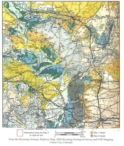
From the field trip announcement: Late Cenozoic incision by rivers removed much of the middle to late Cenozoic deposits in and on the flanks of the Colorado Front Range. Pleistocene glaciers in the Front Range high country greatly modified the Front Range landforms. The Laramie Mountains in southeast Wyoming is a northern extension of the Front Range, but the range was not glaciated and has undergone relatively little stripping of Cenozoic deposits in the mountains and along its flanks. This trip will combine Cenozoic stratigraphy and geomorphology to illustrate the late Cenozoic tectonic history and development of landforms along the Rocky Mountain front. If you are interested in seeing what the Colorado Front Range may have looked like in the Miocene and see late Eocene topography now being exhumed, this is the trip for you.
The trip will stop first along the Gangplank near Cheyenne, Wyoming. We will then travel northwest of Cheyenne to see the relations between the High Plains sequence, the bordering hogbacks, and the Sherman surface near Horse Creek; travel north along Chugwater Creek to see Laramide anticlines now being exhumed under the White River Formation. We will continue north to Wheatland, Wyoming to see post-middle Miocene faults, and topography along the east flank on the Laramie Mountains, and then the rocks and structures of the Hartville Uplift still largely buried by Cenozoic deposits. We will continue north to the largely poorly mapped Neogene faults bounding the northwest flank of the Laramie Mountains, ending in Douglas, Wyoming for the night. The next day will examine the stratigraphic and geomorphic features of the northern Laramie Mountains, including the large paleovalley fills of this region, returning to Colorado in the early evening.
Northeast part of Sherman quad, Wyoming, 1910 geologic map (4.2 MB)
=
2014
Boulder Floods of September 11-15, 2013 and Impact on the Landscape
September 27, 2014
Leaders: Rich Madole, USGS Emeritus, Peter Birkeland, UC Boulder Emeritus, Sheila Murphy, USGS Hydrologist, Jonathan Godt, USGS Geologist, and Dave Sutherland, City of Boulder Open Space and Mountain Parks
We looked at the impact of the floods on Boulder, focusing on Fourmile Canyon Creek in North Boulder.
2014-Sept, Boulder Floods of Sept-2013 announcement
September 2013 Precipitation , major watersheds, and counties in Colorado
Bear Canyon Creek Basin, September 2013 Flood Disaster
=
2013
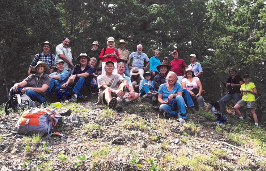
Green Mountain kimberlite pipe, Boulder Colorado
July 27, 2013
Leader: Pete Modreski, USGS
A short day hike to visit the most accessible and best exposed kimberlite pipe in Colorado. The Green Mountain kimberlite is located within Boulder Open Space and Mountain Parks, between Flagstaff Mountain and Green Mountain. The hike to the site, starting at the “Realization Point” trailhead, is only about one mile each way, mostly via the Ranger and Greenman trails, but it does involve negotiating a fairly steep grass/dirt hillside off-trail to cross a side valley to the kimberlite outcrop. Total elevation climb on the hike is about 500 feet. The pipe forms a good outcrop, about 140 feet in diameter, surrounded by Boulder Creek Granodiorite. This pipe, age about 600Ma (?), is the southernmost kimberlite of the State Line Kimberlite District, and is the only kimberlite of the district in which diamonds have not been confirmed to have been found. The classic kimberlite indicator minerals, pyrope garnet, chrome diopside, and magnesian ilmenite, can be seen in the rock.
Recap of CSS 2013 Summer Field Trip by Pete Modreski
About 24 of us met in Boulder the morning of July 27 to hike to the Green Mountain kimberlite pipe. Our CSS folks were joined by some members of the Florissant Scientific Society. We had a pleasant hike up through the woods, everyone reached the pipe (and made it back too), and this group photo shows our crowd, all sitting/standing on the small knob formed by the outcrop of the pipe, which underlies the small clearing within the otherwise mostly forested mountainside. We were back at the Realization Point trailhead at 1 p.m., just as promised. A few of us enjoyed a side stop on the drive back down from Flagstaff Mountain; a rhyodacite sill intruded into the Fountain Formation, nicely exposed at the Crown Rock trailhead.
Trail directions to Green Mountain kimberlite
=
2012
Catastrophic Glacial Outburst Floods on the Upper Arkansas River
Field Trip from Leadville to Buena Vista – September 29, 2012
Leaders: Keenan Lee and Cal Ruleman
The Floods
During the Pleistocene, glaciers from the Sawatch Range flowed down three contiguous tributary valleys to the Arkansas River near Granite, Colorado. The Lake Creek glacier probably pushed the Arkansas River out of its channel, and the Clear Creek and Pine Creek glaciers crossed the river and rammed into granite walls on the far side of the valley. These glaciers formed an ice dam about 670 ft high that blocked the Arkansas River and created a large lake about 600 ft deep that extended 12 miles upstream below Leadville.
When the ice dam broke, the lake drained catastrophically. The outburst flood tore out the ends of the moraines and carried the detritus down the valley in a torrent of dirty water that deposited a sheet of flood boulders 60 ft thick in less than a day. Many flood boulders are tens of feet in diameter, and some can be found 150 ft up on the valley wall.
At least four catastrophic floods swept the Upper Arkansas Valley, together called the Three Glaciers Floods. Field evidence documents well the last two floods, but only patches of older flood boulders attest to two earlier floods. The most recent flood dates to the Last Glacial Maximum, or Pinedale age, with a cosmogenic age of 17-19 ka. The oldest flood is older than 760 ka, and the second flood is older than 640 ka. The age of the third, or penultimate, flood is currently under debate. Perhaps field trip participants can judge the field evidence and contribute to a solution.
The Field Trip
The trip will begin in Leadville and cover 50 miles with 10 stops, ending in Buena Vista. Stops will include overviews of the three glacial systems, a view of the glacial damsite from atop a lateral moraine, ice-rafted boulders at the shoreline of Three Glaciers Lake, flood boulder deposits, flood boulders 150 ft above the modern Arkansas River, remnants of the two oldest floods, and the granddaddy flood boulder 61 ft long.
Look at the flyer: CSS_Glacial Flood on Arkansas flyer, Sept-2012
The field trip guide with high-res illustrations: CSS Glacial Flood on Arkansas River, Trip Guide, Sept-2012 (PDF 8.1 MB)
The Geology of the Upper Arkansas Valley, 2018 Field Trip also explored this area and events.
=
Family Friendly CSS Field Trip – Pegmatites near Harris Park, July 2012
Leader: Pete Modreski, USGS
On Saturday, July 21, about 15 CSS members and friends (including a couple of children) met to collect pegmatite minerals near Harris Park, Colo. Our destination was pegmatite mining claims belonging to the Littleton Gem and Mineral Club, and our visit was courtesy of that club. CSS President Pete Modreski (also a member of the Littleton mineral club) led the trip. The site is at about 9000’ elevation in Pike National Forest, north of US-285, and lies at the foot of the “Pegmatite Points” ridge east of Rosalie Peak. It lies within an offshoot of the Pikes Peak batholith, formerly known as the Rosalie Lobe (until it was discerned that the granite on Mt. Rosalie is really part of an older pluton) and now called the Lone Rock pluton, believed to be a cupola connected to the main Pikes Peak batholith at depth. Small pegmatite dikes cut through the granite on the wooded hillsides, and are host to crystals of smoky quartz and microcline; some of the feldspar is the blue-green variety, amazonite, for which Colorado is famed for among mineral collectors. Associated minerals can include albite, fluorite, topaz, goethite, hematite, and others.
A few people in the group found good specimens of quartz crystals, some of which were smoky and some not, plus microcline crystals and small amounts of fluorite. The elusive amazonite wasn’t much in evidence, beyond a few cleavage scraps left behind from previous “digs,” nor was any topaz found. But it was a beautiful day and all had a good time, and the small creek to ford just before reaching the claim site proved passable for everyone’s vehicles!
President’s Message, by Pete Modreski
=
Cumbres and Toltec Scenic Railroad Geology Train Excursion, June 2012
On Sunday, June 24, the Cumbres & Toltec Scenic Railroad operated a special train from Antonito, Colorado, to Chama, New Mexico, specifically for geologists. This train stopped at many outcrops and cuts along the right of way to allow geologists to mingle, take photographs, and collect rock samples.
=
2011
Geology of the Western San Juan Mountains
CSS Fall 2011 Field Trip
September 30 to October 2, 2011
Leader: George Moore
George led us from Ouray, to Ironton, then over Red Mountain and down to Animas Forks on 4-wheel drive roads, down to Silverton, and back to Ouray. This was through the heart of the Silverton Caldera, learning about the geologic and mining history of the area.
CSS Fall 2011 Field Trip on Geology and Mining History of the Western San Juan Mountains
Pictures of Fall 2011 field trip to Western San Juans
=
Late Cenozoic Evolution of the Colorado Rockies, May 2011;
Evidence for Neogene Uplift and Drainage Integration and New Insights into the
Cambrian-Devonian Depositional Systems and Paleoenvironments of Western North America
2011 CSS Spring Field Trip, May 6–7, 2011
Leaders: Andres Aslan, Mesa State College, Grand Junction, Colo.
Paul Myrow, Colorado College, Colorado Springs, Colo.
Where: Glenwood Springs and the Colorado River corridor
This Spring’s field trip will involve exploring the late Miocene to present geomorphic evolution of the Colorado River system as well as take a look into paleoenvironments of much greater antiquity of the Cambrian to Devonian record. The Colorado River system, as the single river system that drains the western slope of the Colorado Rocky Mountains, is a sensitive gauge of the uplift history and landscape evolution of the western U.S. The first part of this trip focuses on the Upper Colorado River basin and evaluates the hypothesis that the river system and modern Colorado Rockies are being shaped by neotectonic epeirogenic uplift, interacting with climatic and geomorphic forcings. The view presented here is that this epeirogenic uplift is primarily related to mantle buoyancy and, to a lesser extent, isostatic adjustments, caused by regional denudation.
Andres will lead us to stops in the upper Colorado River basin. These will include 1) Lookout Mtn. to view the remnants of the late Miocene paleo-land surface that records the start of regional denudation in the Colorado Rockies, as well as river gravels interpreted to represent a ca. 10 Ma ancestral Colorado River, 2) Glenwood Canyon to discuss the canyon’s incision history, and 3) Dotsero to view the Lava Creek B tephra associated with ca. 640 ka ancestral Colorado River gravels. This last stop involves a short hike with about 350 ft of elevation gain.
Together with Paul, we will first visit a section that exposes rocks of the Upper Cambrian Dotsero Formation. It includes a variety of shallow marine facies typical of the Cambrian inner detrital belt of North America, namely shale, peloidal grainstone, and flat-pebble conglomerate. The grainstone contains evidence for traction transport and deposition under stormgenerated oscillatory currents (e.g., small-scale hummocky cross-bedding). The flat-pebble conglomerate is also considered to be a product of storm deposition. We will examine a variety of unusual and enigmatic synsedimentary deformation structures in these facies and discuss their possible origins. In addition, we will look at a regionally extensive stromatolite bed, the Clinetop Stromatolite, and associated features. Conodont and trilobite data on these deposits will be presented, as well as evidence for a disconformity in the vicinity of the Clinetop bed. We will then walk through the lowermost Ordovician Manitou Formation, a unit dominated by fine grainstone. At the top of the unit, there is a prominent disconformity with Upper Devonian strata of the Chaffee Group, the lower Parting Formation. This part of the section contains quartz sandstone, shale, and minor limestone beds, as well as many unique features including halite casts, early fish fossils, and a variety of different types of cross stratification. A conspicuous transgressive sandstone with dune-scale cross stratification and abundant Skolithos trace fossils is overlain by a paleo flooding surface that underlies muddy open marine carbonate of the Dyer Formation. We will examine a paleokarst higher in the unit that may represent the Late Devonian Hangenberg Event. Carbon isotopic data on the section will be provided that show a major positive isotopic excursion associated with this bed.
Pictures of 2011 Spring field trip to Glenwood Canyon
=
2010
Aspen region and Grand Loop Field Trip — A Tribute to Bruce Bryant
September 24–26, 2010
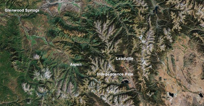
This Fall’s field trip will entail a geologic journey into Bruce’s old stomping grounds and go out to Glenwood Springs, up through Aspen, and back around over Independence Pass and through the Upper Arkansas River Valley. We plan to look at a variety of geologic topics and disciplines from the Proterozoic to the Quaternary. Geologic highlights will include the geology of the Maroon Bells, spectacular glaciated valleys, Quaternary geology of the Roaring Fork Valley, and the Oligocene Grizzly Peak caldera. We plan to stay in Glenwood Springs the first night. The second night will be around Aspen, with a motel or camping option. Aspens should be in peak color at the time of the trip as well.
Pictures from 2010 Fall, Aspen region field trip honoring Bruce Bryant (3.4 MB)