Talks at Colorado Scientific Society Meetings in 2021
January
Snowmastodon Fossil Dig: A Love Story
Thursday, January 21, 2021
Christian and Becky Shorey, Colorado School of Mines and Jefferson County Public Schools
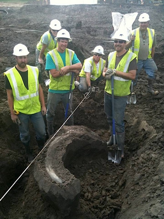
Abstract: In 2010 workers at the Snowmass Department of Water and Sanitation discovered a mammoth while digging a new dam for water storage. Members of the Denver Museum of Nature and Science rushed to the site and were able to uncover ice-age bison, and mastodon fossils before the ground froze as the calendar turned to 2011. With the spring thaw, volunteer crews working with DMNS dug an enormous fossil trove in a constrained seven week period. Christian and Becky, newly engaged, joined weeks 3 and 5, and using video shot by Christian and Becky’s photos, this talk will summarize what they saw and learned in that time. We will take you back to the last glacial period and into the previous interglacial times of alpine Colorado, and even future possibilities.
Our Speakers
Biographies: Becky and Christian Shorey both got into geology at a young age through dinosaurs, but did not meet until ten years ago.
Becky Shorey, who has a bachelor’s degree in Earth and Atmospheric Science and one Masters in secondary education and will graduate with a second masters in Educational Leadership in April. She recently left her long-term position teaching earth science in Jeffco, to manage the county’s one-to-one TechforEd program where each student is issued a personal device for learning. In her spare time, she is a contract worker for the EdTechTeam which specializes in teaching teachers how to integrate technology into the classroom to transform education. Becky has an accomplished resume of photography, and took almost all of the still images seen in this presentation. Her long-standing love of dinosaurs and paleontology is demonstrated by her nickname, Beckasaurus.
Dr. Christian Shorey is a teaching professor at the Colorado School of Mines, and though his specialty is paleoclimatology, his love of earth science started with dinosaurs and other fossils. Christian is a teaching professor and Program Manager for the GE dept at the Colorado School of Mines, and teaches almost 1000 students/year, mostly through our 101 class, which he runs with the help of a cadre of TAs. Christian produced the Earth and Environmental Systems Podcast and is currently producing episodes of the Earth Explorations video series. Christian has been carrying video equipment into the field for decades to document aspects of field geology. The footage you will see is some of the last that particular camera took before the field conditions killed it.
View the Recording of our CSS January Zoom meeting:

No passcode is needed to access this recording. Just click on the video.
Duration: 1:09:02
DISCLAIMER & FAIR USE STATEMENT: This Zoom-meeting recording contains content that expresses the opinions, viewpoints, and conclusions of the speakers and does not necessarily reflect the views, policies, or endorsements of the Colorado Scientific Society. This recording is made available to the public for general information and educational purposes only and is not intended to be used for profit. Any use of copyrighted material included therein for other purposes must obtain express written permission from the author.
=
February
Mechanical stratigraphy and layer-bound normal faulting:
Understanding the evolution and development of normal faults in the Upper Cretaceous Niobrara Formation, Wattenberg Field, Colorado
Thursday, February 18, 2021
Kyle Bracken, Geologist – Occidental Petroleum
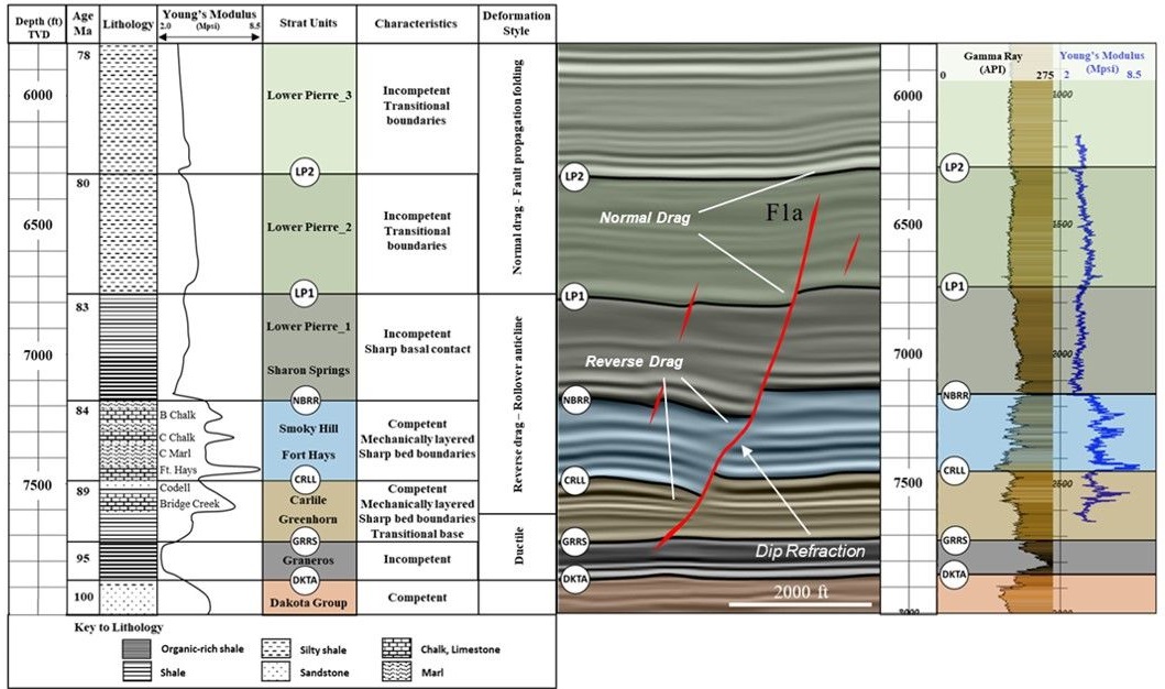
Abstract: The Upper Cretaceous section of the Denver Basin is littered with small-scale normal faults. Much of the previous work on this fault system has focused on the 3-D distribution of the faults and their relationship to other pre-existing tectonic features. This research focuses on the timing and propagation history of the faults and how that relates to the mechanically layered nature of the Niobrara Formation. 3-D seismic and well log interpretation reveal a complex, segmented fault system that is divided into two discrete tiers: an upper tier located in the Upper Pierre Shale, and a lower tier centered over the Niobrara Formation. Growth strata in the Lower Pierre Shale above grabens in the Niobrara Formation indicate that the faults were active during the deposition of the Pierre Shale and thus pre-date the formation of the upper tier of faults. 3-D analysis of fault plane geometry and throw show that fault segments are laterally well-connected near the top of the Niobrara Formation, forming linear arrays of linked grabens. Below, faults are less connected and show evidence of both lateral and vertical segmentation. In cross-section, fault planes are observed to change dip angle as they pass through rock layers with differing mechanical properties; refracting from ~55° in the more competent layers down to ~35° in the less competent layers. Field examples of normal faults that cut mechanically layered rock help better understand these geometries and provide reasonable inferences to their development and propagation history. In summary, it is argued that the mechanically layered nature of the Niobrara and Carlile formations is responsible for many of the fault characteristics described and provides valuable insight into the evolution of the fault system.
Speaker’s Bio: Kyle earned a B.S. in Geoscience from the University of Iowa in 2010 and began working as a mud logger (well site geologist) for Columbine Logging in Colorado the following year. In 2012 he joined Anadarko Petroleum (Denver) as an Operations Geologist. Over the span of his career with Anadarko, and now Occidental Petroleum, Kyle has geosteered over 300 horizontal wells across the Rockies Region including projects in the Powder River, Sand Wash, Washakie, Green River, and Denver basins. More recently he has specialized in seismic interpretation, well planning, and structure mapping in support of Occidental’s drilling programs across the Rockies. Kyle has a passion for the outdoors and enjoys taking in Colorado’s beautiful geology while fly fishing and mountain biking.
This Zoom meeting was NOT recorded due to the confidentiality of the data presented.
=
March
Old Faithful Anatomy and Magma from Earth’s Core Fueling The Volcanism of Yellowstone, Its Geysers and Hot Springs
Thursday, March 25, 2021
Robert B. Smith (Bob Smith)
Distinguished Professor
Department of Geology and Geophysics
University of Utah
Founder, Principal Investigator and Coordinating Scientist, Yellowstone Volcano Observatory, and Yellowstone-Teton-Utah Seismic and GPS Networks,
and
Jamie Farrell
Assistant Research Professor
University of Utah Seismograph Stations
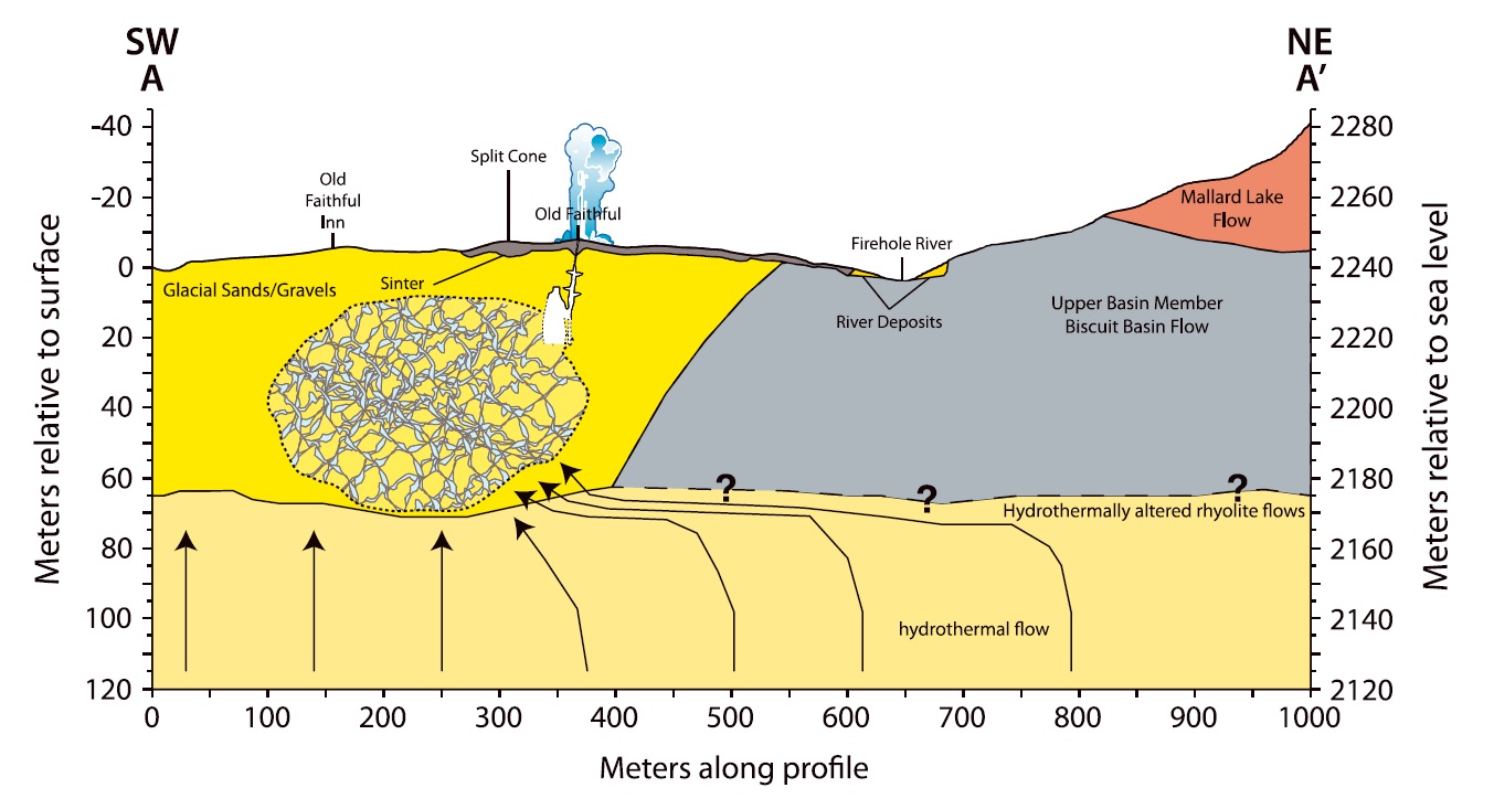
Figure 4 from Anatomy of Old Faithful From Subsurface Seismic Imaging of the Yellowstone Upper Geyser Basin , AUG Research Letter 10.1002/2017GL075255.
“The interpreted of the Old Faithful geyser plumbing system based on the results of this study. Our working model is constrained by nearby geological structure based on geological mapping and previous drilling results (Christiansen, 2001; Fenner, 1936; Muffler et al., 1982; Vandemeulebrouck et al., 2013; White et al., 1975). This cross section follows the AA0 white line in Figure 1. The ascending hydrothermal flow is assumed to be redirected by the impermeable Biscuit Basin flow to the highly fractured and porous medium west of the glacial deposit/rhyolitic lava boundary. Dashed lines with question marks are inferred based upon hydrothermal models and mapped geology.”
Abstract: Old Faithful Anatomy and Magma from Earth’s Core Fueling The Volcanism of Yellowstone, Its Geysers and Hot Springs
Bob Smith’s University of Utah research group has monitored Yellowstone since 1983 and continues conducting earthquake, crustal structure and GPS studies as well as continuous real-time monitoring of the world’s largest volcano and its tallest geyser, Steamboat. Moreover, we have conducted detailed seismic, GPS and geologic studies of the anatomy of Old Faithful the world renown and iconic Yellowstone geyser to determine its 4D structure and dynamic plumbing and eruption properties. These studies reveal that Old Faithful is located at the top of a large hydrothermal reservoir only 10 to 60 m deep that is composed of highly fractured rock, hot water and steam located west of the geyser and extending a km beneath the Old Faithful Lodge and other infrastructure. We discovered that Old Faithful eruptions do not have a notable seismic signal but large precursory seismic signals of harmonic tremor every 95 minutes just prior to the eruption and from which we can now predict within seconds. I will also show the initial results from seismic monitoring and imaging of Steamboat Geyser, the world’s tallest geyser and of the northern Yellowstone Lake hydrothermal system. Moreover, we show how Yellowstone’s immense volcanic system is part of a giant Earth’s mantle convection cell originating 1800 miles deep at the core-mantle boundary creating a magmatic plume of partly molten rock rising in a conduit upward to 50 miles deep beneath the North American continent which that then intrudes the lithosphere and fuels magma into two magma reservoirs as shallow as 2-3 miles beneath Old Faithful. Overall these studies demonstrate the geodynamics of the entire 300 mile wide Yellowstone Plateau created by magma-plume buoyancy and that has had a profound impact on the geologic evolution of entire western U.S. since Yellowstone volcanism began 500 miles west of Yellowstone National Park as the mantle plume interacted with the bottom of the North American continent that moved SW at 2.5 cm/yr. 16 million years ago across Idaho, Oregon and Washington.
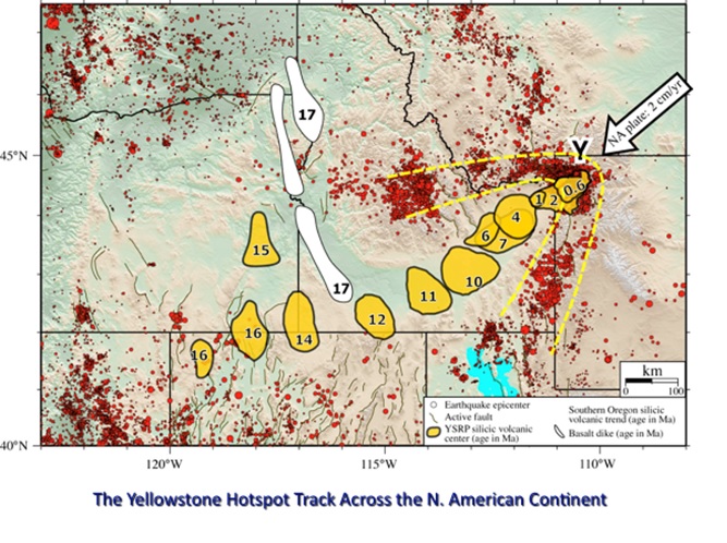
See also Anatomy of Old Faithful From Subsurface Seismic Imaging of the Yellowstone Upper Geyser Basin for more information.
Biography: Professor Robert B. Smith has a distinguished career in geophysics working on earthquake, crustal deformation and education and outreach throughout his career. BS and MS Utah State Univ. PhD University of Utah, Post Doc Columbia University, Visiting Professorships Swiss Federal Institute of Technology and Cambridge University.
Bob Smith has been working in Yellowstone for 63 years, beginning in 1956 even before college. He has been a Geophysics Professor at the University of Utah for 52 years leading a research group of scientists and students working on the dynamics of earthquake and volcano and dynamics of the western American Plate. And Bob has supervised 69 graduate students and dozens of Post Docs and Visiting Professors.
Professor Smith served as a Post-Doctoral Scholar at Columbia University, conducted collaborative research as a Guest Professor at the Swiss Federal Institute of Technology for 6 years, and spent a year at Cambridge University studying. His European geophysical and geodetic studies including the evolution and structure of the Alps, Greece, Italy and Mediterranean Sea.
Bob served in an Antarctic expedition as the U.S. Exchange Scientist to the British Antarctic Survey, 1962-63 conducting geophysical surveys of the continent working out of the Halley Bay science station. For his research and service, he received the British Antarctic Survey Gold Emblem and the U.S. Antarctic Medal.
Institution founding, Bob co-founded several major U.S. research institutions including IRIS (Institutions for Research In Seismology), UNACO (University NAVSTAR Consortium for GPS and Geodesy), co-founder and chairing the Southern California Earthquake Center Science Advisory Committee and was the principal founder of the highly successful EarthScope Project.
Bob has served on numerous university, state and federal advisory committees.
This included presentations for the prestigious for the U. S. Senate and House Committees on Science and Technology, 2008 and 2009.
Also Bob has received numerous U.S. and European awards and medals, and continues his Yellowstone research where he makes discoveries every year and where he treats Yellowstone-Teton geology as a living, breathing, shaking and baking natural laboratory.
Bob’s Book With Co-Author Lee Siegel: “Windows Into The Earth: The Geologic Story of Yellowstone and Grand Teton National Parks, Oxford Univ. Press, 2000, is the most popular geology book on these parks and has sold ~30,000 copies.
Intuition Service: Served on numerous committees of the National Academy of Sciences Committee on Seismology, Yellowstone Deep Drilling, Geology, Geophysics and on my contributions to the Yellowstone science. Served on NSF National Advisory Council and on numerous NSF Committees: Geophysics, Active Tectonics, Geology, Computational Earth Science, etc.
Convener of dozens of National and International Meetings and Workshops
Bob Smith’s University of Utah Laboratory: The University of Utah Seismology and Active Tectonics Research Group with loads of our data links: www.uusatrg.utah.edu/index.html
Bob Smith’s Research Data Links: University of Utah Yellowstone-Teton real-time earthquake map: http://quake.utah.edu/earthquake-center/quake-map
Yellowstone-Teton GPS measured ground movements from University of Utah and other GPS stations, borehole strain/tilt data and Lidar via the GAGE UNAVCO data archive: https://www.unavco.org/what-we-do/
The Recording of our CSS March Zoom meeting has expired from the Colorado School of Mines Zoom repository.
=
April
Fluvial deposits of the Raton Basin:
Implications for Late Cretaceous-Paleocene paleogeography and climate in the southern Rockies
Thursday, April 15, 2021
Theresa Schwartz, U.S. Geological Survey and Colorado School of Mines
Abstract: The Raton Basin of Colorado-New Mexico, USA, is the southeasternmost basin of the Laramide intraforeland province of North America. It hosts a thick succession (4.5 km or 15,000 ft) of Upper Cretaceous to Paleogene marine and continental strata that were deposited in response to the final regression of the Western Interior Seaway and the onset of Laramide intraforeland deformation. The Upper Cretaceous-Paleogene Raton and Poison Canyon Formations were previously described as meandering and braided river deposits that represented distal and proximal members of rivers that drained the basin-bounding Sangre de Cristo-Culebra uplift. This talk presents new observations of fluvial channel architecture that show that both formations contain the deposits of sinuous fluvial channels. However, they differ: Fluvial channels of the Raton Formation formed in ever-wet environments and were affected by steady discharge, whereas channels of the overlying Poison Canyon Formation formed in drier environments and were affected by variable discharge. The apparent transition in fluvial discharge characteristics was coeval with the progradation of fluvial fans across the Raton Basin during the Paleocene, emanating from the ancestral Sangre de Cristo-Culebra uplift. The construction of fluvial fans, coupled with the sedimentary features observed within, highlights the dual control of Laramide deformation and early Cenozoic climate patterns on the sedimentary evolution of the Raton Basin.
Biography: Theresa Schwartz is a research geologist at the U.S. Geological Survey in Denver, Colorado, housed in the Geosciences & Environmental Change Science Center. She is a clastic sedimentary geologist interested in tectonics and sedimentary basins with a broad research program that focuses on (1) sedimentology and stratigraphy of depositional environments, (2) understanding sediment routing within and between those settings, and (3) understanding tectonic and climatic drivers of sedimentation and paleoenvironmental change. To address these topics, Theresa uses a combination of field and geochemical methods including field mapping at various scales, sediment provenance techniques (e.g., petrography, detrital zircon analysis, bulk rock geochemistry), and paleoenvironmental analysis (e.g., stable isotope stratigraphy). Theresa received her BS in Geology at Allegheny College and her PhD in Geological & Environmental Sciences at Stanford University.
The Recording of our CSS April Zoom meeting has expired from the Colorado School of Mines Zoom repository.
=
May
Reflections of Mars:
Using Orbital Radar Observations to Discover Climate Signals and More
Thursday, May 13, 2021
Dr Isaac B. Smith,
Assistant Professor, York University
Research Scientist, Planetary Science Institute
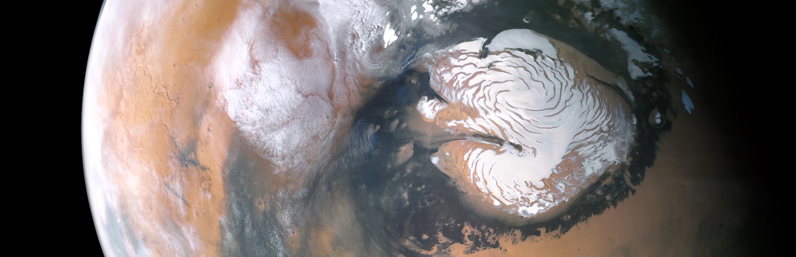
click on it for a detailed 2.9 MB image
Abstract: The layered deposits at Mars’ north and south poles have long been thought to contain a record of climate related to ice deposition. Radar observations from Mars Reconnaissance Orbiter have contributed immensely to our toolkit for studying those layers, and we are starting to better understand how climate signals are recorded in the ice caps. In this talk I will introduce polar cap stratigraphy and present evidence for two climatic shifts, one using H2O ice on the north pole that details a glacial/inter-glacial cycle, and another looking at periodic CO2 deposition from partial atmospheric collapse in the south. I’ll also discuss flowing ice, migrating spiral troughs, and a new, solid interpretation of bright reflectors under the south polar cap that have been thought to be the result of liquid water. This talk will include many pretty pictures.

Brief Bio: Dr Isaac B. Smith,
Currently Assistant Professor and Canada Research Chair at York University in Toronto
Currently Research Scientist at the Planetary Science Institute (Since 2017, part time since 2018)
2016-2017 Postdoc at Planetary Science Institute in Lakewood, Colorado
2014-2016 Postdoc at Southwest Research Institute in Boulder, Colorado
2013-2014 Fulbright Scholar at Sorbonne University in Paris
2013 completed a Ph.D. in Geosciences, focus planetary science, from the University of Texas at Austin
2007, finished my M.S. in Physics at UMSL, including 1 year in Stuttgart, Germany
2001, B.S. in Physics at Southwestern University in Georgetown, Texas
View the Recording of our CSS May Zoom meeting:
No passcode needed to access this recording. Just click on the video.
Duration: 1:08:55
DISCLAIMER & FAIR USE STATEMENT: This Zoom-meeting recording contains content that expresses the opinions, viewpoints, and conclusions of the speakers and does not necessarily reflect the views, policies, or endorsements of the Colorado Scientific Society. This recording is made available to the public for general information and educational purposes only and is not intended to be used for profit. Any use of copyrighted material included therein for other purposes must obtain express written permission from the author.
=
September
Colorado Scientific Society 2021 Past Presidents’ Dinner
A Voyage Through Time: Ancient Landscapes and Seascapes of the Earth and Beyond
Thursday, September 16, 2021
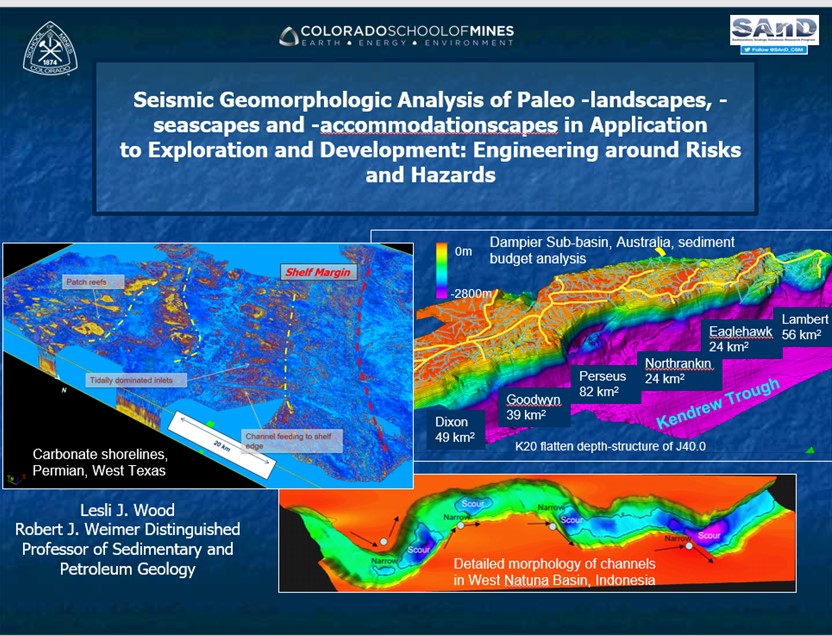
Professor Lesli J. Wood
Robert J. Weimer Distinguished Professor of Sedimentary and Petroleum Geology
Colorado School of Mines
The Dinner and presentation was at the Mount Vernon Canyon Club, (on Lookout Mtn., off I-70)
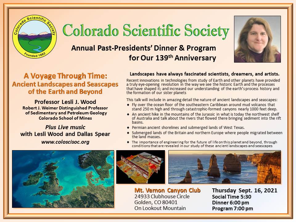
Abstract: Landscapes have always fascinated scientists, dreamers and artists. Development post WWII of our ability to image beneath the waves revealed the beautiful aqua terra that additionally existed in our ocean floors. The development in the 90s of seismic geomorphologic mapping of paleo-landscapes and -seascapes was truly an eye-opening revolution in the way we see the historic Earth and the processes that have shaped it. To understand the landscapes and seascapes that we live on and how our lands will change as the Earth changes, is to control our own ability to engineer solutions on this and other planets to those changes. This talk will document in amazing detail the nature of ancient landscapes and seascapes using 3D seismic images and remotely sensed data from other planets. We will fly over the ocean floor of the southeastern Caribbean around mud volcanos that stand 250 m high and through catastrophic-formed canyons nearly 1000 feet deep. We will take an ancient hike in the mountains of the Jurassic in what is today the northwest shelf of Australia and talk about the rivers that flowed there bringing sediment into the rift basins. We will look at the Permian ancient shorelines and submerged lands of the West Texas and will exam the submerged lands of the Britain and northern Europe where people migrated between the land masses. This talk will show you the revolution in our understanding of the earth’s process history and the formation of our sister planets, born through the past 30 years of application of digital geomorphologic analysis of systems. Finally, we will talk about the importance of engineering for the future of life on this planet and beyond, through conditions that are revealed in our study of these ancient landscapes and seascapes.
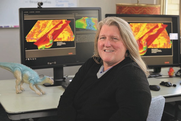
Lesli Wood grew up running around the hills and creeks of central Arkansas. By the time she was a junior in high school, she already knew she wanted, to major in geology at Arkansas Tech University. “We backpacked several times through the Wind River Range in Wyoming, and we camped in the Medicine Bow Mountains,” she said. “I was immersed in nature and looked for an occupation that would allow me to be in nature. I also grew up liking mysteries. Geology is the study of the mysteries of earth and other planets, so it was the perfect science”.
Wood received her master’s degree in geology from the University of Arkansas and her PhD in earth resources from Colorado State University. In 1992, she began working at Amoco Corporation in Texas. Her position coincided with the company’s revolution in paleo-landscape imaging through the development of coherency and spectral decomposition. It was there that she began to appreciate geomorphology Martian deltas; deep-water landslides and sedimentation processes; and fluvial, deltaic, and shallow marine sands and reservoir systems.
Most recently, Wood has been fascinated with researching sea-floor landslides. “Up to 70 percent of the fill in some of the ocean basins around the world consists of huge landscape deposits,” she said. “Some of the largest tsunamis that happen in the world are because of landslides that perturb the seafloor. As companies explore the ocean floors, we have to be concerned with a lot of natural hazards, including landslides, as well as concern ourselves with the impact we can have on the seafloor.”
When Wood isn’t researching sea-floor landslides, shale tectonics and mud volcanoes, she is practicing with her band, or creating her own music.
There was also live music with Lesli Wood and Dallas Spear.
Poster for 2021 Colorado Scientific Society Past Presidents’ Dinner
We do not have a video recording of the presentation at the Colorado Scientific Society 2021 Past Presidents’ Dinner.
=
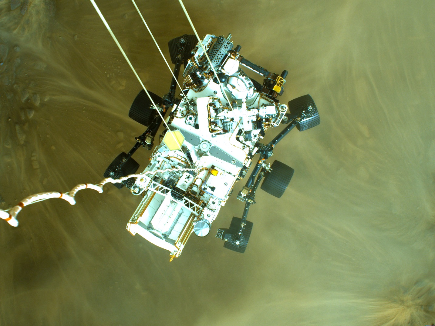
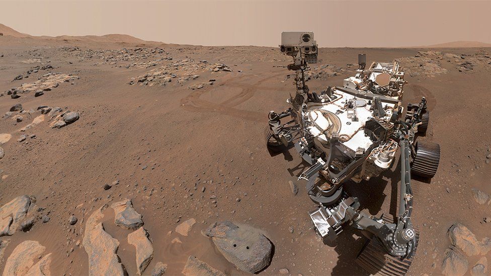
October
Colorado Scientific Society 2021 Emmons Lecture
Eight months of Perseverance on Mars
Thursday, October 21, 2021
Ken Farley
Professor of Geochemistry at the California Institute of Technology (Caltech) and
Project Scientist for the Mars 2020 Perseverance mission.
The link for a video of the meeting is after the images, Abstract and Bio.

Click here for a high resolution image of the Jezero Crater.
This was an online Zoom-only meeting, and the talk started at 7:00 pm.
To watch a video of the meeting, see link below after meeting info.
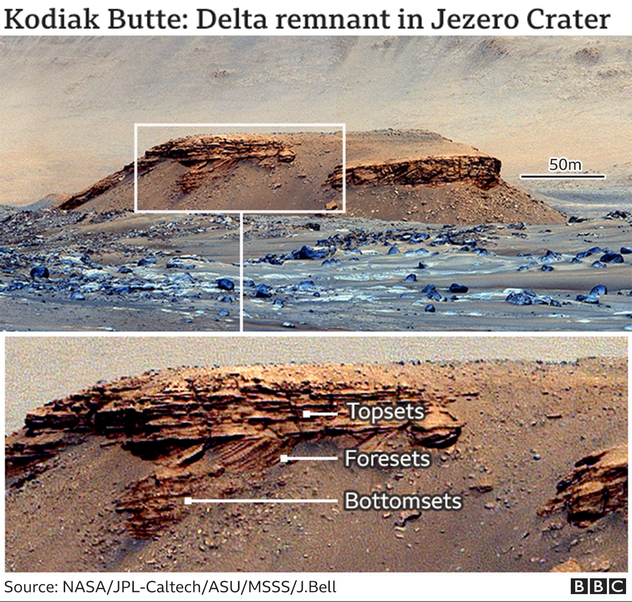
Click here for a high resolution image of Kodiak Butte’s beds.
Abstract: The Perseverance rover landed on Mars on February 18, 2021 on the floor of a crater that held a deep lake about 3.5 billion years ago. The mission’s goals are to interpret the rocks deposited on the crater floor, seek evidence of possible ancient life recorded in those rocks, and prepare a collection of rock samples for possible return to Earth by future missions. I am Project Scientist for the mission, and in this talk I’ll explain this mission’s motivations and activities in its first eight months, as well as describe my personal experiences with this enormous undertaking.
Ken Farley is the W.M. Keck Foundation Professor of Geochemistry in the Division of Geological and Planetary Sciences at the California Institute of Technology. His research centers on development and application of geochemistry techniques, especially involving isotopes of the noble gases, to a wide range of terrestrial and solar system questions. Specific areas of interest include geochronology of both Earth and Mars, the geochemical evolution of the Earth, and the behavior of noble gases in minerals. He is currently Project Scientist for the Mars 2020 Perseverance mission. He received a Bachelor of Science degree in chemistry from Yale University in 1986 and a doctorate in Earth Science from the Scripps Institution of Oceanography, University of California San Diego, in 1991. He began his professorial career at Caltech in 1993.
View Zoom Recording of “Eight months of Perseverance on Mars”
Watching this video is best in full screen. (This may sharpen up images.)
No passcode is needed to access this recording. Just click on the video.
Duration: 1:26:07
DISCLAIMER and FAIR-USE STATEMENT: The following Zoom-meeting recording contains content that expresses the opinions, viewpoints, and conclusions of the speakers and does not necessarily reflect the views, policies, or endorsements of the Colorado Scientific Society. This recording is made available to the public for general information and educational purposes only and is not intended to be used for profit. Any use of copyrighted material included therein for other purposes must obtain express written permission from the author.
=
November
Geology, Geopolitics, and Economics:
An overview of the risk to critical mineral supply chains
Thursday, November 18, 2021
Jamie Brainard
Material Flow Analyst at the National Minerals Information Center, U.S. Geological Survey.
The link for a video of the meeting is after the images, Abstract and Bio.
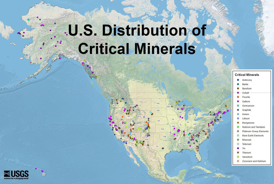
Abstract: The recent renaissance in critical minerals has been fueled by recognition that many commodities have an elevated risk of supply disruption. Factors including production concentration in a small number of nations, a heavy reliance on imports to meet consumption, and production as by-products of major commodities have all been considered for explicitly defining what makes a commodity “critical.” I will explain the approach taken by the U.S. federal government in identifying these materials, including the metrics used in our models. I will also provide some perspective on the supply chain challenges for critical minerals including extraction, trade, and recycling. I want to convey that the industrial, economic, and geopolitical challenges that currently exist for critical minerals are significant, but there are also many tools that could be employed to lower risk and ensure demand is met.
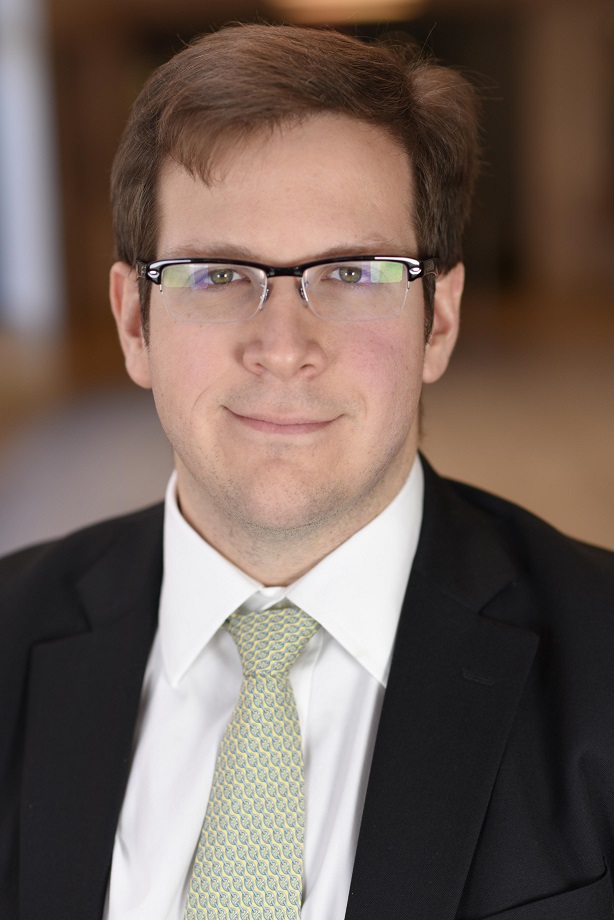
Biography: Jamie Brainard is a material flow analyst at the National Minerals Information Center at the U.S. Geological Survey. Jamie has a background as a geologist and astrobiologist studying the formation of hydrothermal ore deposits and Archean processes at Penn State, following receiving a Bachelor of Science in geosciences from Penn State in 2009. More recently, his work at the USGS has been focused on the identification and risk assessment of critical materials. This work on critical materials has been focused on the geologic accessibility of by-product commodities and on the international trade flows of commodities.
View Zoom Recording of “Geology, Geopolitics, and Economics: An overview of the risk to critical mineral supply chains”
Watching this video is best in full screen. (This may sharpen up images.)
No passcode is needed to access this recording. Just click on the video.
Duration: 1:11:52
DISCLAIMER and FAIR-USE STATEMENT: The following Zoom-meeting recording contains content that expresses the opinions, viewpoints, and conclusions of the speakers and does not necessarily reflect the views, policies, or endorsements of the Colorado Scientific Society. This recording is made available to the public for general information and educational purposes only and is not intended to be used for profit. Any use of copyrighted material included therein for other purposes must obtain express written permission from the author.
=
December
CSS Annual Meeting and President’s Address
Standing on the Shoulders of Giants:
Unraveling Salt Tectonics in the Eagle Basin
Thursday, December 16, 2021
Bruce Trudgill, Colorado School of Mines
The link for a video of the meeting and President’s Address is after the images, Abstract and Bio.
Standing on the Shoulders of Giants:
Unraveling Salt Tectonics in the Eagle Basin
R. Wes Pearigen II, Bruce Trudgill, Savannah Rice, Haley Thorson, Thomas Hearon IV* and Mary Carr
Dept. of Geology and GE, Colorado School of Mines, Golden, CO, 80401
*EOG Resources, Denver CO
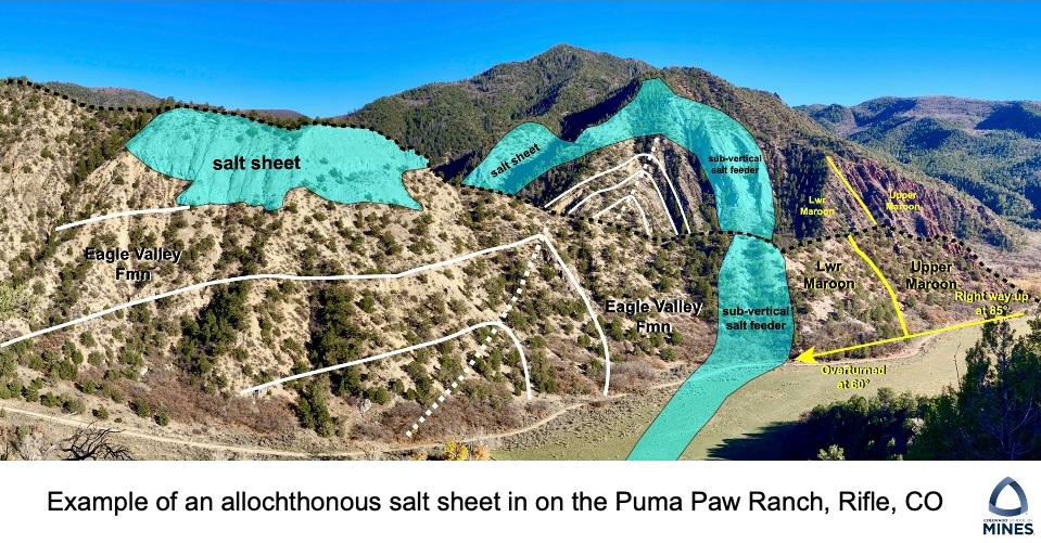
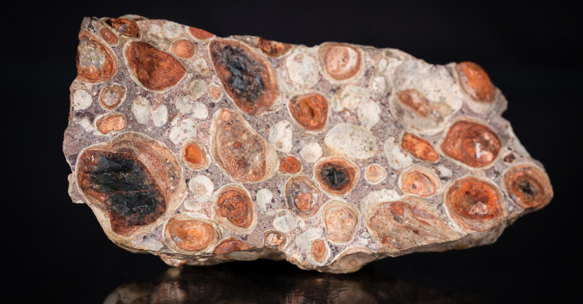
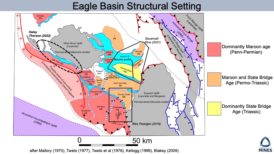
Abstract: Field mapping, measured stratigraphic sections, and restored cross-sections of the Eagle Valley Evaporite and overlying Late Pennsylvanian to Triassic aged strata indicate a long-lived phase of salt tectonics in the Eagle Basin, central Colorado. Diapiric salt structures represent formerly connected, polygonal salt walls flanked by deep, elongate minibasins. Previous work interpreted these structures to be the result of the Laramide Orogeny and younger tectonism; however, the proposed phase of salt-influenced deformation in the Eagle Basin suggests a new paradigm for the tectonic evolution of this region.
The late Paleozoic Eagle Basin formed as a flexural foreland basin, associated with the neighboring uplifts of the Ancestral Rocky Mountains. Cyclic flooding and desiccation of the Eagle Basin during Atokan-Desmoinesian time led to the deposition of a thick layered evaporite sequence containing cyclic deposits of halite, other salts, carbonates, and clastics of the Eagle Valley Evaporites.
Structural and stratigraphic analysis offers compelling evidence for long-term deformation compatible with salt tectonics prior to the Laramide Orogeny. The following features and interpretation support a prolonged salt tectonic history: (i) over-thickened, unconformity-bound strata contain abundant growth structures represent Permo-Triassic minibasins; (ii) linear structures cored by evaporite, in some places exposed at the surface, represent former diapiric salt walls that grew during Pennsylvanian through Triassic time between minibasins; and (iii) Laramide-age shortening resulted in basinal contraction and reactivation of secondary welds as thrust structures.
Building on the pioneering work of Ogden Tweto (CSS President 1952), Bruce Bryant CSS President 1985), this work has significant implications for the tectonic evolution of Central Colorado and salt-related features in the Eagle Basin are a new analog for salt systems that have undergone basement-involved shortening.
View Zoom Recording of “CSS 2021 Annual Business Meeting and
Unraveling Salt Tectonics in the Eagle Basin”
Watching this video is best in full screen. (This may sharpen up images.)
No passcode is needed to access this recording. Just click on the video.
Duration: 1:42:25
DISCLAIMER and FAIR-USE STATEMENT: The following Zoom-meeting recording contains content that expresses the opinions, viewpoints, and conclusions of the speakers and does not necessarily reflect the views, policies, or endorsements of the Colorado Scientific Society. This recording is made available to the public for general information and educational purposes only and is not intended to be used for profit. Any use of copyrighted material included therein for other purposes must obtain express written permission from the author.