Talks at Colorado Scientific Society Meetings in 2023
January
Colorado’s Evolving Landscape from the Neogene to Present: Insights from Geo- and Thermochronology
Thursday, January 19, 2023
Alyssa Abbey, California State University, Long Beach
Abstract: Colorado is host to a long and complex geologic history from Proterozoic accretion and terrane suturing, rifting in the Neoproterozoic and Cambrian, late-Paleozoic Ancestral Rock Mountain uplifts, to late-Mesozoic through early Cenozoic orogenesis. The region continues to evolve today and much of the landscape we see at present was shaped by relatively recent processes including the eruption of large volume ignimbrites that blanketed the surface from ca. 36-20 Ma. Initiation of the Rio Grande rift extension began ca. 25 Ma with continued fault initiation, growth, linkage, and exhumation progressing in pulses through ca. 5 Ma. The modern landscape is further defined by localized areas of high relief created by paleo and modern fluvial systems of which one of the most dramatic at present is the Arkansas River.
Analysis of low-temperature thermochronometric data in the northern Rio Grande rift (RGR) provides the means to assess the timing of fault initiation, as well as patterns in growth and linkage of rift faults. Apatite (U-Th-Sm)/He (AHe), zircon (U-Th)/He (ZHe) and apatite fission track (AFT) thermochronometric data combined into vertical transects and modelled in the program QTQt, reveal the detailed thermal histories useful for determining timing and rates of faulting in the northern RGR. Furthermore, initial detrital zircon U-Th-Pb data from samples in the Miocene-Pliocene Dry Union formation along with detailed stratigraphic characterization suggest a complex fluvial evolution of the modern and proto-Arkansas River indicating the potential that rift structures also played a role in evolution of the river.
Dr. Alyssa Abbey is an Assistant Professor in the department of Geoscience at California State University Long Beach (CSULB). She studied Geology and French at the University of Arizona and then completed her PhD at the University of Michigan researching continental rifting and fault growth using various geological dating methods. Her postdoctoral work, at the University of California, Berkeley, took her into new fields, studying active faults in Argentina, and water-rock interactions combining geochemistry, geochronology, and modeling. At CSULB, her research is split into research on tectonics and fault processes as well as geoscience education accessibility. Check out her children’s graphic novel on how mountains are made and change over time! (More information can be found on her website: alyssalabbey.com).
View Zoom Recording of “Colorado’s Evolving Landscape from the Neogene to Present: Insights from Geo- and Thermochronology”
Watching this video is best in full screen. (It may sharpen up images.)

No passcode is needed to access this recording. Just click on the video.
Duration: 01:12:37
DISCLAIMER and FAIR-USE STATEMENT: The following Zoom-meeting recording contains content that expresses the opinions, viewpoints, and conclusions of the speakers and does not necessarily reflect the views, policies, or endorsements of the Colorado Scientific Society. This recording is made available to the public for general information and educational purposes only and is not intended to be used for profit. Any use of copyrighted material included therein for other purposes must obtain express written permission from the author.
=
February
Mars Geology;
Stratigraphy, Sedimentology, and Diagenesis of a Martian Lacustrine Deposit, Murray Formation, Gale Crater, Mars
Thursday, February 16, 2023
Dr. John P. Grotzinger, Division of Geological and Planetary Sciences, California Institute of Technology
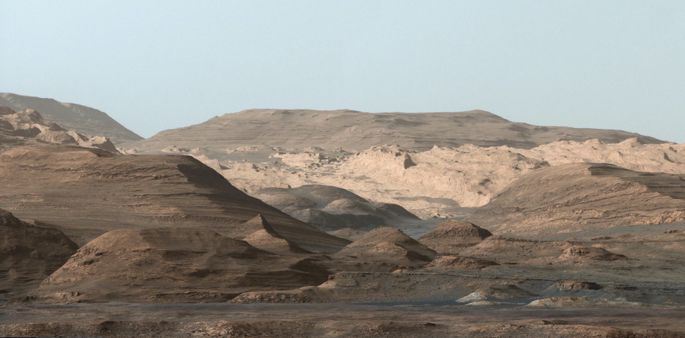
Abstract: The Mars Science Laboratory Mission’s Curiosity rover landed at Gale crater, Mars, on August 6, 2012. For the past ~9 years Curiosity has been exploring a lacustrine deposit exposed in dissected terrain of crater-interior central mountain. The lacustrine deposit (Murray fm., ~400m thick, early Hesperian age) overlies and is laterally equivalent to fluvial-deltaic deposits of the Bradbury group that Curiosity explored earlier in the mission. These rocks are unconformably overlain by the Stimson formation, an eolian sandstone that was deposited above a surface representing significant denudation of crater-filling strata. The Murray contains one major depositional facies – laminated mudstone – deposited in a lake; and minor additional facies – ripple cross laminated and trough cross bedded sandstones – representing subaqueous delta foreslope, fluvial, or eolian environments. The persistence of fine lamination, locally with scour and drape truncation surfaces, and general absence of desiccation cracks, prism cracks, intraclasts, displacive evaporite crystals and nodules, or bedded evaporites, all suggest a perennial lake with depths great enough to avoid seasonal desiccation. Intercalated thin sandstones, of potentially eolian or fluvial origin, might indicate base-level lowering during longer-term lake level oscillations or a period of normal regression. The mineralogy and chemistry of the lower Murray formation are explained by variations in the composition of fine clastic detritus delivered to the lake via marginal sediment plumes, coupled with redox oscillations in the composition of authigenic minerals precipitated from the lake. Stratigraphically higher members of the Murray, including those leading up to and comprising Vera Rubin Ridge and Glen Torridon regions, record elemental mobility during later diagenesis due to chemical weathering in an increasingly temperate paleoclimate as shown by feldspar alteration and phyllosilicate mineralogies. The early Hesperian environment at Gale crater is inferred to have recorded a persistently aqueous environment characterized by mild salinity and acidity. In that regard, Mars increasingly seems similar to Earth, where spatial variability in regional/global environments is as important to understand as temporal variability.
Dr. John P. Grotzinger is the Harold Brown Professor of Geology, Division of Geological and Planetary Sciences, California Institute of Technology. He was named chair of the Division of Geological and Planetary Scienes in June 2015. He served as chief scientist for NASA’s Mars Rover Curiosity mission and is currently a science Co-Investigator on the Perseverence Rover mission. Dr. Grotzinger’s research involves the comparative evolution of Earth and Mars in characterizing the origin and early evolution of life on Earth, and the search for biosignatures on Mars. He is a member of the US National Academy of Science, the American Academy of Arts and Sciences, and a recipient of NASA’s Outstanding Public Service Medal, and the Halbouty Award of the American Assocation of Petroleum Geologists. Dr. Grotzinger is a graduate of Hobart College (BS), the University of Montana (MS) and Virginia Polytechnic Institute (PhD). He served as a professor at MIT for 18 years, moving to Caltech in 2005.
View Zoom Recording of “Mars Geology;
Stratigraphy, Sedimentology, and Diagenesis of a Martian Lacustrine Deposit, Murray Formation, Gale Crater, Mars”
Watching this video is best in full screen. (It may sharpen up images.)
No passcode is needed to access this recording. Just click on the video.
Duration: 01:22:46
If you have a lower bandwith internet connection and have problems viewing the above video, here is the video at a lower bitrate: Mars Geology, lower bitrate
If you use this, please tell coloscisoc.webmaster@gmail.com about your experience.
DISCLAIMER and FAIR-USE STATEMENT: The following Zoom-meeting recording contains content that expresses the opinions, viewpoints, and conclusions of the speakers and does not necessarily reflect the views, policies, or endorsements of the Colorado Scientific Society. This recording is made available to the public for general information and educational purposes only and is not intended to be used for profit. Any use of copyrighted material included therein for other purposes must obtain express written permission from the author.
=
March
CSS Special Meeting on Earthquakes in Turkey
Breaking plates: how the recent earthquakes in Turkey relate to the tectonic escape of Anatolia and the migration of the Anatolia-Africa-Arabia triple junction
Tuesday, March 7, 2023
Michael Cosca, US Geological Survey
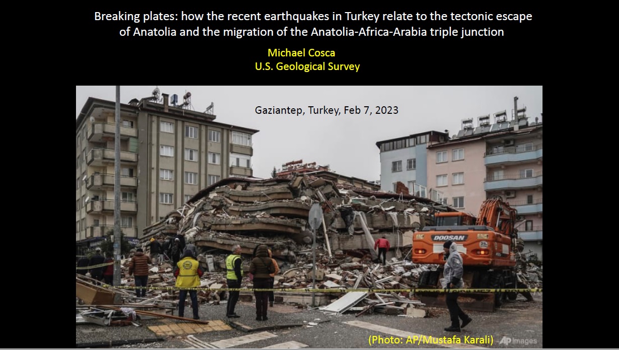
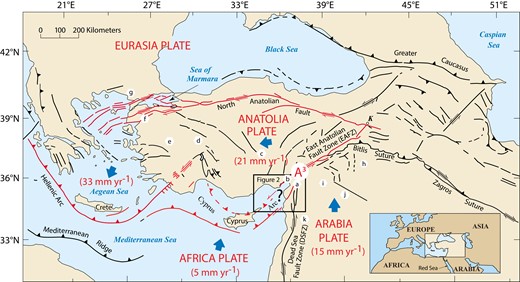
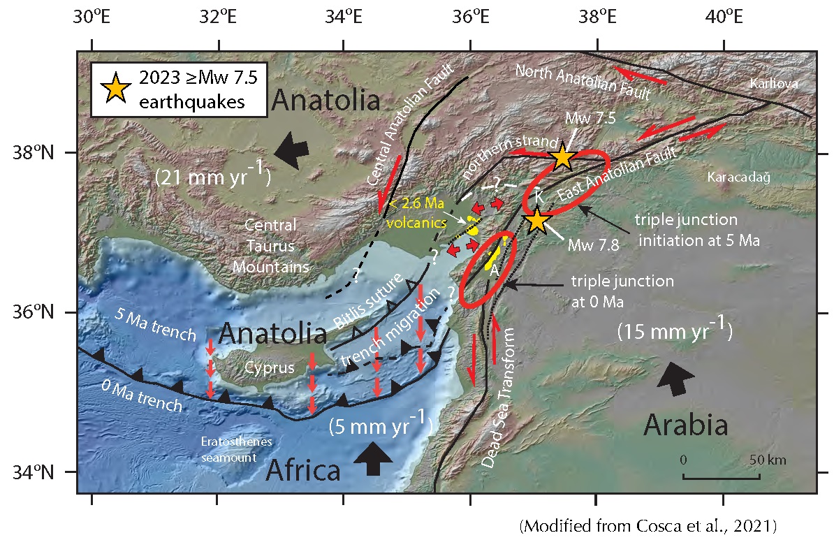
Abstract: During the early morning hours of February 6, 2023, a Mw 7.8 earthquake occurred in southern Turkey along the main strand of the East Anatolian Fault zone (EAFZ) followed 9 hours later by a Mw 7.5 earthquake along the northern strand of the EAFZ. The EAFZ, together with the North Anatolian Fault zone, bound an extruding wedge of Eurasia lithosphere (Anatolia microplate). The westward movement, or tectonic escape, of Anatolia at about 2 cm/year is controlled by collision (push) of Arabia into a ridged backstop (Eurasia) and concurrent extension (pull) within the Aegean and rollback of the Africa plate. The February 6 earthquakes, and numerous > Mw 5.0 aftershocks over the following days and weeks, are located near the migrating Anatolia-Africa-Arabia triple junction (Cosca et al., 2021). This is a region of active tectonism, seismicity, and plate reorganization, where the left lateral Dead Sea transform fault, separating Arabia from Africa, merges at its northern extent with the left lateral EAFZ, separating Anatolia from Arabia. Quaternary alkalic basaltic volcanism as young as 40 ka is closely associated with transform faults of the EAFZ. These observations, together with other information including seismic imaging, will be summarized and placed within a regional tectonic context.
Michael (Mike) Cosca is a research geologist with the U.S. Geological Survey in Denver, CO. He obtained his undergraduate degree from the University of California, Berkeley and his M.Sc. and Ph.D. from the University of Michigan. Mike spent nearly 20 years as a research professor at the University of Lausanne, Switzerland before coming to the USGS in 2008. He has broad research interests in mineralogy, petrology, regional tectonics, volcanism, ore deposits, and argon geochronology.
View Mike Cosca’s Citations re Turkey
View Zoom Recording of “Breaking plates: how the recent earthquakes in Turkey relate to the tectonic escape of Anatolia and the migration of the Anatolia-Africa-Arabia triple junction”
Watching this video is best in full screen. (It may sharpen up images.)
No passcode is needed to access this recording. Just click on the video.
Duration: 01:11:05
If you have a lower bandwith internet connection and have problems viewing the above video, here is the video at a lower bitrate: Earthquake in Turkey and Tectonics of Anatolian Plate, lower bitrate
If you use this, please tell coloscisoc.webmaster@gmail.com about your experience.
DISCLAIMER and FAIR-USE STATEMENT: The following Zoom-meeting recording contains content that expresses the opinions, viewpoints, and conclusions of the speakers and does not necessarily reflect the views, policies, or endorsements of the Colorado Scientific Society. This recording is made available to the public for general information and educational purposes only and is not intended to be used for profit. Any use of copyrighted material included therein for other purposes must obtain express written permission from the author.
=
CSS March Meeting
Ancient Rivers and Landscape Evolution of Western Colorado
Tuesday, March 14, 2023
Andres Aslan, Professor of Geology, Colorado Mesa University
Abstract: The Colorado River system originates in the Rocky Mountain province, flows southwest across the Colorado Plateau and through Grand Canyon, and eventually traverses south through the Basin and Range to the Gulf of California. In Colorado, the development of this river system began in the late Miocene (16-11 Ma) based on a combination of U-Pb detrital zircon and novel 40Ar/39Ar sanidine dating of fluvial sandy and conglomeratic units, as well as radiometric dating of Miocene basalt flows in the upper Colorado River basin. In particular, this talk will highlight the advantages of detrital sanidine dating over other possible dating methods that might be used to produce age estimates of Cenozoic deposits.
The initial stage of Colorado River development pre-dates integration through Grand Canyon ca. 6-5 Ma, and probably followed a prolonged period characterized by internally drained basins within the Colorado Plateau and Rocky Mountain provinces. For example, the informally designated Goodenough “formation” of Western Colorado records internal drainage until ca. 13 Ma. Integration of the upper Colorado River and accelerated river incision began 9.5-7.8 Ma, and resulted in 750 to 1500 m of incision at rates of 96 to 155 m/Ma since 10 Ma. Largest magnitudes of incision and fastest rates of incision are associated with areas of Miocene basaltic magmatism, and correspond broadly with regions underlain by low-velocity, buoyant mantle.
Preliminary work on ancient rivers that both pre- and post-San Juan volcanism in Western Colorado, including the Telluride Conglomerate, was also discussed.
Andres Aslan grew up in NY and received a B.S. in geology from Brown University. His first geology job was quarrying fossil fish from the Green River Fm. in Wyoming, and from this experience he knew his future was out west. Andres completed a M.S. and Ph.D. at CU-Boulder working on a combination of Eocene paleosols in Wyoming and modern rivers of the Gulf Coast including the lower Mississippi, Atchafalaya, Trinity, and Colorado River (of TX). Prior to moving to Colorado, Andres also studied the Orinoco Delta in Venezuela. Following his return to Colorado and the beginning of his teaching career at Colorado Mesa University, Andres has been involved in studies of the long-term evolution of the Colorado River system, the Cenozoic uplift history of the Rocky Mountains, Holocene arroyo cycles, and Cenozoic landscape evolution.
We were not able to record this meeting and do not have a video.
=
CSS Emmons Lecture and April Meeting
When the Colorado Ran North – Chasing Zircons from Arizona to the Labrador Sea
April 20, 2023
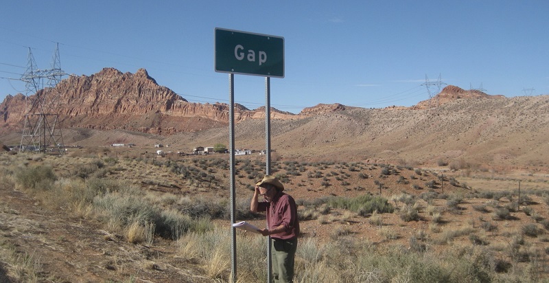
Dr. James W. Sears, University of Montana
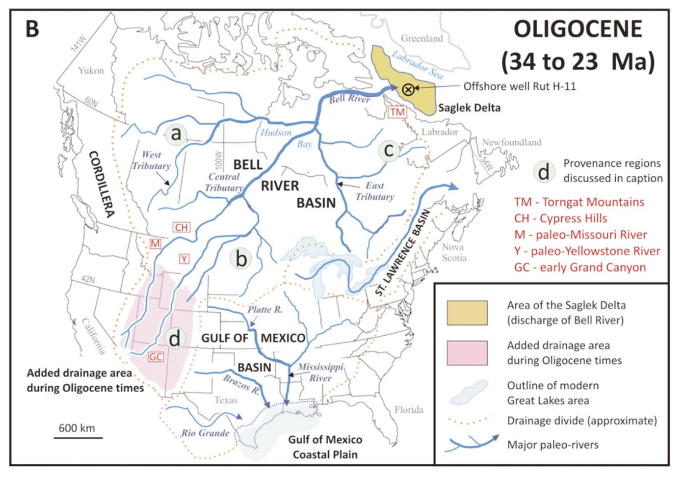
Provenance regions discussed in presentation.
If you cannot access Canadian Geoscience Volume 49, No. 1, see the articles linked after Jim Sears’ biography.
Abstract: The origin of Grand Canyon is still debated. Where did the Colorado flow to the sea when it first started cutting the canyon? Where was its delta? New evidence shows erosion was deeply dissecting the canyon and Colorado Plateau for 20 million years before the first grain of sand reached its modern delta in the Gulf of California. The Gulf didn’t even exist before the canyon’s Inner Gorge was incised.
I propose that the missing delta is way up north in Canada’s Labrador Sea. Luke Beranek of Memorial University and I sampled sand cuttings from a deep exploration well in a giant delta in the Labrador Sea. The sand was deposited when early Grand Canyon was eroding. We extracted zircon sand grains from the cuttings and U-Pb dated them at the University of Arizona Laserchron Lab. We found that, indeed, groups of the grains matched potential sources in the southern Colorado Plateau.
The river was the scale of the Amazon, and would have flowed south to north across the Colorado Plateau and through active grabens in Colorado’s Brown’s Park and Wyoming’s Beaver Rim, to the Big Horn and Yellowstone Rivers. The grabens collected tell-tale detrital zircons linking the southern Colorado Plateau to the Labrador Sea delta. The Yellowstone joined the paleo-Bell River of Canada to reach the Labrador Sea. The gigantic river was destroyed by tectonics, volcanism, and continental glaciation. But evidence remains in tiny zircon sand grains.
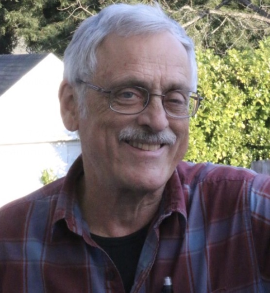
Bio: Jim Sears recently retired from a long career as a Professor of Geology at the University of Montana. He has been intrigued about the origin of Grand Canyon ever since his undergrad days at Northern Arizona University, where, as a devoted member of the Hiking Club, he trekked hundreds of miles in the canyon. At the University of Wyoming he completed a master’s degree on Grand Canyon Precambrian geology, then went on to complete a PhD in geology at Queen’s University in Canada, with a project in the Canadian Cordillera. His geologic experiences in Grand Canyon, Canada, Wyoming, and Montana led him to the idea that the early canyon may have been carved by a large river that flowed from the canyon, north through Wyoming and Montana, to great delta in Canada’s Labrador Sea. Sears recently returned to Canada to sample detrital zircons from the Labrador delta to test his hypothesis. With Luke Beranek of Memorial University, Sears dated the samples at the University of Arizona Laserchron Lab and indeed found direct links to the southern Colorado Plateau.
Link to related article in Earth Magazine (2018) The Paleo-Bell River: North America’s vanished Amazon
Link to article in GSA Today Late Oligocene–early Miocene Grand Canyon: A Canadian connection? by James W. Sears (2013).
View Zoom Recording of “When the Colorado Ran North – Chasing Zircons from Arizona to the Labrador Sea”
Watching this video is best in full screen. (It may sharpen up images.)
No passcode is needed to access this recording. Just click on the video.
Duration: 01:20:09
If you have a lower bandwith internet connection and have problems viewing the above video, here is the video at a lower bitrate: When Colorado Ran North, lower bitrate.
If you use this, please tell coloscisoc.webmaster@gmail.com about your experience.
DISCLAIMER and FAIR-USE STATEMENT: The following Zoom-meeting recording contains content that expresses the opinions, viewpoints, and conclusions of the speakers and does not necessarily reflect the views, policies, or endorsements of the Colorado Scientific Society. This recording is made available to the public for general information and educational purposes only and is not intended to be used for profit. Any use of copyrighted material included therein for other purposes must obtain express written permission from the author.
=
CSS May Meeting
Next-generation stress maps of North America:
Utility for understanding active tectonics and managing induced seismicity
May 11, 2023
Jens-Erick Lundstern (Lund Snee), US Geological Survey
Abstract: The stress field controls active deformation of the Earth’s crust and reflects the processes that drive plate tectonics. Although efforts to map the maximum horizontal stress (SHmax) began in the 1960s, large gaps have persisted in many areas. Here I present a next-generation stress map for North America (figure), which includes several hundred new SHmax orientations as well as the continent’s first quantitative map of relative stress magnitudes (Aφ). In eastern parts of the continent, SHmax is generally oriented northeast–southwest and the style of faulting is compressive (reverse and/or strike-slip faulting). Moving westward into the center of the continent, SHmax rotates clockwise to a nearly east–west direction and the style of faulting becomes less compressive. Western parts of the U.S. are dominantly extensional, with normal and/or strike-slip faulting active. In these areas, SHmax rotates over much shorter distances, but these variations are coherent, especially when viewed at a fine scale. In this presentation, I present the new stress mapping and then discuss its utility for understanding sources of stress and active tectonics. I show how the stress maps contribute to understanding and managing induced seismicity, with particular focus on recent earthquakes in the Permian Basin of western Texas and southeastern New Mexico. By pairing these next-generation stress maps with maps of subsurface faults, it is possible to identify which faults may be the most sensitive to slip due to perturbations such as fluid pressure changes associated with wastewater disposal, hydraulic fracturing, or carbon storage.
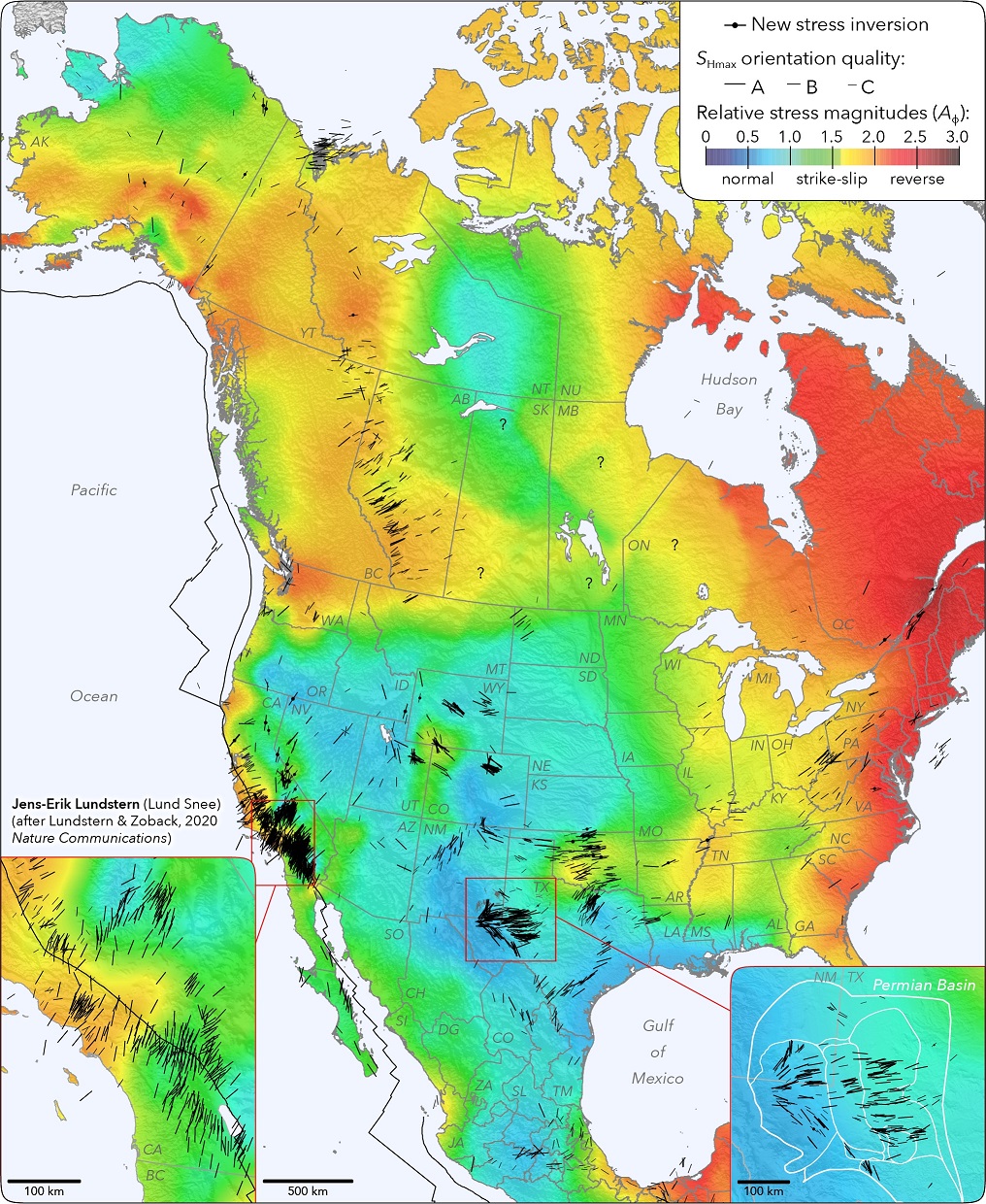
Click here to open a full-size Stress map of North America and enlarge to see details.
Jens Lundstern (Lund Snee) is a research geologist at the U.S. Geological Survey who studies tectonics and geomechanics, focusing on induced seismicity, unconventional energy, and the geologic history of the western USA. He received his Ph.D. in Geophysics from Stanford University, where he developed a new-generation map of the state of stress in North America. Dr. Lundstern received his M.S. in Geological & Environmental Sciences also from Stanford, where he studied the tectonic and paleogeographic history of the Great Basin in the western U.S. He has previously studied the Alpine Fault plate boundary system in New Zealand on a Fulbright Fellowship, and his experience includes work for Statoil (now Equinor) as an exploration geologist in the Gulf of Mexico.
We were not able to record this meeting and do not have a video.
See Jens Lundstern’s PowerPoint Presentation
Download and view Jens Lundstern’s PowerPoint slides from
https://docs.google.com/presentation/d/1Kg-lHM9m_UbETQSEoiWMKFCr7sCtogZv/edit?usp=sharing&ouid=105177457190252268319&rtpof=true&sd=true (266 MB).
You will need to download the PowerPoint presentation from Google Drive.
Then, you can view it via PowerPoint in “Protected View” aka. read-only mode because it has some proprietary fonts.
Double click on the first slide to enlarge it and page through the slides.
=
August
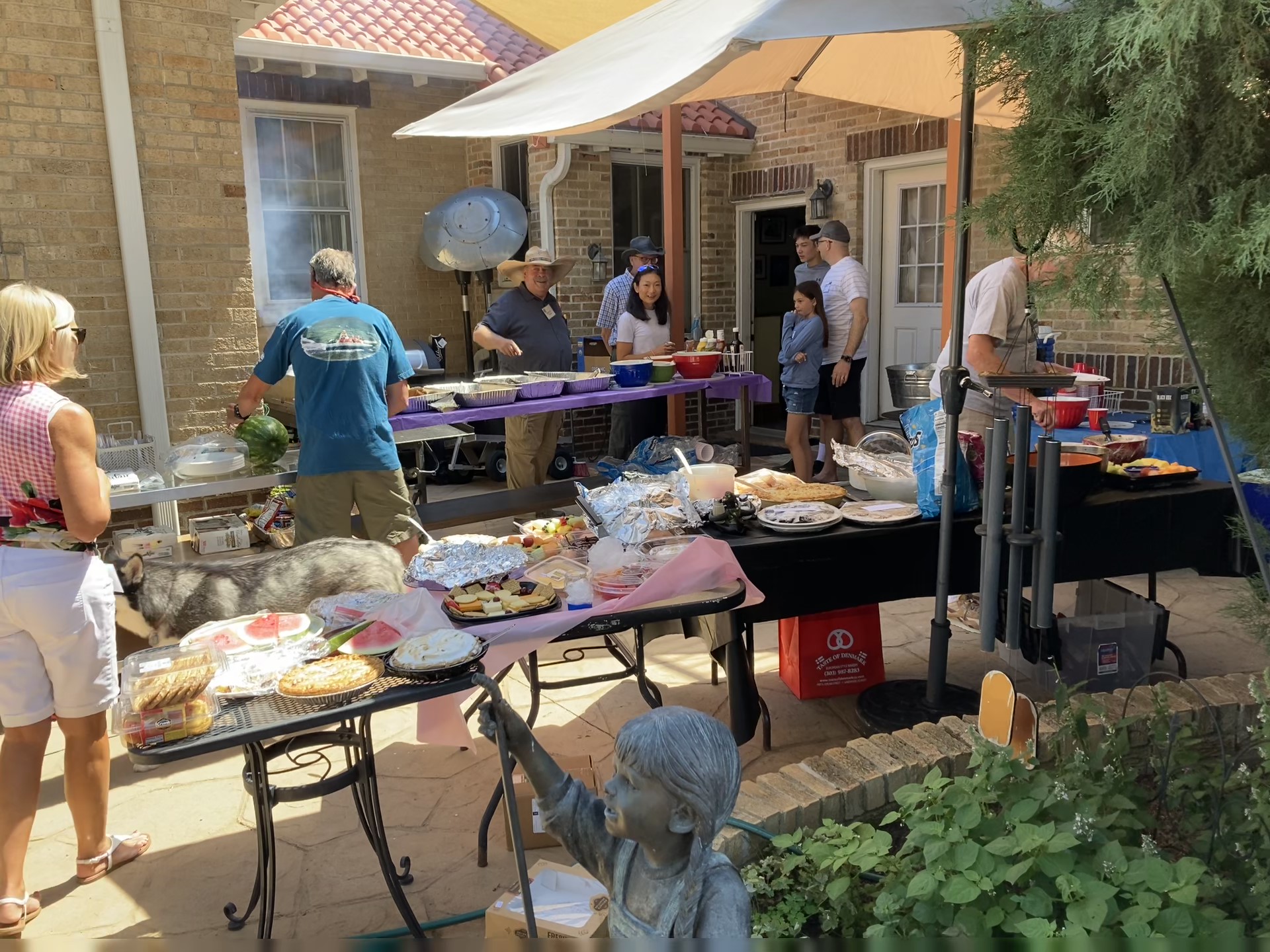
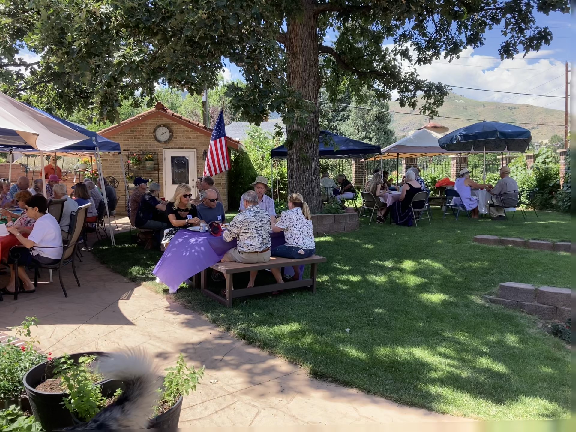
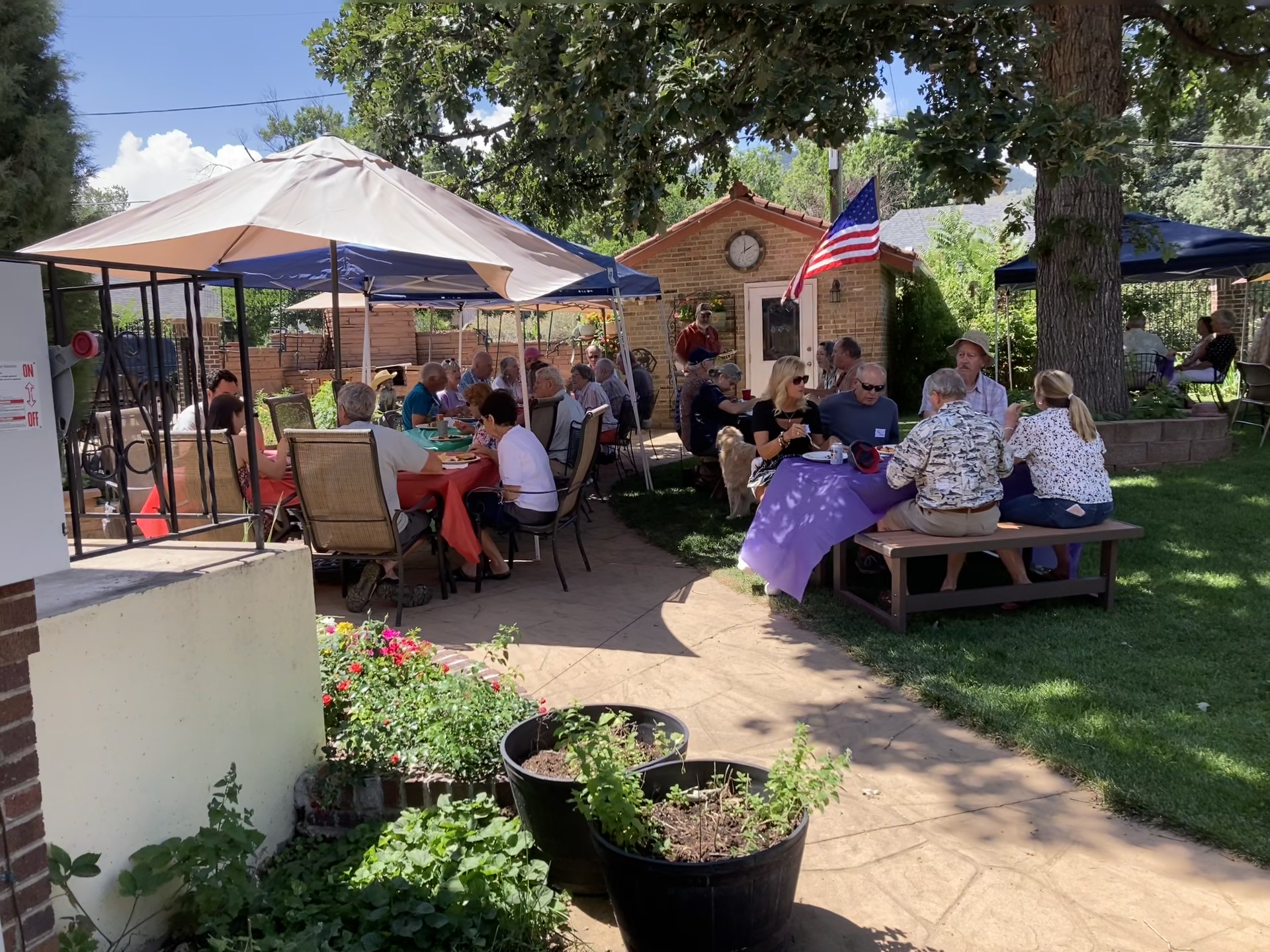
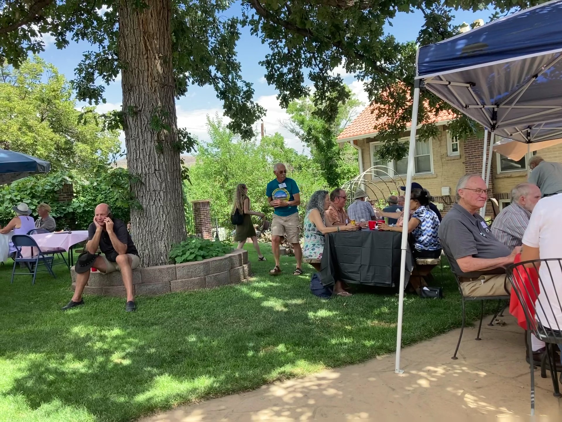
Summer Picnic for Colorado Scientific Society and SIPES
Saturday, August 5, 2023
Hosted by Roger and Connie Knight

=
CSS Past Presidents’ Dinner and September Meeting
‘Golden Age of Geology’,
Plate Tectonics and the Metaluminous-Peraluminous Distinction
September 21, 2023
Monte Swan, MagmaChem Associates, LLC
The Dinner and presentation was at the Mount Vernon Canyon Club
Abstract:
The second half of the twentieth century saw the convergence of the plate tectonic revolution, and multiple new technologies during a fundamental shift from analogue ‘eyes-on-the-rocks’ to digital ‘eyes-on-the-screen’. Strong funding during this shift led to the formation of numerous industry geologic research groups supporting world-wide oil & gas and mineral exploration, the generation of massive amounts of geologic data, many discoveries and a thriving multi-generational geological in-person community. High risk characterized this time, with work in remote deserts, rugged mountains, and deep jungles, while 4-wheeling and camping in virgin wilderness with no phone or radio and paper maps–this describes the life of the geologist back then. It could be considered a ‘Golden Age of Geology’ and it is hard to imagine it ever happening again.
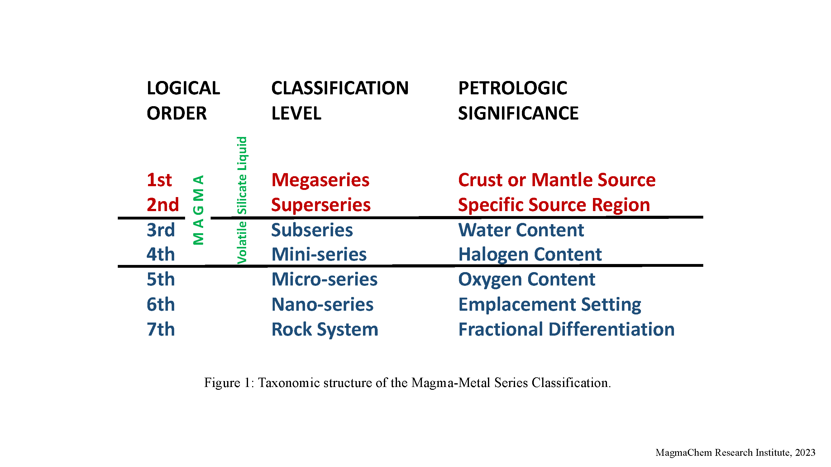
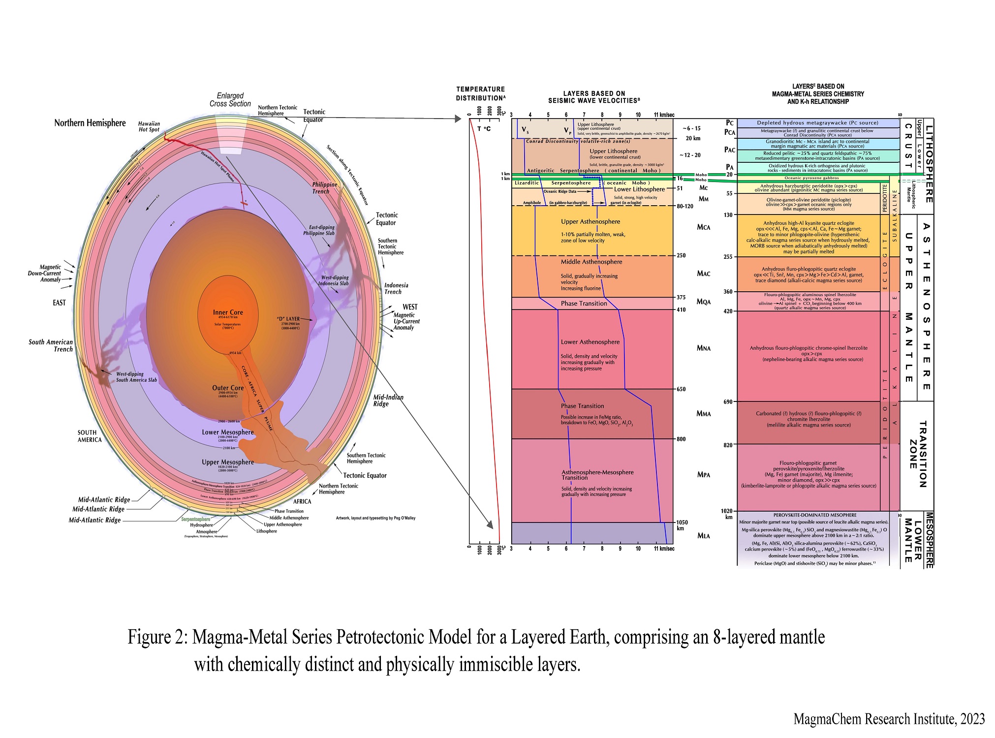
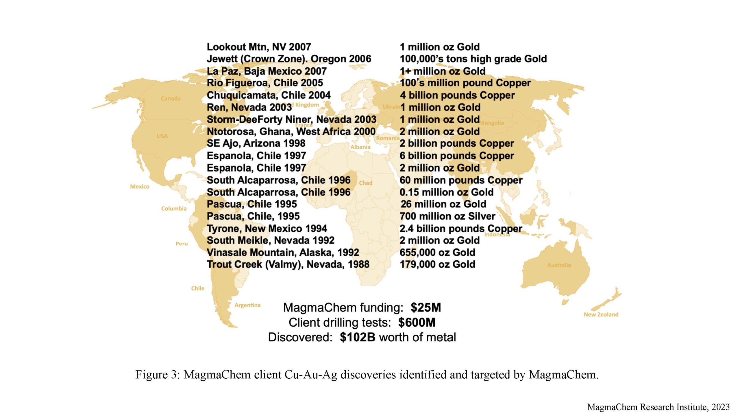
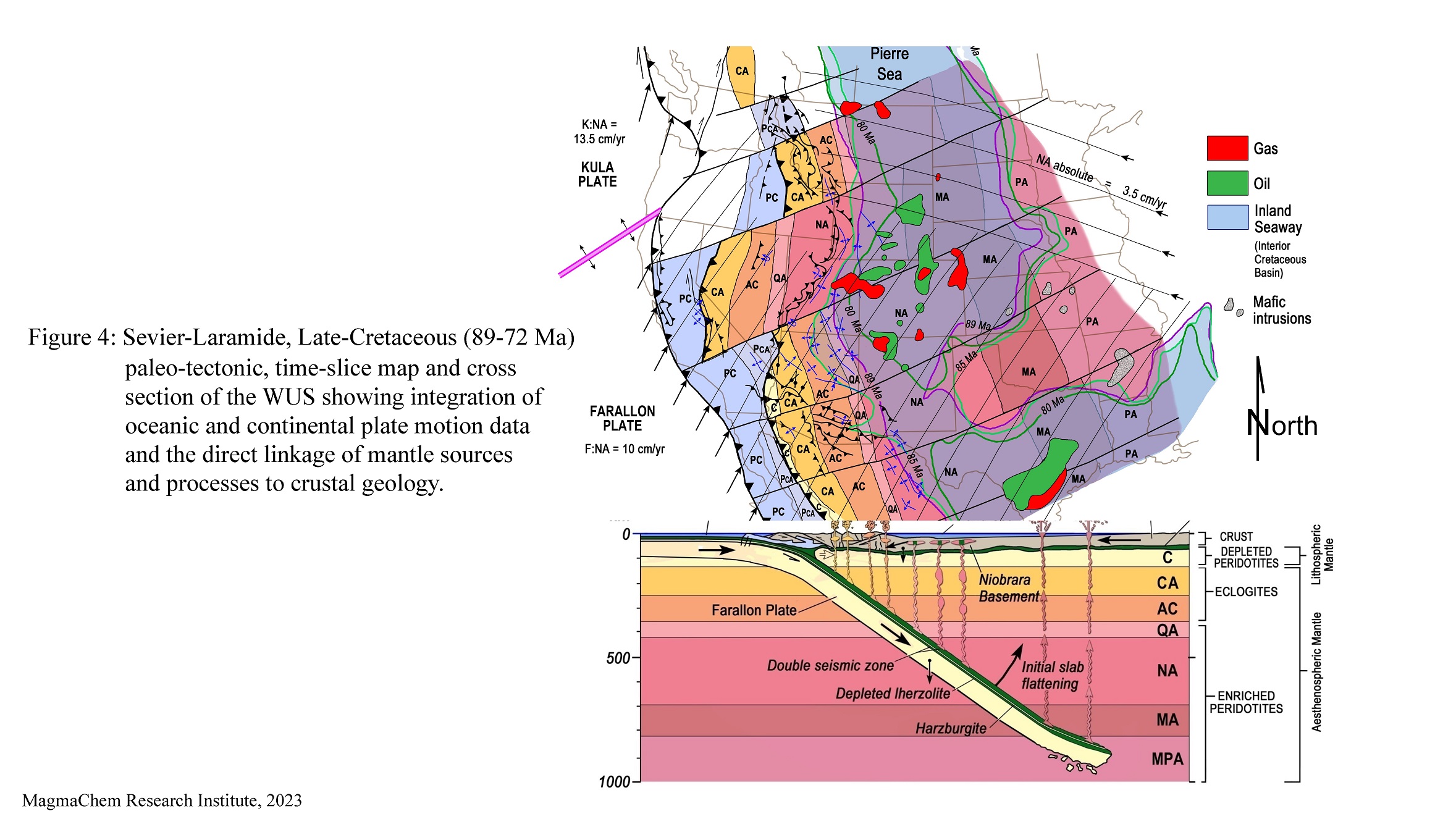
The MagmaChem Exploration Company and Research Institute was founded during this golden age with the mission of integrating the past and future with the new technologies. This was done by focusing on empirical data compilation and the systematic taxonomic organization of specifically magmatism and associated mineral deposit data. The result of this research was a source- and process-based, 7-fold, Linnean type, Magma-Metal Series, chemical classification of igneous rocks and mineral deposits ultimately developing and integrating into an empirically-defined petrotectonic model of a layered earth (Figures 1 and 2). Not only does this give plate tectonics higher resolution, but it increases its predictive power. For example, application to mineral exploration dramatically reduces risk, which led to the discovery of twenty mineral deposits on 3 continents worth one hundred and three billion dollars and could be considered an economic proof of concept (Figure 3). The 89-72 Ma Sevier-Laramide late Cretaceous paleo-tectonic map and cross section of the WUS in Figure 4 is an example of the integration of oceanic and continental plate motion data and the direct linkage of mantle sources and processes to crustal geology.
This presentation will present an overview of the results of MagmaChem’s research and then focus on one of MagmaChem’s most important distinctions–the plate tectonic settings and resource implications of: 1) moderate to steep, subduction-generated, metaluminous igneous rocks, mineral deposits and serpentinization; and 2) flat, subduction-generated, peraluminous, igneous rocks, mineral deposits and serpentinization (Figures 5 and 6).
Notes:
- Figures 2, 4, and 6, below, contain a lot of detail, and they were resized to load in a reasonable time.
To zoom in on these images, click here to download Plate Tectonics and the Metaluminous-Peraluminous Distinction 10.6 MB, a PDF with the images at full resolution. - “Metaluminous rocks are igneous rocks that have a molar proportion of aluminium oxide lower than the combination of calcium oxide, sodium oxide and potassium oxide. …” – Wikipedia
- “Peraluminous rocks are igneous rocks that have a molecular proportion of aluminium oxide higher than the combination of sodium oxide, potassium oxide and calcium oxide. …” – Wikipedia
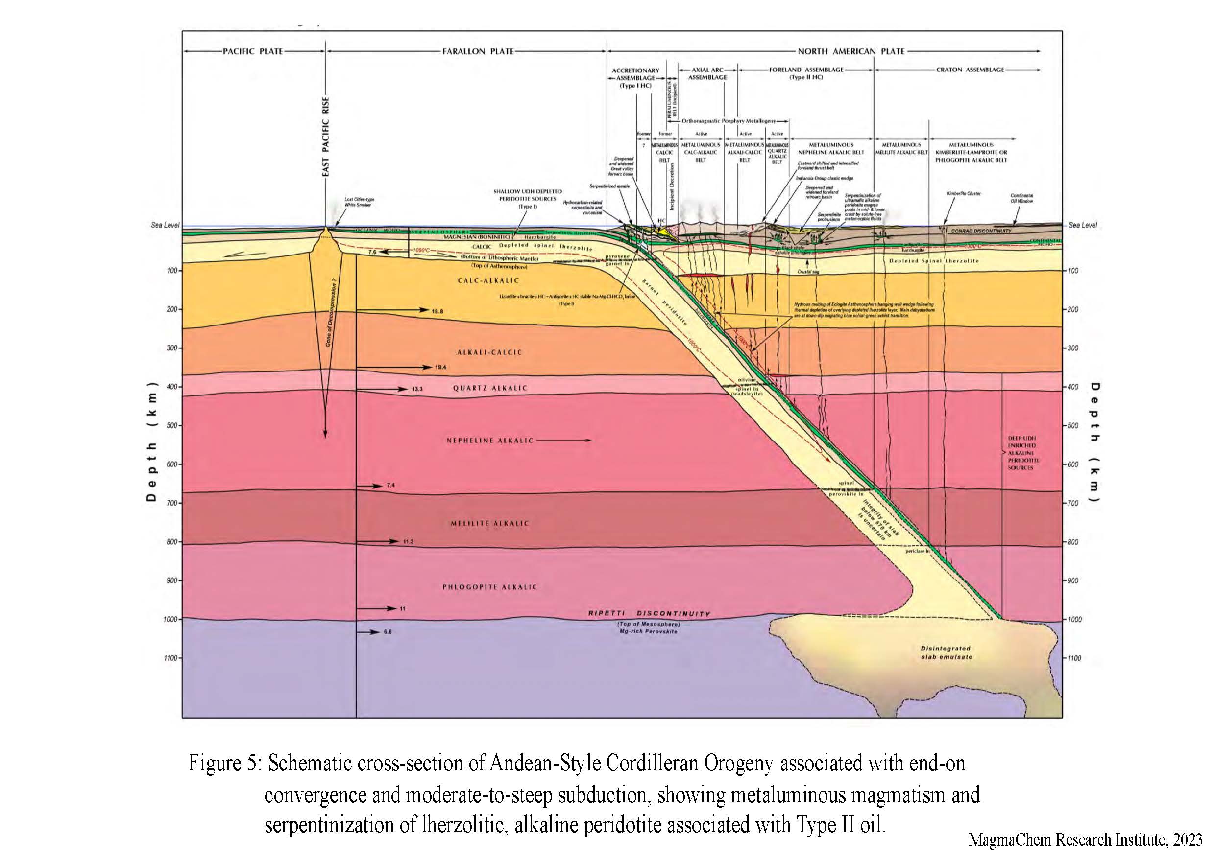
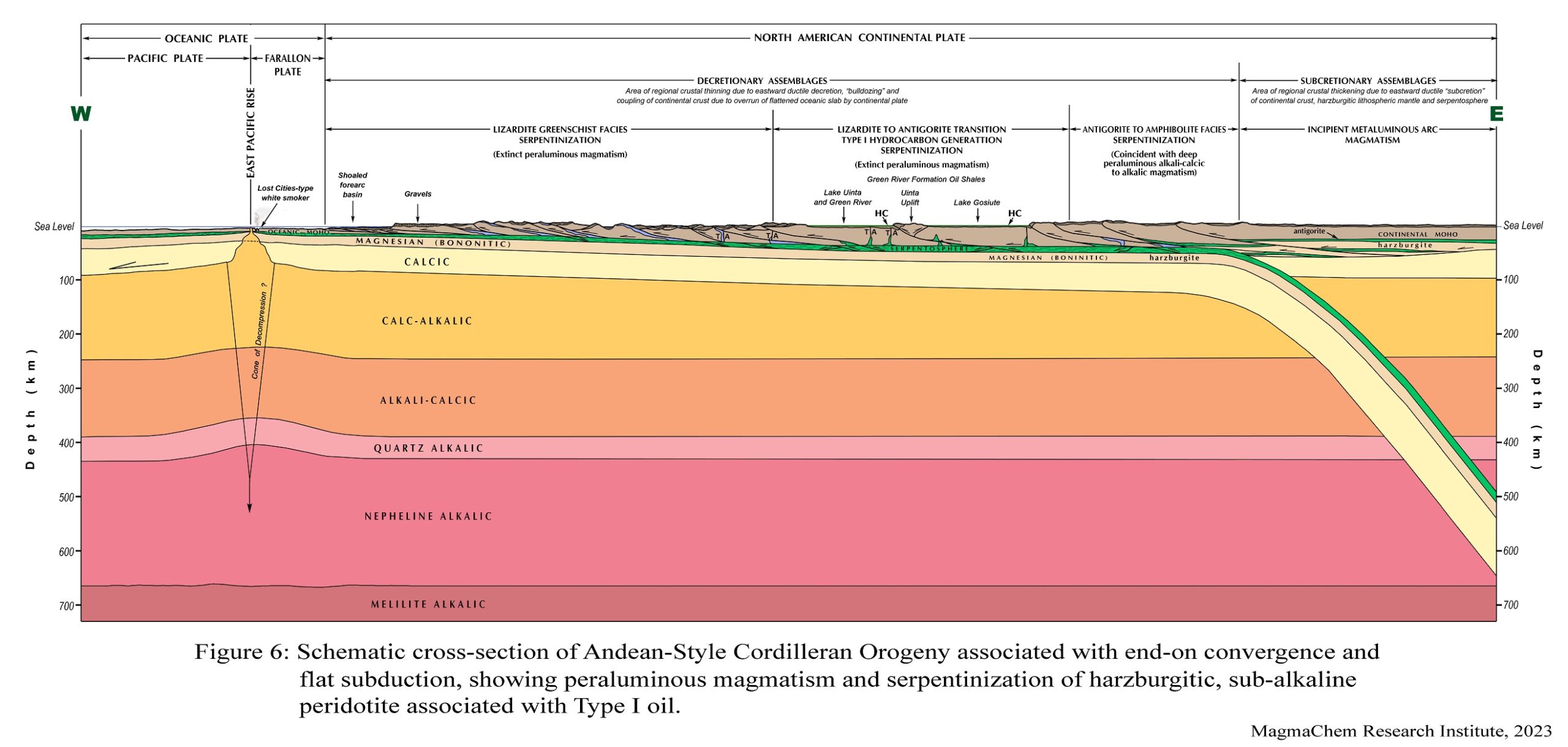
Click here to download Plate Tectonics and the Metaluminous-Peraluminous Distinction 10.6 MB, a PDF with the abstract and all figures in full resolution.
Monte M. Swan
Founder, MagmaChem Research Institute
President, MagmaChem Associates, LLC
Monte is a geologist with international mineral and petroleum exploration experience. He began his career as a research geologist for Kennecott’s Geological Research Group focusing on basement lithology and structure and as an exploration geologist for Newmont Mining Company at the time of their initial major gold discoveries in Nevada. In 1983 he co-founded MagmaChem Exploration, LLC and helped built a client base to fund the MagmaChem concept. He is now president of MagmaChem Associates, LLC and co-founder of the MagmaChem Research Institute. He was instrumental in development of a broad client base to fund MagmaChem. His clients have included virtually all the major mining and oil and gas companies, in addition to groups such as the USGS and DOE. He has special interest in basement geology, kinematic analysis and fluid flow and has compiled large exploration databases for Mexico, British Columbia, the Western US, and Eastern Canada. He has been an adjunct professor, is a published author and has been an author or co-author for many of MagmaChem’s 160 abstracts and papers and involved in many of the 11 theses and dissertations sponsored by MagmaChem. The MagmaChem technology has dramatically reduced risk for clients, directly contributing to the discovery of 20 economic gold-copper-silver deposits on 3 continents worth more than $100 billion.
Monte earned his B.S. degree in Geological Engineering from Michigan Technological University and M.S. degree in Geology from the University of Arizona. He has been a member and presented papers to numerous professional geologic associations such as: Arizona Geological Society (AGS), the Geological Society of Nevada (GSN), the Society of Economic Geologists (SEG), Denver Region Exploration Geologists Society (DREGS), Society for Mining, Metallurgy, and Exploration (SME), the Geological Society of America (GSA), the American Institute of Mining Engineers (AIME), the American Association of Petroleum Geologists (AAPG), and the Rocky Mountain Association of Geologists (RMAG).
View Zoom Recording of ‘Golden Age of Geology’; Plate Tectonics and the Metaluminous-Peraluminous Distinction
Watching this video is best in full screen. (It may sharpen up images.)
No passcode is needed to access this recording. Just click on the video.
Duration: 01:26:03
DISCLAIMER and FAIR-USE STATEMENT: The following Zoom-meeting recording contains content that expresses the opinions, viewpoints, and conclusions of the speakers and does not necessarily reflect the views, policies, or endorsements of the Colorado Scientific Society. This recording is made available to the public for general information and educational purposes only and is not intended to be used for profit. Any use of copyrighted material included therein for other purposes must obtain express written permission from the author.
=
CSS October Meeting
Slip sliding away – Impacts to Denali National Park by climate change, permafrost thaw, and resulting geologic hazards
October 17, 2023
Denny Capps, National Terrestrial Geomorphologist, Geologic Resources Division, National Park Service
Our meeting was at the Calvary Church Golden
Abstract – Climate change is already causing a literal and metaphorical phase change in Denali National Park and Preserve. Permafrost thaw in and around the area is increasing the frequency and severity of geologic hazards and associated impacts to infrastructure. For example, Denali is currently building a $150+-million bridge across a landslide that was likely triggered by ice-rich permafrost thaw. Climate trends and predictions indicate that the thaw is likely to continue and may accelerate, continuing and worsening these impacts. We need updated and improved climate, permafrost, landslide, and infrastructure monitoring and modeling across a range of scales to properly adjust to the ongoing rapid change. We also need to raise awareness of these challenges in our communities and organizations through education and outreach because we have common challenges with permafrost thaw across high-latitude and high-elevation areas. Join us for a presentation and discussion about these challenges and potential solutions.
Denny Capps, National Terrestrial Geomorphologist, Geologic Resources Division, National Park Service
Formerly: Park Geologist, Denali National Park and Preserve
Education:
B.S. – Geology, Louisiana Tech University
M.S – Earth Science, Montana State University
Ph.D. – Earth Science, Simon Fraser University
View Zoom Recording of Slip sliding away – Impacts to Denali National Park by climate change, permafrost thaw, and resulting geologic hazards
Watching this video is best in full screen. (It may sharpen up images.)
No passcode is needed to access this recording. Just click on the video.
Duration: 01:14:36
DISCLAIMER and FAIR-USE STATEMENT: The following Zoom-meeting recording contains content that expresses the opinions, viewpoints, and conclusions of the speakers and does not necessarily reflect the views, policies, or endorsements of the Colorado Scientific Society. This recording is made available to the public for general information and educational purposes only and is not intended to be used for profit. Any use of copyrighted material included therein for other purposes must obtain express written permission from the author.
=
CSS November Meeting
Climate as seen through the lens of Colorado’s Glaciers
Thursday, November 16, 2023
Bob Anderson, University of Colorado, Boulder
The presentation was at the Calvary Church Golden
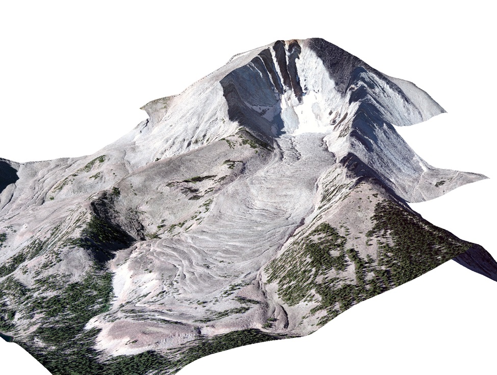
Abstract: Over the last couple million years, Colorado’s glaciers have come and gone to the pace of global climate history. Only 20 thousand years ago we had many glaciers in the state, flowing down the valleys of nearly every mountain range in the state. Yet very few features we would recognize as glaciers now exist in our mountains. I will introduce the history of climate and will discuss what has driven that history over this latest cycle of ice ages. I will then focus on our own glaciers and how we have come to know their more recent history – chiefly their demise since the last glacial maximum 20 thousand years ago. I will then focus on the hundreds of odd glaciers that now dot our mountain valleys. These “rock glaciers” are cloaked with a layer of rocks that serves as something of a parasol to protect them from the heat, and at the same time prevent them from being recognized as glaciers. We are only now coming to understand how these glaciers work.
Bio: Robert S. Anderson
Distinguished Professor • Geomorphology • Hydrologic Sciences Graduate Program, University of Colorado
Research
I am a geomorphologist interested in the evolution of landscapes, with particular emphasis on alpine landscapes.
I focus on processes, including glacial, coastal and fluvial erosion of bedrock. I employ cosmogenic radionuclides to constrain rates and timing in the landscape, field studies to document the specific processes acting, and numerical modeling to knit it all together.
Keywords
glaciers, permafrost, cryosphere, hillslopes, rivers, coastal erosion, weathering, cosmogenic dating, landscape evolution models
Education
- PhD: University of Washington, 1986
- MS: Stanford, 1977
- BS: Williams College, 1974
Awards
- Distinguished Professor, University of Colorado, 2015
- Hazel Barnes Prize, CU-Boulder, 2014
- Fellow, AGU, 2006
- Gladys Cole Award, GSA, 1995
- Presidential Young Investigator Award, NSF, 1991
View Zoom Recording of Climate as seen through the lens of Colorado’s Glaciers
Watching this video is best in full screen. (It may sharpen up images.)
No passcode is needed to access this recording. Just click on the video.
Duration: 01:54:57
DISCLAIMER and FAIR-USE STATEMENT: The following Zoom-meeting recording contains content that expresses the opinions, viewpoints, and conclusions of the speakers and does not necessarily reflect the views, policies, or endorsements of the Colorado Scientific Society. This recording is made available to the public for general information and educational purposes only and is not intended to be used for profit. Any use of copyrighted material included therein for other purposes must obtain express written permission from the author.
=
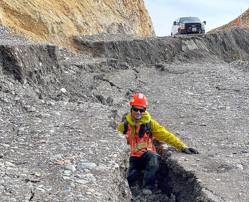
CSS December Annual Business Meeting and Past President’s Address
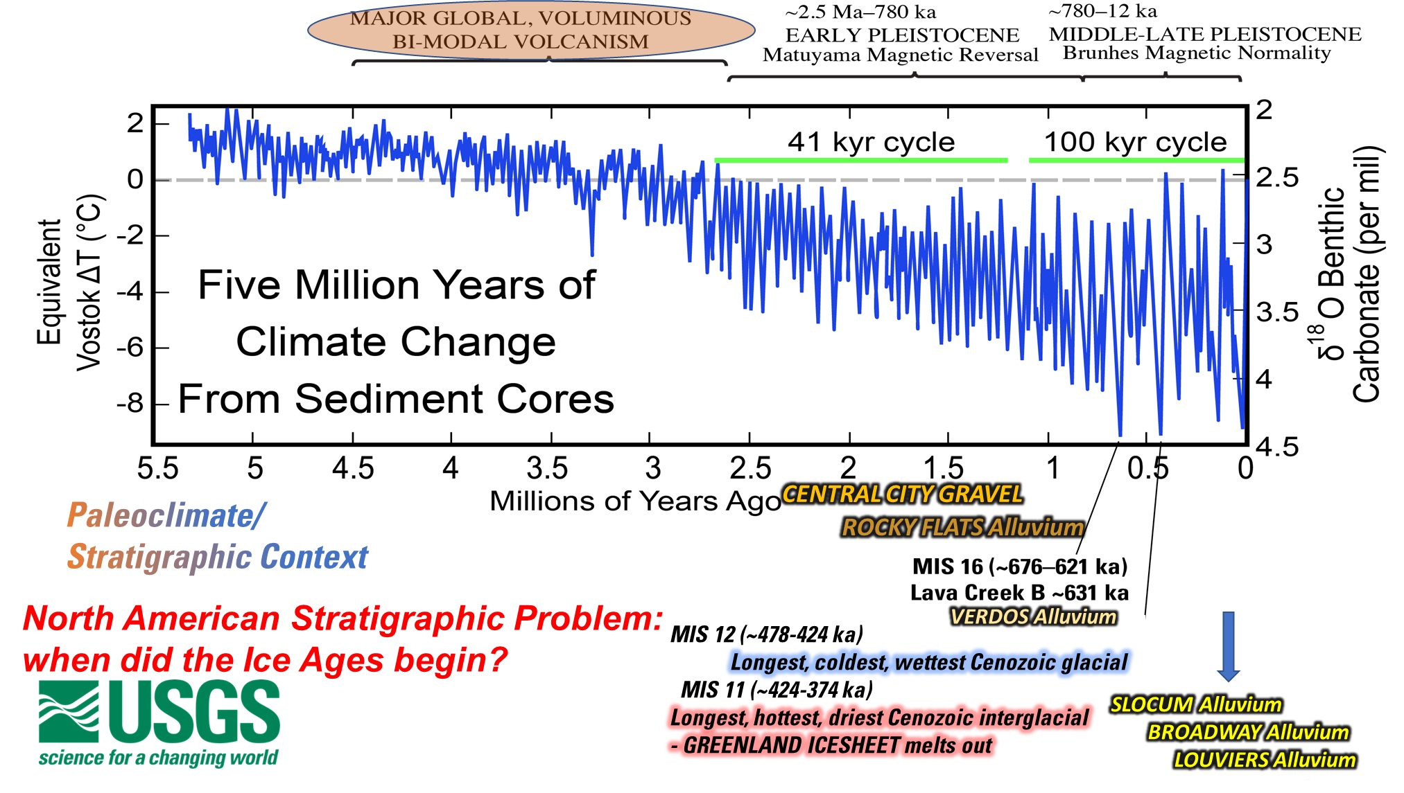
The Central City Gravel and Regional Revelations
Neogene Tectonomagmatic Fragmentation and Middle Pleistocene Glaciofluvial Integration of North American River Systems: New Chronologies Reveal Elusive Neotectonics, Profound Unconformities, and the Reality of Fascinating Landscapes and Amazing Geologic Processes
Tuesday, December 12, 2023
Cal Ruleman, US Geological Survey
We held our dinner at the New Terrain Brewing Company.
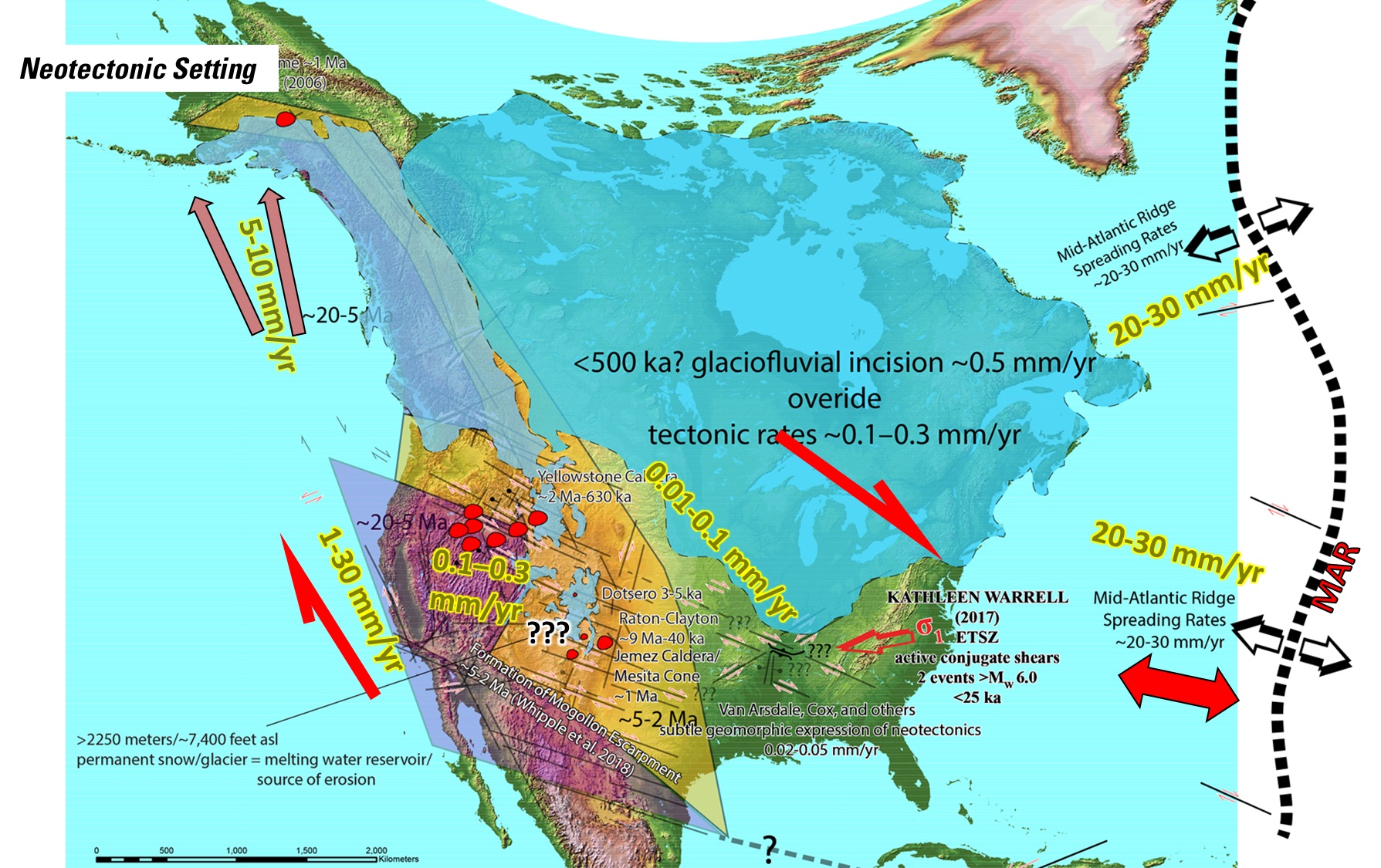
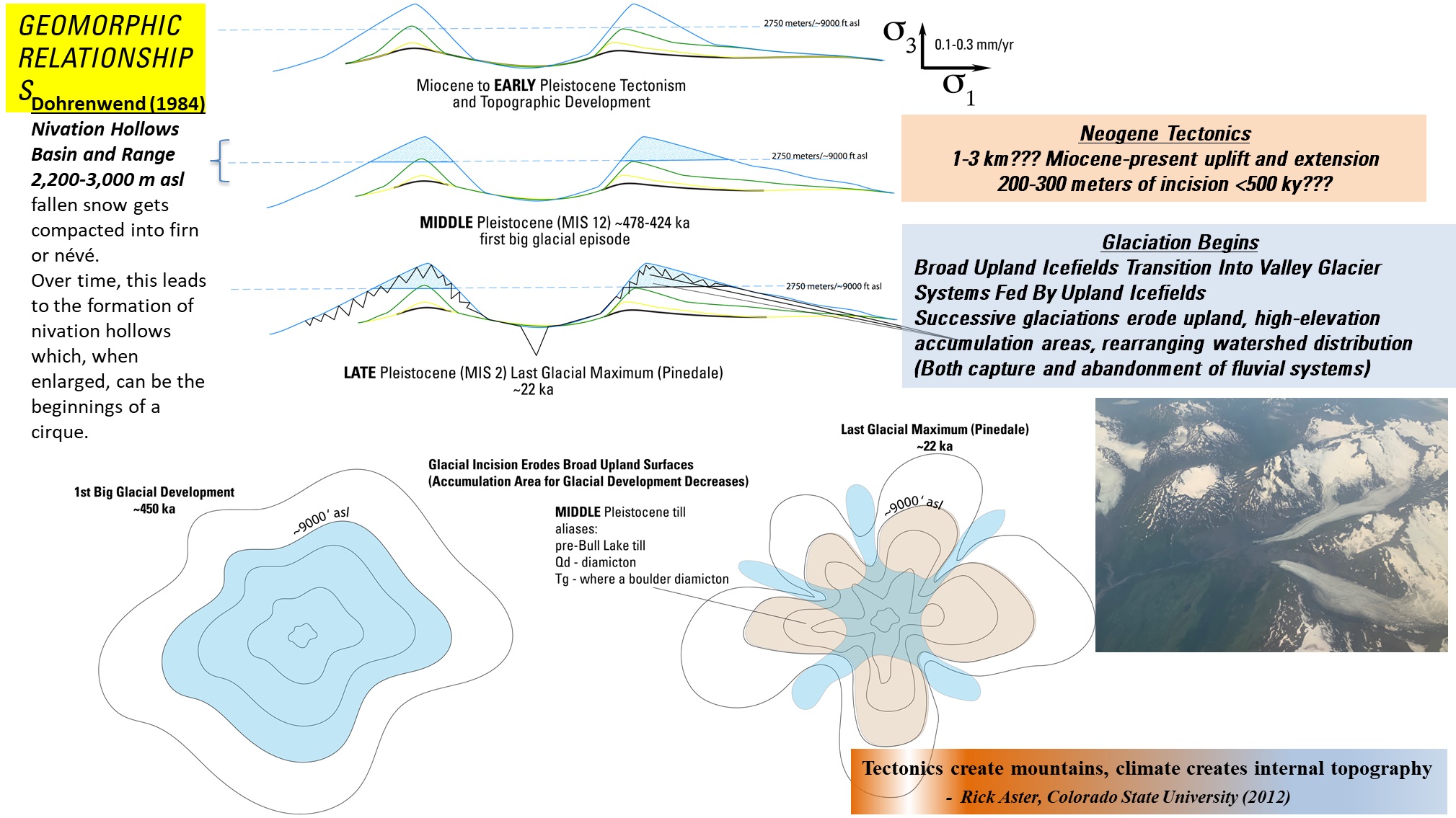
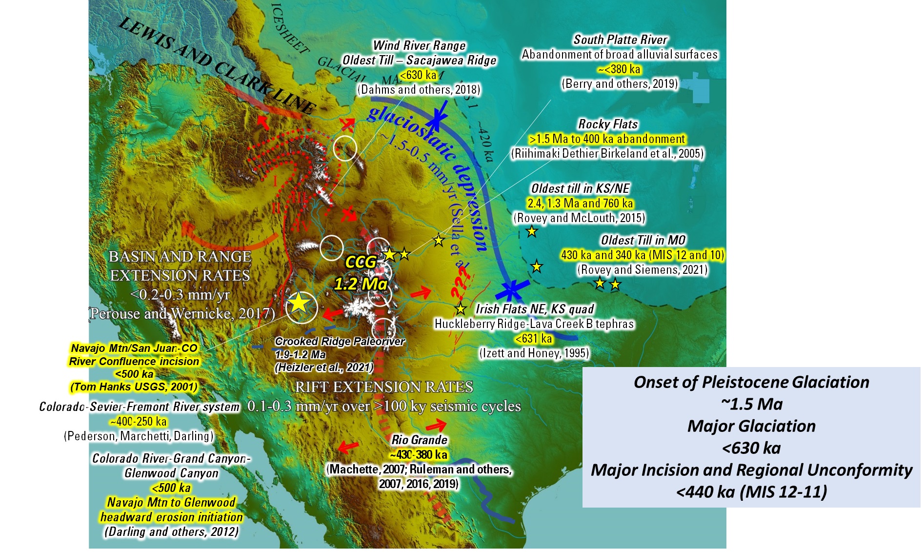
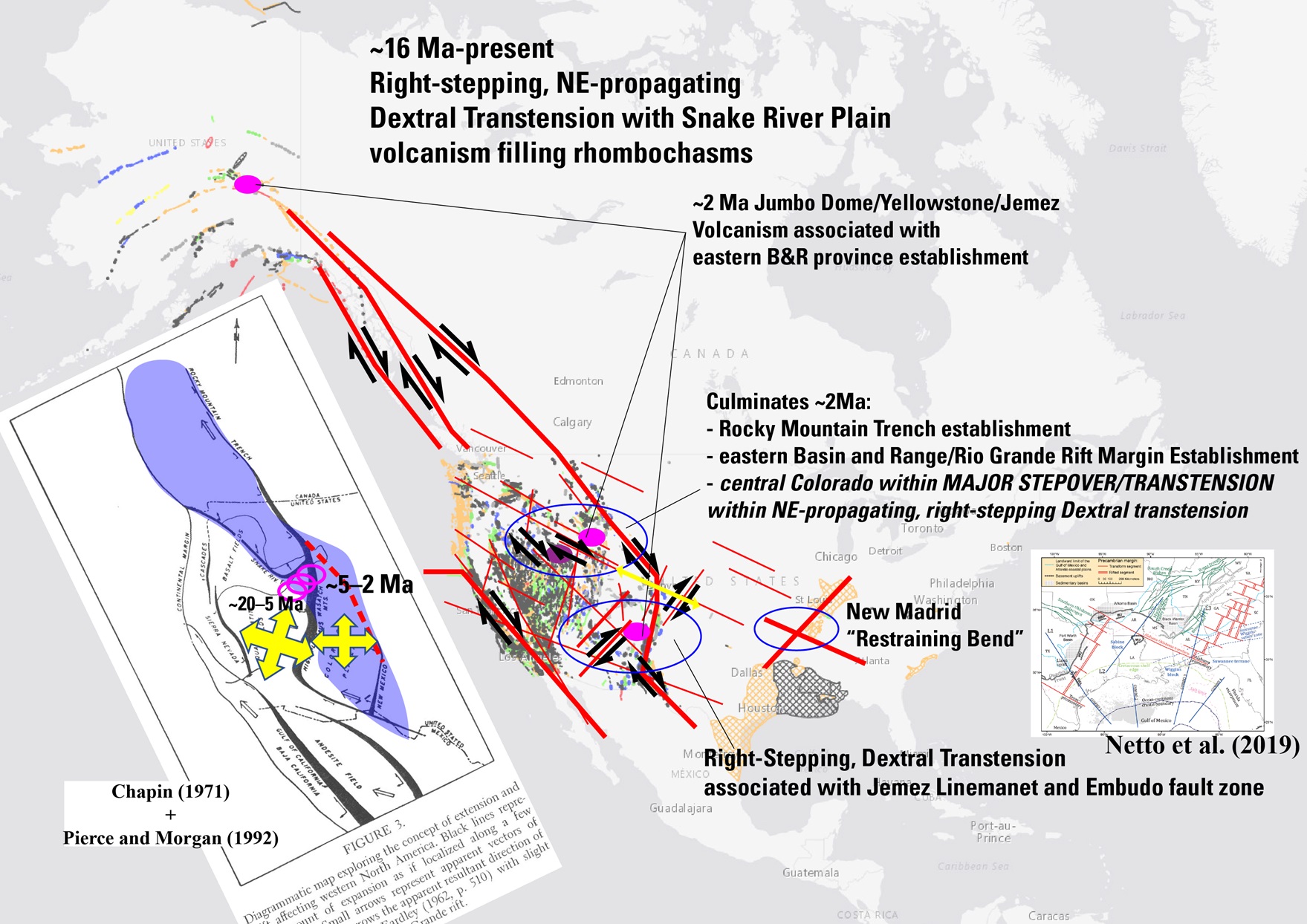
The Central City Gravel and Regional Revelations
Abstract: Within the Front Range, several continued debates and problems occur:
1) Front Range Structure and its Origin, which are directly tied to potential Earthquake Hazards and North American neotectonics; and
2) When did Pleistocene glacial environments begin and what was the extent and geomorphic repercussions, which can be directly applied to Paleoclimate Histories and Cause and Effect of Glacial Episodes and Dramatic Climatic Change in the geologic record.
The Central City Gravel and its regional correlatives provide data to address both debates. Herein, I continue where the working model was presented to CSS in 2017, and couple classic geologic and geomorphic relationships and datasets with contemporary neotectonic, paleoclimatic, and NEW chronologic data to provide a simple solution to both problems. And additionally, provide insight to why possibly the largest gap in the human evolutionary record is between ~400-200 thousand years, coincident with the most extreme global geomorphic interval in the Pleistocene.
Cal Ruleman graduated from University of Montana, Missoula – 1999: B.A. and Montana State University, Bozeman – 2002: M.S.
Cal’s current research includes:
- Neotectonics of the northern Rio Grande rift between Taos, New Mexico and Leadville, Colorado
- Geomorphic evolution and timing of basin integration in the San Luis Valley, Colorado and New Mexico
- Rates of bedrock canyon incision along the Rio Grande, New Mexico
- Timing late Pleistocene glacial maximum and rates of deglaciation, central Colorado
View Presentation Slides of Central City Gravel and Regional Revelations
We were not able to process the recording of the Zoom meeting.
But, we do have the slides that Cal Ruleman presented, which you can download and view:
View Cal’s slides of Central City Gravels and Regional Revelations as a PDF (100 MB)
Download them and view via Adobe Acrobat Reader.
View Cal’s slides of Central City Gravels and Regional Revelations via Microsoft PowerPoint (820 MB)
Download them and view via Microsoft PowerPoint.
Colorado Scientific Society Annual Business Meeting
In addition to electing officers, we approved the first update to the Colorado Scientific Society Constitution and Bylaws since 2001 by a vote of the membership.
For details see: Colorado Scientific Society Constitution and Bylaws